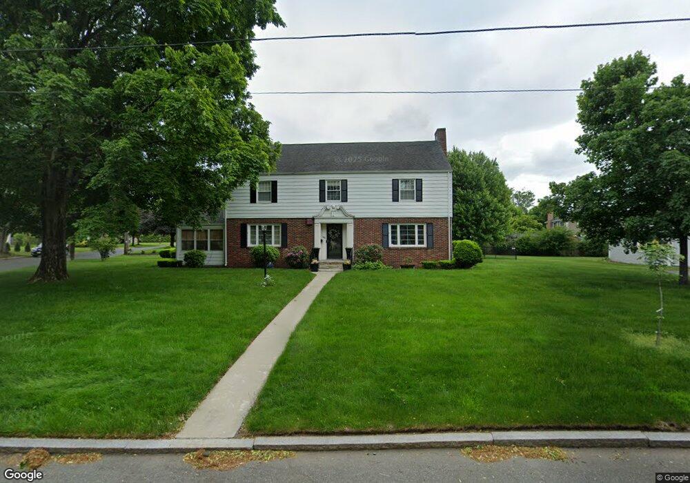
103 S Branch Pkwy Springfield, MA 01118
East Forest Park NeighborhoodEstimated Value: $348,000 - $458,000
4
Beds
4
Baths
2,570
Sq Ft
$159/Sq Ft
Est. Value
About This Home
This home is located at 103 S Branch Pkwy, Springfield, MA 01118 and is currently estimated at $407,924, approximately $158 per square foot. 103 S Branch Pkwy is a home located in Hampden County with nearby schools including Mary A. Dryden Veterans Memorial School, M Marcus Kiley Middle, and Springfield High School of Science and Technology.
Ownership History
Date
Name
Owned For
Owner Type
Purchase Details
Closed on
Jan 16, 2018
Sold by
Keyes Daniel M
Bought by
Keyes Daniel M
Current Estimated Value
Purchase Details
Closed on
Dec 15, 2017
Sold by
Keyes Daniel M
Bought by
Keyes Daniel M
Purchase Details
Closed on
Jan 28, 2013
Sold by
Keyes 3Rd Daniel M and Keyes Janice A
Bought by
Keyes 3Rd Daniel M
Purchase Details
Closed on
Jan 16, 2013
Sold by
Keyes Daniel M Jr Est
Bought by
Keyes 3Rd Daniel M and Keyes Janice A
Create a Home Valuation Report for This Property
The Home Valuation Report is an in-depth analysis detailing your home's value as well as a comparison with similar homes in the area
Home Values in the Area
Average Home Value in this Area
Purchase History
| Date | Buyer | Sale Price | Title Company |
|---|---|---|---|
| Keyes Daniel M | $130,000 | -- | |
| Keyes Daniel M | -- | -- | |
| Keyes 3Rd Daniel M | -- | -- | |
| Keyes 3Rd Daniel M | -- | -- |
Source: Public Records
Tax History Compared to Growth
Tax History
| Year | Tax Paid | Tax Assessment Tax Assessment Total Assessment is a certain percentage of the fair market value that is determined by local assessors to be the total taxable value of land and additions on the property. | Land | Improvement |
|---|---|---|---|---|
| 2025 | $6,052 | $386,000 | $59,100 | $326,900 |
| 2024 | $5,618 | $349,800 | $59,100 | $290,700 |
| 2023 | $5,696 | $334,100 | $56,200 | $277,900 |
| 2022 | $5,554 | $295,100 | $56,200 | $238,900 |
| 2021 | $4,916 | $260,100 | $51,100 | $209,000 |
| 2020 | $4,810 | $246,300 | $51,100 | $195,200 |
| 2019 | $4,906 | $249,300 | $51,100 | $198,200 |
| 2018 | $5,386 | $273,700 | $51,100 | $222,600 |
| 2017 | $5,114 | $260,100 | $56,100 | $204,000 |
| 2016 | $5,220 | $265,500 | $56,100 | $209,400 |
| 2015 | $5,136 | $261,100 | $56,100 | $205,000 |
Source: Public Records
Map
Nearby Homes
- 54 S Shore Dr
- 384 Abbott St
- 100 Derryfield Ave
- 74 Oregon St
- 236 Pondview Dr
- 97 Lancaster St
- 91 Lancaster St
- 7 Ashbrook St
- 283 Plumtree Rd
- 190 Whittum Ave
- 141 Hartford Terrace
- 138 Abbott St
- 75 Carnavon Cir
- 74 Leatherleaf Dr
- 27 Regal St
- 100 Abbott St
- 89 Cherokee Dr
- 95 Benz St
- 20 Lively Ln
- 290 Newton Rd
- 95 S Branch Pkwy
- 412 Gillette Ave
- 50 Arvesta St
- 119 S Branch Pkwy
- 40 Arvesta St
- 87 S Branch Pkwy
- 100 S Branch Pkwy
- 409 Gillette Ave
- 32 Arvesta St
- 120 S Branch Pkwy
- 400 Gillette Ave
- 81 S Branch Pkwy
- 127 S Branch Pkwy
- 401 Gillette Ave
- 51 Arvesta St
- 270 Winton St
- 41 Arvesta St
- 24 Arvesta St
- 80 S Branch Pkwy
- 18 S Shore Dr