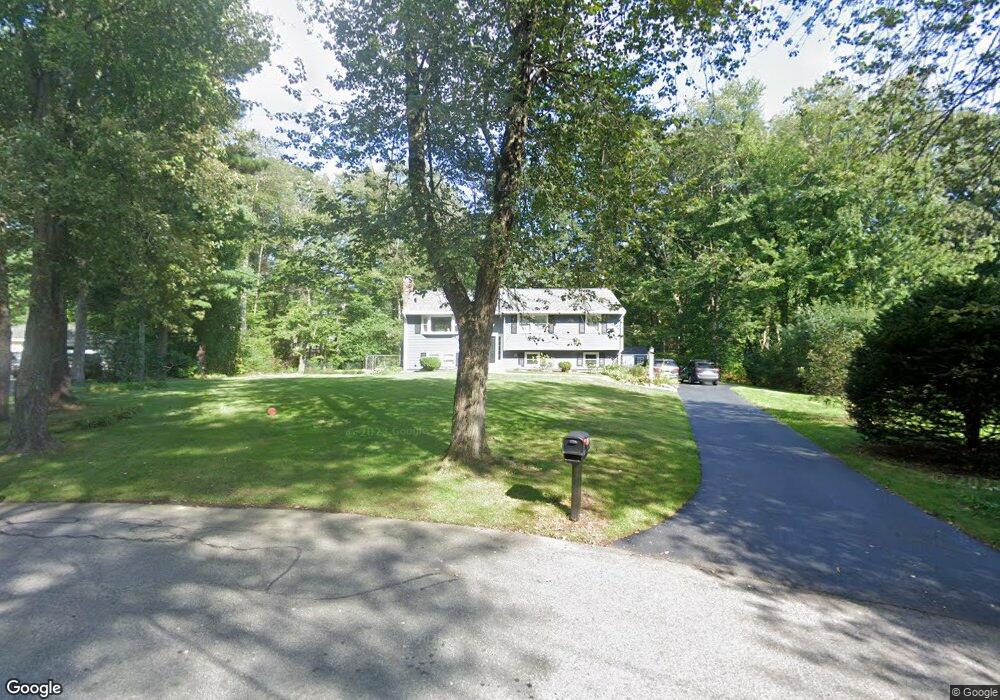
12 Dean Cir Andover, MA 01810
West Andover NeighborhoodEstimated Value: $826,000 - $855,000
4
Beds
2
Baths
1,924
Sq Ft
$439/Sq Ft
Est. Value
About This Home
This home is located at 12 Dean Cir, Andover, MA 01810 and is currently estimated at $843,722, approximately $438 per square foot. 12 Dean Cir is a home located in Essex County with nearby schools including Henry C. Sanborn Elementary School, Andover West Middle School, and Andover High School.
Ownership History
Date
Name
Owned For
Owner Type
Purchase Details
Closed on
Apr 8, 2021
Sold by
Martin Jennifer M
Bought by
Jennifer M Martin Ret and Martin
Current Estimated Value
Purchase Details
Closed on
Feb 13, 2018
Sold by
Hartwell 2015 Ft and Hartwell
Bought by
Martin Jennifer M
Home Financials for this Owner
Home Financials are based on the most recent Mortgage that was taken out on this home.
Original Mortgage
$400,000
Interest Rate
3.99%
Mortgage Type
New Conventional
Purchase Details
Closed on
Jul 8, 2013
Sold by
Zhao Shiyan and Li Yunchu
Bought by
Hartwell Thomas P and Hartwell Mary A
Home Financials for this Owner
Home Financials are based on the most recent Mortgage that was taken out on this home.
Original Mortgage
$285,000
Interest Rate
3%
Mortgage Type
New Conventional
Purchase Details
Closed on
May 21, 2004
Sold by
Brosnan Kevin F and Brosnan Laurie M
Bought by
Zhao Shiyan and Li Yunchu
Purchase Details
Closed on
Oct 27, 1995
Sold by
Kang Shin Gyoo
Bought by
Brosnan Kevin F
Purchase Details
Closed on
Aug 31, 1993
Sold by
Nagin Ruth P
Bought by
Kang Shin-Gyoo
Create a Home Valuation Report for This Property
The Home Valuation Report is an in-depth analysis detailing your home's value as well as a comparison with similar homes in the area
Home Values in the Area
Average Home Value in this Area
Purchase History
| Date | Buyer | Sale Price | Title Company |
|---|---|---|---|
| Jennifer M Martin Ret | -- | None Available | |
| Jennifer M Martin Ret | -- | None Available | |
| Martin Jennifer M | $450,000 | -- | |
| Hartwell Thomas P | $380,000 | -- | |
| Zhao Shiyan | $455,000 | -- | |
| Zhao Shiyan | $455,000 | -- | |
| Brosnan Kevin F | $211,500 | -- | |
| Brosnan Kevin F | $211,500 | -- | |
| Kang Shin-Gyoo | $183,700 | -- | |
| Kang Shin-Gyoo | $183,700 | -- |
Source: Public Records
Mortgage History
| Date | Status | Borrower | Loan Amount |
|---|---|---|---|
| Previous Owner | Martin Jennifer M | $400,000 | |
| Previous Owner | Hartwell Thomas P | $285,000 |
Source: Public Records
Tax History Compared to Growth
Tax History
| Year | Tax Paid | Tax Assessment Tax Assessment Total Assessment is a certain percentage of the fair market value that is determined by local assessors to be the total taxable value of land and additions on the property. | Land | Improvement |
|---|---|---|---|---|
| 2024 | $9,087 | $705,500 | $461,800 | $243,700 |
| 2023 | $8,762 | $641,400 | $415,900 | $225,500 |
| 2022 | $8,050 | $551,400 | $361,700 | $189,700 |
| 2021 | $7,657 | $500,800 | $328,800 | $172,000 |
| 2020 | $7,343 | $489,200 | $320,900 | $168,300 |
| 2019 | $7,258 | $475,300 | $311,400 | $163,900 |
| 2018 | $7,061 | $451,500 | $299,500 | $152,000 |
| 2017 | $6,764 | $445,600 | $293,600 | $152,000 |
| 2016 | $6,626 | $447,100 | $293,600 | $153,500 |
| 2015 | $6,409 | $428,100 | $282,100 | $146,000 |
Source: Public Records
Map
Nearby Homes
- 15 Geneva Rd
- 14 Geneva Rd
- 37 Crenshaw Ln Unit 37
- 25 Clubview Dr Unit 25
- 13 Clubview Dr Unit 13
- 22 Haggetts Pond Rd
- 29 Glenwood Dr
- 21 Clubview Dr Unit 21
- 0
- 96 Beacon St
- 38 Lincoln Cir E
- 101 Bellevue Rd
- 11 Devonshire St
- 5 Marc Ln
- 18 Bryan Ln Unit 18
- 10 Martingale Ln Unit 10
- 58 Blanchard St
- 42 Stevens St
- 750 Brookside Dr Unit G
- 105 Central St