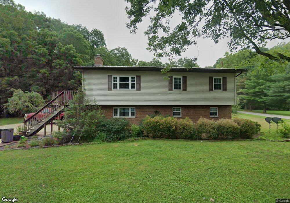
1226 Mill Branch Rd Belpre, OH 45714
Estimated Value: $229,112 - $288,000
3
Beds
2
Baths
1,860
Sq Ft
$136/Sq Ft
Est. Value
About This Home
This home is located at 1226 Mill Branch Rd, Belpre, OH 45714 and is currently estimated at $252,278, approximately $135 per square foot. 1226 Mill Branch Rd is a home located in Washington County with nearby schools including Belpre Elementary School and Belpre High School.
Ownership History
Date
Name
Owned For
Owner Type
Purchase Details
Closed on
Jun 29, 2009
Sold by
Windland Mary Ann and Windland William Joseph
Bought by
Yoak Jeffrey T and Yoak Leslie J
Current Estimated Value
Home Financials for this Owner
Home Financials are based on the most recent Mortgage that was taken out on this home.
Original Mortgage
$127,645
Interest Rate
5.21%
Mortgage Type
FHA
Purchase Details
Closed on
Dec 12, 1994
Bought by
Windland Mary Ann
Create a Home Valuation Report for This Property
The Home Valuation Report is an in-depth analysis detailing your home's value as well as a comparison with similar homes in the area
Home Values in the Area
Average Home Value in this Area
Purchase History
| Date | Buyer | Sale Price | Title Company |
|---|---|---|---|
| Yoak Jeffrey T | $130,000 | Century Title & Escrow Srvcs | |
| Windland Mary Ann | $49,500 | -- |
Source: Public Records
Mortgage History
| Date | Status | Borrower | Loan Amount |
|---|---|---|---|
| Previous Owner | Yoak Jeffrey T | $127,645 |
Source: Public Records
Tax History Compared to Growth
Tax History
| Year | Tax Paid | Tax Assessment Tax Assessment Total Assessment is a certain percentage of the fair market value that is determined by local assessors to be the total taxable value of land and additions on the property. | Land | Improvement |
|---|---|---|---|---|
| 2024 | $2,364 | $59,510 | $9,890 | $49,620 |
| 2023 | $2,364 | $59,510 | $9,890 | $49,620 |
| 2022 | $2,351 | $59,510 | $9,890 | $49,620 |
| 2021 | $1,959 | $46,490 | $7,560 | $38,930 |
| 2020 | $1,845 | $46,490 | $7,560 | $38,930 |
| 2019 | $1,837 | $46,490 | $7,560 | $38,930 |
| 2018 | $1,779 | $43,510 | $6,300 | $37,210 |
| 2017 | $1,430 | $43,510 | $6,300 | $37,210 |
| 2016 | $2,182 | $43,510 | $6,300 | $37,210 |
| 2015 | $1,243 | $37,600 | $6,050 | $31,550 |
| 2014 | $1,889 | $37,600 | $6,050 | $31,550 |
| 2013 | $1,224 | $37,600 | $6,050 | $31,550 |
Source: Public Records
Map
Nearby Homes
- 155 Ridgewood Blvd
- 105 Darbywood Ln
- 655 Ridgewood Blvd
- 905 Ridgewood Blvd
- 1462 State Route 339
- 1396 State Route 339
- 1948 State Route 339
- 15 Oakmont Dr
- 1310 Oxbow Rd
- 21 Cherry Hills Dr
- 1103 Farson St
- 2811 Washington Blvd
- 190 Maze Rd
- 130 Maze Rd
- 492 Beach Dr
- 631 Short Brook Rd
- 2313 Washington Blvd
- 135 Dupont Cir
- 2110 Rockland Ave
- 8045 Veto Rd
- 1271 Mill Branch Rd
- 1195 Mill Branch Rd
- 1171 Mill Branch Rd
- 1149 Mill Branch Rd
- 1160 Mill Branch Rd
- 1142 Mill Branch Rd
- 1131 Mill Branch Rd
- 1710 Drag Strip Rd
- 1710 Drag Strip Rd
- 1311 Mill Branch Rd
- 1645 Drag Strip Rd
- 1107 Mill Branch Rd
- 1644 Drag Strip Rd
- 1103 Mill Branch Rd
- 533 Emmaus Rd
- 1072 Mill Branch Rd Unit T298
- 1395 Mill Branch Rd
- 501 Emmaus Rd
- 1111 Mill Branch Rd
- 550 Emmaus Rd