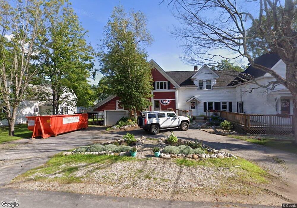
14 Osgood Rd Campton, NH 03223
Estimated Value: $471,000 - $703,000
5
Beds
4
Baths
2,874
Sq Ft
$212/Sq Ft
Est. Value
About This Home
This home is located at 14 Osgood Rd, Campton, NH 03223 and is currently estimated at $609,132, approximately $211 per square foot. 14 Osgood Rd is a home located in Grafton County with nearby schools including Campton Elementary School and Plymouth Regional High School.
Ownership History
Date
Name
Owned For
Owner Type
Purchase Details
Closed on
Jun 19, 2015
Sold by
Preston Wesley H
Bought by
Preston Marissa L
Current Estimated Value
Purchase Details
Closed on
Jul 6, 2009
Sold by
Osgood Dexter H and Osgood Patricia R
Bought by
Preston Wesley H and Preston Marissa L
Home Financials for this Owner
Home Financials are based on the most recent Mortgage that was taken out on this home.
Original Mortgage
$191,468
Interest Rate
4.86%
Mortgage Type
Purchase Money Mortgage
Create a Home Valuation Report for This Property
The Home Valuation Report is an in-depth analysis detailing your home's value as well as a comparison with similar homes in the area
Home Values in the Area
Average Home Value in this Area
Purchase History
| Date | Buyer | Sale Price | Title Company |
|---|---|---|---|
| Preston Marissa L | -- | -- | |
| Preston Wesley H | $195,000 | -- |
Source: Public Records
Mortgage History
| Date | Status | Borrower | Loan Amount |
|---|---|---|---|
| Previous Owner | Preston Wesley H | $182,000 | |
| Previous Owner | Preston Wesley H | $191,468 |
Source: Public Records
Tax History Compared to Growth
Tax History
| Year | Tax Paid | Tax Assessment Tax Assessment Total Assessment is a certain percentage of the fair market value that is determined by local assessors to be the total taxable value of land and additions on the property. | Land | Improvement |
|---|---|---|---|---|
| 2024 | $7,532 | $437,400 | $94,000 | $343,400 |
| 2023 | $7,549 | $262,400 | $45,000 | $217,400 |
| 2022 | $6,631 | $262,400 | $45,000 | $217,400 |
| 2021 | $6,552 | $262,400 | $45,000 | $217,400 |
| 2020 | $6,368 | $262,400 | $45,000 | $217,400 |
| 2019 | $6,090 | $262,400 | $45,000 | $217,400 |
| 2018 | $5,726 | $224,300 | $31,500 | $192,800 |
| 2017 | $6,002 | $220,900 | $31,500 | $189,400 |
| 2016 | $5,277 | $220,900 | $31,500 | $189,400 |
| 2015 | $5,061 | $220,900 | $31,500 | $189,400 |
| 2014 | $5,182 | $220,900 | $31,500 | $189,400 |
| 2013 | $4,996 | $249,900 | $32,900 | $217,000 |
Source: Public Records
Map
Nearby Homes
- 35 Mad River Rd
- 383 Owl St
- 1354 Nh Route 175
- 13 Overlook Rd
- 101 Mad River Rd
- 399 Nh Route 49
- 10 Benjamin Ln Unit 34
- 184 Mad River Rd
- 17 Rising Ridge Rd Unit 3
- 15 Rising Ridge Rd
- 55 Lafayette Rd Unit 2
- 182 Pinnacle Rd Unit 6
- 147 Pemi River Rd
- Lot 6 Edgewater Ln
- 99 Pinnacle Rd
- 20 Merrill Rd
- 32 Merrill Rd
- 0 Checkerberry Ridge Rd Unit 142
- Lot 1 Pegwood Rd
- 90 Sunset Cir
- 21 Old Waterville Rd Unit 7
- 7 Osgood Rd
- 7 Osgood Rd Unit B
- 0 Mad River Rd Unit 4329883
- 0 Mad River Rd Unit 2800078
- 0 Mad River Rd Unit 2703038
- 1372 Nh Route 175
- 002 Owl St
- 4 Old Waterville Rd
- 21 Mad River Rd
- 1377 Nh Route 175
- 1377 New Hampshire Route 175
- 1367-3 Main Street Rt 175 Route
- 1296 Nh Route 175
- 1373 Nh Route 175
- 1373 New Hampshire 175
- 51 Mad River Rd
- 1371 Nh Route 175
- 1364 Nh Route 175
- 50 Mad River Rd