Estimated Value: $329,000 - $356,000
2
Beds
2
Baths
1,200
Sq Ft
$284/Sq Ft
Est. Value
About This Home
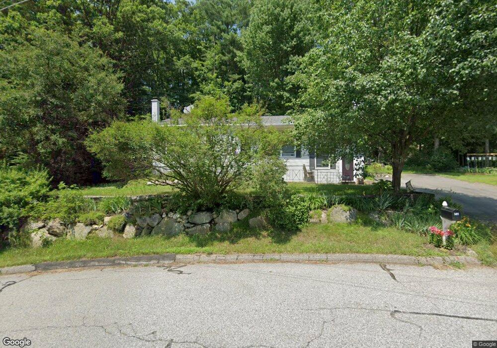
This home is located at 149 Liberty Ln, Keene, NH 03431 and is currently estimated at $341,152, approximately $284 per square foot. 149 Liberty Ln is a home with nearby schools including Greenlee Primary School, Keene Middle School, and Mayland Early College High School.
Ownership History
Date
Name
Owned For
Owner Type
Purchase Details
Closed on
Dec 20, 2021
Sold by
Richard J Berg 2021 Ret and Berg
Bought by
Russo Stephen J and Russo Kathleen M
Current Estimated Value
Home Financials for this Owner
Home Financials are based on the most recent Mortgage that was taken out on this home.
Original Mortgage
$218,250
Outstanding Balance
$199,850
Interest Rate
3.09%
Mortgage Type
Purchase Money Mortgage
Estimated Equity
$141,302
Purchase Details
Closed on
Oct 20, 2021
Sold by
Berg Richard J
Bought by
Richard J Berg 2021 Ret and Berg
Create a Home Valuation Report for This Property
The Home Valuation Report is an in-depth analysis detailing your home's value as well as a comparison with similar homes in the area
Home Values in the Area
Average Home Value in this Area
Purchase History
| Date | Buyer | Sale Price | Title Company |
|---|---|---|---|
| Russo Stephen J | $225,000 | None Available | |
| Russo Stephen J | $225,000 | None Available | |
| Richard J Berg 2021 Ret | -- | None Available | |
| Richard J Berg 2021 Ret | -- | None Available |
Source: Public Records
Mortgage History
| Date | Status | Borrower | Loan Amount |
|---|---|---|---|
| Open | Russo Stephen J | $218,250 | |
| Closed | Russo Stephen J | $218,250 |
Source: Public Records
Tax History Compared to Growth
Tax History
| Year | Tax Paid | Tax Assessment Tax Assessment Total Assessment is a certain percentage of the fair market value that is determined by local assessors to be the total taxable value of land and additions on the property. | Land | Improvement |
|---|---|---|---|---|
| 2024 | $7,265 | $219,700 | $49,000 | $170,700 |
| 2023 | $7,006 | $219,700 | $49,000 | $170,700 |
| 2022 | $6,817 | $219,700 | $49,000 | $170,700 |
| 2021 | $6,872 | $219,700 | $49,000 | $170,700 |
| 2020 | $5,662 | $157,900 | $57,100 | $100,800 |
| 2019 | $5,937 | $157,900 | $57,100 | $100,800 |
| 2018 | $5,861 | $157,900 | $57,100 | $100,800 |
| 2017 | $5,884 | $158,100 | $57,300 | $100,800 |
| 2016 | $5,753 | $158,100 | $57,300 | $100,800 |
| 2015 | $6,674 | $200,500 | $66,700 | $133,800 |
Source: Public Records
Map
Nearby Homes
- 115 Liberty Ln
- 184 Kennedy Dr
- 64 Old Walpole Rd
- 106 Pako Ave
- 224 Darling Rd
- 798 Court St Unit G
- 792 Court St Unit A
- 11 Nut Hatch Ln
- 17 Blue Jay Ct
- 31 Darling Ct
- 39 Windsor Ct Unit B
- 0 Rd Unit 5039440
- 28 Stonehouse Ln
- 38 Stonehouse Ln Unit A
- 220 Hurricane Rd
- 257 Park Ave
- Lot 27-1 Old Walpole Rd
- 0 Stevens St Unit 1
- 18 Stanton Ct
- Rt Highway 12
- 153 Liberty Ln
- 146 Liberty Ln
- 143 Liberty Ln
- 156 Liberty Ln
- 155 Liberty Ln
- 142 Liberty Ln
- 141 Liberty Ln
- 160 Liberty Ln
- 159 Liberty Ln
- 130 Old Walpole Rd
- 7 Autumn Hill Rd
- 124 Old Walpole Rd
- 118 Old Walpole Rd
- 135 Liberty Ln
- 11 Autumn Hill Rd
- 163 Liberty Ln
- 136 Old Walpole Rd
- 164 Liberty Ln
- 134 Liberty Ln
- 10 Autumn Hill Rd