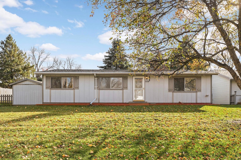
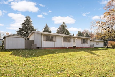
1538 12th Ave W Shakopee, MN 55379
Estimated payment $2,095/month
Highlights
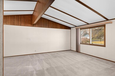
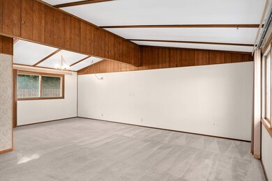
- Vaulted Ceiling
- Corner Lot
- Hobby Room
- Shakopee Senior High School Rated A-
- No HOA
- Living Room
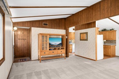
About This Home
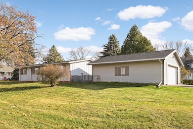
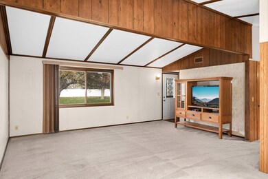
Charming 3-Bedroom Rambler with Finished Basement and Heated Garage! Welcome to this inviting 3-bedroom, 2-bathroom rambler nestled on a spacious 1/3-acre corner lot with a fenced yard and large concrete patio, perfect for outdoor entertaining. The home features soaring vaulted ceilings on the main floor, creating a bright, open, and airy living space. All three bedrooms are conveniently located on the main level, offering comfort and accessibility. The finished basement provides additional living space- ideal for a family room, home office, or recreation area. The oversized two-car detached garage is insulated and ready to be heated, offering plenty of room for vehicles, hobbies, or extra storage. Enjoy peace of mind with a new roof installed just one year ago. The driveway entrance off the cul-de-sac adds privacy and safety, while the location couldn't be better-walking distance to Sweeny Elementary School, SandVenture Community Pool, Lion's Park, Tahpah Park, and Drop Shot Pickleball. This home is fantastic starter home in a great neighborhood. Quick occupancy is preferred, so don't wait-schedule your showing today!
Home Details
Home Type
- Single Family
Est. Annual Taxes
- $3,030
Year Built
- Built in 1979
Lot Details
- 0.35 Acre Lot
- Wood Fence
- Corner Lot
Parking
- 2 Car Garage
- Heated Garage
- Insulated Garage
Home Design
- Flex
- Wood Siding
Interior Spaces
- 1-Story Property
- Vaulted Ceiling
- Living Room
- Combination Kitchen and Dining Room
- Hobby Room
Kitchen
- Range
- Microwave
- Dishwasher
Bedrooms and Bathrooms
- 3 Bedrooms
- 2 Full Bathrooms
Laundry
- Dryer
- Washer
Finished Basement
- Basement Fills Entire Space Under The House
- Drain
- Block Basement Construction
Utilities
- Forced Air Heating and Cooling System
- Gas Water Heater
- Cable TV Available
Community Details
- No Home Owners Association
Listing and Financial Details
- Assessor Parcel Number 270630250
Map
Home Values in the Area
Average Home Value in this Area
Tax History
| Year | Tax Paid | Tax Assessment Tax Assessment Total Assessment is a certain percentage of the fair market value that is determined by local assessors to be the total taxable value of land and additions on the property. | Land | Improvement |
|---|---|---|---|---|
| 2025 | $3,030 | $320,900 | $183,500 | $137,400 |
| 2024 | $3,044 | $303,100 | $178,300 | $124,800 |
| 2023 | $3,170 | $292,900 | $170,100 | $122,800 |
| 2022 | $2,984 | $299,700 | $170,100 | $129,600 |
| 2021 | $2,468 | $246,600 | $136,800 | $109,800 |
| 2020 | $2,578 | $227,100 | $117,100 | $110,000 |
| 2019 | $2,654 | $211,200 | $102,600 | $108,600 |
| 2018 | $2,762 | $0 | $0 | $0 |
| 2016 | $2,598 | $0 | $0 | $0 |
| 2014 | -- | $0 | $0 | $0 |
Property History
| Date | Event | Price | List to Sale | Price per Sq Ft |
|---|---|---|---|---|
| 11/12/2025 11/12/25 | For Sale | $350,000 | -- | $173 / Sq Ft |
Purchase History
| Date | Type | Sale Price | Title Company |
|---|---|---|---|
| Warranty Deed | $190,000 | None Available | |
| Interfamily Deed Transfer | -- | None Available | |
| Deed Of Distribution | -- | None Available |
Mortgage History
| Date | Status | Loan Amount | Loan Type |
|---|---|---|---|
| Open | $125,100 | New Conventional |
Source: NorthstarMLS
MLS Number: 6815987
APN: 27-063-025-0
Disclaimer: Certain information contained herein is derived from information provided by parties other than Homes.com. All information provided is deemed reliable, but is not guaranteed to be accurate and should be independently verified.
![]() Based on information submitted to the MLS GRID. All data is obtained from various sources and may not have been verified by broker or MLS GRID. Supplied Open House Information is subject to change without notice. All information should be independently reviewed and verified for accuracy. Properties may or may not be listed by the office/agent presenting the information. Some IDX listings have been excluded from this website.
Based on information submitted to the MLS GRID. All data is obtained from various sources and may not have been verified by broker or MLS GRID. Supplied Open House Information is subject to change without notice. All information should be independently reviewed and verified for accuracy. Properties may or may not be listed by the office/agent presenting the information. Some IDX listings have been excluded from this website.
The Digital Millennium Copyright Act of 1998, 17 U.S.C. § 512 (the “DMCA”) provides recourse for copyright owners who believe that material appearing on the Internet infringes their rights under U.S. copyright law. If you believe in good faith that any content or material made available in connection with our website or services infringes your copyright, you (or your agent) may send us a notice requesting that the content or material be removed, or access to it blocked.
Notices must be sent in writing by email to DMCAnotice@MLSGrid.com.
The DMCA requires that your notice of alleged copyright infringement include the following information:
(1) description of the copyrighted work that is the subject of claimed infringement;
(2) description of the alleged infringing content and information sufficient to permit us to locate the content;
(3) contact information for you, including your address, telephone number and email address;
(4) a statement by you that you have a good faith belief that the content in the manner complained of is not authorized by the copyright owner, or its agent, or by the operation of any law;
(5) a statement by you, signed under penalty of perjury, that the information in the notification is accurate and that you have the authority to enforce the copyrights that are claimed to be infringed; and
(6) a physical or electronic signature of the copyright owner or a person authorized to act on the copyright owner’s behalf. Failure to include all of the above information may result in the delay of the processing of your complaint.
- 1187 Jackson St S
- 1226 Polk St S
- 1853 Stone Meadow Blvd
- 2075 13th Ave W
- 1259 Taylor St Unit 3
- 1813 6th Ave W
- 2007 10th Ave W Unit 12
- 1279 Taylor St Unit 5
- 2123 Agate Curve
- 2224 Quarry Ln
- 816 Regent Dr
- 1690 Windigo Ln
- 1603 3rd Ave W
- 348 Columbine Ln
- 1121 Scott St S
- 696 Jutland Ave
- 508 Hackney Ave
- 1179 Cubasue Ct
- 1861 Attenborough St
- 1949 Lusitano St
- 1219-1229 Taylor St
- 1220 Taylor St
- 1600 Windermere Way
- 1601 Harvest Ln
- 1619 Windigo Ln
- 730 Pierce St S
- 1620 Lusitano St
- 125 6th Ave E
- 125 Scott St N
- 500 Sommerville St S
- 129 Holmes St S
- 101 Fuller St N
- 931 Market St S
- 205 1st Ave E
- 676 Cobblestone Way
- 609 Market St S
- 118 S Shannon Dr
- 810 3rd Ave E
- 1245 Shakopee Ave E
- 560 Gorman St
