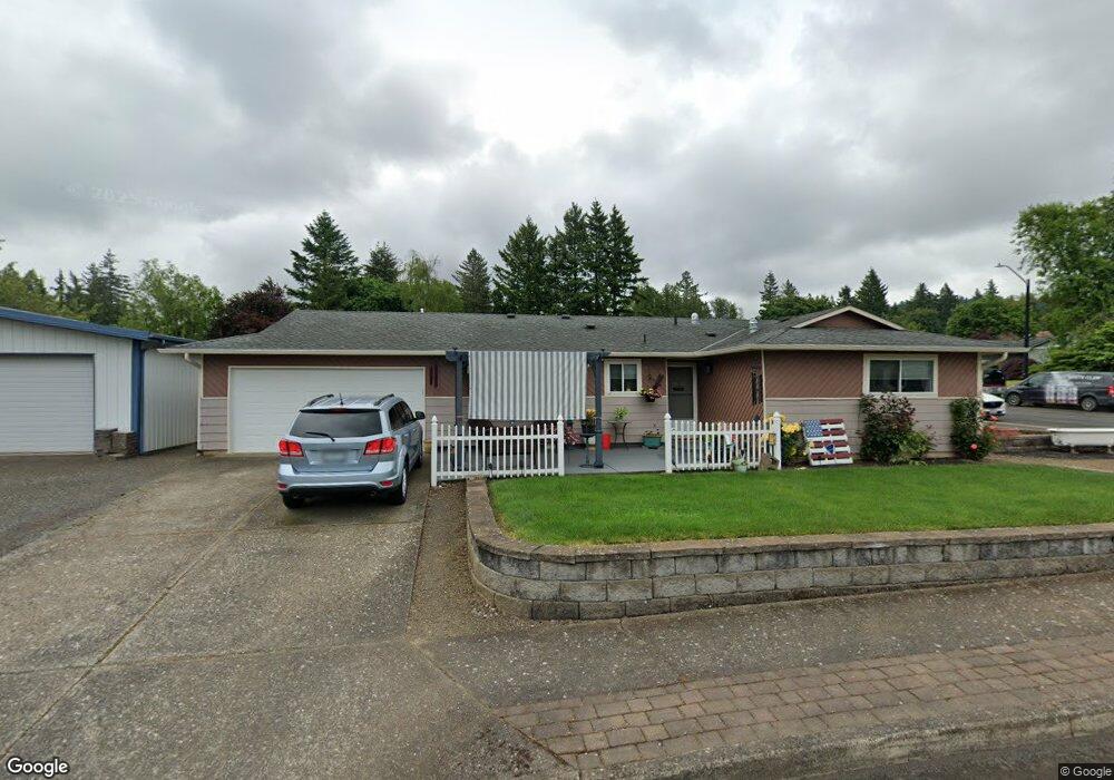
1562 SW Birdsdale Ct Gresham, OR 97080
Southwest Gresham NeighborhoodEstimated Value: $427,000 - $450,607
3
Beds
2
Baths
1,179
Sq Ft
$375/Sq Ft
Est. Value
About This Home
This home is located at 1562 SW Birdsdale Ct, Gresham, OR 97080 and is currently estimated at $441,902, approximately $374 per square foot. 1562 SW Birdsdale Ct is a home located in Multnomah County with nearby schools including Hollydale Elementary School, Dexter McCarty Middle School, and Gresham High School.
Ownership History
Date
Name
Owned For
Owner Type
Purchase Details
Closed on
Feb 4, 2010
Sold by
Southard Russell Lyman
Bought by
Southard Russell Lyman and Southard Carol Jean
Current Estimated Value
Purchase Details
Closed on
Dec 1, 2004
Sold by
Southard Carol J
Bought by
Southard Russell L
Home Financials for this Owner
Home Financials are based on the most recent Mortgage that was taken out on this home.
Original Mortgage
$74,000
Interest Rate
5.65%
Mortgage Type
Stand Alone Refi Refinance Of Original Loan
Create a Home Valuation Report for This Property
The Home Valuation Report is an in-depth analysis detailing your home's value as well as a comparison with similar homes in the area
Home Values in the Area
Average Home Value in this Area
Purchase History
| Date | Buyer | Sale Price | Title Company |
|---|---|---|---|
| Southard Russell Lyman | -- | None Available | |
| Southard Russell L | -- | Ticor Title Insurance Compan |
Source: Public Records
Mortgage History
| Date | Status | Borrower | Loan Amount |
|---|---|---|---|
| Closed | Southard Russell L | $74,000 |
Source: Public Records
Tax History Compared to Growth
Tax History
| Year | Tax Paid | Tax Assessment Tax Assessment Total Assessment is a certain percentage of the fair market value that is determined by local assessors to be the total taxable value of land and additions on the property. | Land | Improvement |
|---|---|---|---|---|
| 2025 | $4,525 | $222,370 | -- | -- |
| 2024 | $4,332 | $215,900 | -- | -- |
| 2023 | $3,947 | $209,620 | $0 | $0 |
| 2022 | $3,836 | $203,520 | $0 | $0 |
| 2021 | $3,740 | $197,600 | $0 | $0 |
| 2020 | $3,519 | $191,850 | $0 | $0 |
| 2019 | $3,427 | $186,270 | $0 | $0 |
| 2018 | $3,268 | $180,850 | $0 | $0 |
| 2017 | $3,135 | $175,590 | $0 | $0 |
| 2016 | $2,764 | $170,480 | $0 | $0 |
| 2015 | $2,705 | $165,520 | $0 | $0 |
| 2014 | $2,639 | $160,700 | $0 | $0 |
Source: Public Records
Map
Nearby Homes
- 1820 SW Heiney Rd
- 1505 SW Battaglia Ave
- 1845 SW 18th Ct
- 2188 SW Binford Lake Pkwy
- 1963 SW Myers Place
- 1897 SW Binford Lake Pkwy
- 1488 SW 17th Ct
- 2307 SW 24th St
- 1421 SW Binford Lake Pkwy
- 3198 SW 16th Cir
- 1396 SW 22nd Terrace
- 3079 SW 22nd St
- 3250 SW Binford Lake Pkwy
- 421 SW Lillyben Ave
- 3308 SW Binford Lake Pkwy
- 2188 SW Wallula Ln
- 975 SW Florence Ct
- 1660 SW 4th St
- 937 SW Florence Ct
- 1743 SW Pleasant View Dr
- 2155 SW 16th Ct
- 1536 SW Birdsdale Ct
- 2148 SW 15th Ct
- 1555 SW Birdsdale Ct
- 1587 SW Birdsdale Ct
- 2131 SW 16th Ct
- 1632 SW Birdsdale Ct
- 1529 SW Birdsdale Ct
- 2118 SW 15th Ct
- 2152 SW 16th Ct
- 1631 SW Birdsdale Ct
- 2231 SW 16th Ct
- 1505 SW Birdsdale Ct
- 2095 SW 16th Ct
- 1600 SW Lillyben Ave
- 2128 SW 16th Ct
- 1649 SW Birdsdale Ct
- 2086 SW 15th Ct
- 1630 SW Lillyben Ave
- 1590 SW Lillyben Ave