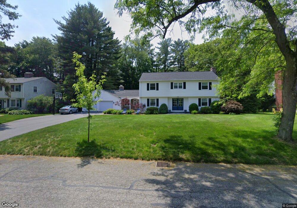
172 Captain Rd Longmeadow, MA 01106
Estimated Value: $666,000 - $725,000
4
Beds
3
Baths
2,467
Sq Ft
$278/Sq Ft
Est. Value
About This Home
This home is located at 172 Captain Rd, Longmeadow, MA 01106 and is currently estimated at $685,182, approximately $277 per square foot. 172 Captain Rd is a home located in Hampden County with nearby schools including Blueberry Hill, Glenbrook Middle School, and Longmeadow High School.
Ownership History
Date
Name
Owned For
Owner Type
Purchase Details
Closed on
Aug 23, 2016
Sold by
Goldberg Andrew M and Goldberg Rachel L
Bought by
Goldberg Andrew M
Current Estimated Value
Home Financials for this Owner
Home Financials are based on the most recent Mortgage that was taken out on this home.
Original Mortgage
$82,800
Outstanding Balance
$37,775
Interest Rate
3.41%
Mortgage Type
Unknown
Estimated Equity
$647,407
Purchase Details
Closed on
Jun 29, 2001
Sold by
Levine Peter M and Levine Melanie
Bought by
Goldberg Andrew M and Goldberg Rachel L
Home Financials for this Owner
Home Financials are based on the most recent Mortgage that was taken out on this home.
Original Mortgage
$165,000
Interest Rate
7.14%
Mortgage Type
Purchase Money Mortgage
Create a Home Valuation Report for This Property
The Home Valuation Report is an in-depth analysis detailing your home's value as well as a comparison with similar homes in the area
Home Values in the Area
Average Home Value in this Area
Purchase History
| Date | Buyer | Sale Price | Title Company |
|---|---|---|---|
| Goldberg Andrew M | -- | -- | |
| Goldberg Andrew M | $320,000 | -- |
Source: Public Records
Mortgage History
| Date | Status | Borrower | Loan Amount |
|---|---|---|---|
| Open | Goldberg Andrew M | $82,800 | |
| Previous Owner | Goldberg Andrew M | $129,000 | |
| Previous Owner | Goldberg Andrew M | $165,000 | |
| Previous Owner | Goldberg Andrew M | $100,000 |
Source: Public Records
Tax History Compared to Growth
Tax History
| Year | Tax Paid | Tax Assessment Tax Assessment Total Assessment is a certain percentage of the fair market value that is determined by local assessors to be the total taxable value of land and additions on the property. | Land | Improvement |
|---|---|---|---|---|
| 2025 | $12,547 | $594,100 | $174,600 | $419,500 |
| 2024 | $12,286 | $594,100 | $174,600 | $419,500 |
| 2023 | $11,300 | $493,000 | $158,900 | $334,100 |
| 2022 | $10,819 | $439,100 | $158,900 | $280,200 |
| 2021 | $10,413 | $420,900 | $151,500 | $269,400 |
| 2020 | $10,226 | $422,400 | $151,500 | $270,900 |
| 2019 | $9,711 | $403,100 | $151,500 | $251,600 |
| 2018 | $8,911 | $366,100 | $176,700 | $189,400 |
| 2017 | $8,701 | $369,000 | $176,700 | $192,300 |
| 2016 | $8,406 | $345,500 | $165,100 | $180,400 |
| 2015 | $8,118 | $343,700 | $163,300 | $180,400 |
Source: Public Records
Map
Nearby Homes
- 37 Captain Rd
- 111 Ashford Rd
- 7 Viscount Rd
- 911 Williams St
- 217 Inverness Ln
- 127 Magnolia Cir
- 120 Inverness Ln
- 85 Inverness Ln
- 49 Wimbleton Dr
- 120 Northfield Rd
- 202 Williamsburg Dr
- 124 Tecumseh Dr
- 151 Wolf Swamp Rd
- 35 Plymouth Rd
- 757 Shaker Rd
- 22 Hawthorne St
- 76 Burbank Rd
- 0 Dennis Rd
- 95 Tedford Dr
- 70 Tennyson Dr
- 160 Captain Rd
- 182 Captain Rd
- 143 Viscount Rd
- 150 Captain Rd
- 153 Viscount Rd
- 192 Captain Rd
- 169 Captain Rd
- 131 Viscount Rd
- 165 Viscount Rd
- 181 Captain Rd
- 202 Captain Rd
- 136 Captain Rd
- 191 Captain Rd
- 147 Captain Rd
- 179 Viscount Rd
- 119 Viscount Rd
- 203 Captain Rd
- 135 Captain Rd
- 112 Captain Rd
- 7 Pendleton Ln