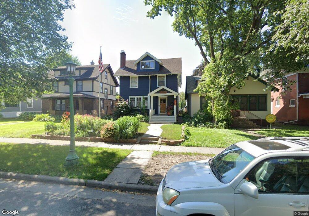
1776 1776 Ashland Ave St. Paul, MN 55104
Union Park NeighborhoodEstimated Value: $560,000 - $635,000
4
Beds
3
Baths
1,971
Sq Ft
$304/Sq Ft
Est. Value
About This Home
This home is located at 1776 1776 Ashland Ave, St. Paul, MN 55104 and is currently estimated at $600,100, approximately $304 per square foot. 1776 1776 Ashland Ave is a home located in Ramsey County with nearby schools including Groveland Park Elementary School, Hidden River Middle School, and Central Senior High School.
Ownership History
Date
Name
Owned For
Owner Type
Purchase Details
Closed on
Aug 31, 2016
Sold by
Dolabi Alexander O
Bought by
Evans Brooke M and Evans Bradley
Current Estimated Value
Home Financials for this Owner
Home Financials are based on the most recent Mortgage that was taken out on this home.
Original Mortgage
$301,750
Outstanding Balance
$241,026
Interest Rate
3.43%
Mortgage Type
New Conventional
Estimated Equity
$359,074
Purchase Details
Closed on
Jan 15, 2015
Sold by
Koentopp William A and Koentopp Christine M
Bought by
Dolabi Alexander O
Home Financials for this Owner
Home Financials are based on the most recent Mortgage that was taken out on this home.
Original Mortgage
$327,064
Interest Rate
3.84%
Mortgage Type
Unknown
Create a Home Valuation Report for This Property
The Home Valuation Report is an in-depth analysis detailing your home's value as well as a comparison with similar homes in the area
Home Values in the Area
Average Home Value in this Area
Purchase History
| Date | Buyer | Sale Price | Title Company |
|---|---|---|---|
| Evans Brooke M | $365,758 | Edina Realty Title Inc | |
| Dolabi Alexander O | $329,500 | Burnet Title |
Source: Public Records
Mortgage History
| Date | Status | Borrower | Loan Amount |
|---|---|---|---|
| Open | Evans Brooke M | $301,750 | |
| Previous Owner | Dolabi Alexander O | $327,064 |
Source: Public Records
Tax History Compared to Growth
Tax History
| Year | Tax Paid | Tax Assessment Tax Assessment Total Assessment is a certain percentage of the fair market value that is determined by local assessors to be the total taxable value of land and additions on the property. | Land | Improvement |
|---|---|---|---|---|
| 2025 | $7,166 | $552,600 | $105,600 | $447,000 |
| 2023 | $7,166 | $464,900 | $105,600 | $359,300 |
| 2022 | $7,004 | $454,700 | $105,600 | $349,100 |
| 2021 | $6,496 | $433,000 | $105,600 | $327,400 |
| 2020 | $6,180 | $416,300 | $105,600 | $310,700 |
| 2019 | $6,462 | $370,900 | $105,600 | $265,300 |
| 2018 | $6,278 | $382,100 | $105,600 | $276,500 |
| 2017 | $5,432 | $382,100 | $105,600 | $276,500 |
| 2016 | $5,618 | $0 | $0 | $0 |
| 2015 | $5,184 | $326,600 | $105,600 | $221,000 |
| 2014 | $4,998 | $0 | $0 | $0 |
Source: Public Records
Map
Nearby Homes
- 1821 Selby Ave
- 1670 Ashland Ave
- 1920 Laurel Ave
- 1798 Marshall Ave
- 1917 Summit Ave Unit 2
- 1836 Marshall Ave
- 1796 Iglehart Ave
- 1671 Marshall Ave
- 1826 Goodrich Ave
- 1926 Lincoln Ave
- 266 Fry St
- 1787 Carroll Ave
- 1540 Ashland Ave Unit 12
- 142 Cambridge St
- 1935 Iglehart Ave
- 2034 Ashland Ave
- 2009 Grand Ave
- 2023 Selby Ave
- 1510 Laurel Ave
- 1611 Carroll Ave
- 1776 Ashland Ave
- 1772 Ashland Ave
- 1782 Ashland Ave
- 1768 Ashland Ave
- 1786 Ashland Ave
- 1764 Ashland Ave
- 1794 Ashland Ave
- 1794 1794 Ashland Ave
- 1756 Ashland Ave
- 1777 Portland Ave
- 1783 Portland Ave
- 1769 Portland Ave
- 1785 Portland Ave
- 1765 Portland Ave
- 1791 Portland Ave
- 1779 Ashland Ave
- 1773 Ashland Ave
- 1783 Ashland Ave
- 1769 Ashland Ave
- 1787 Ashland Ave