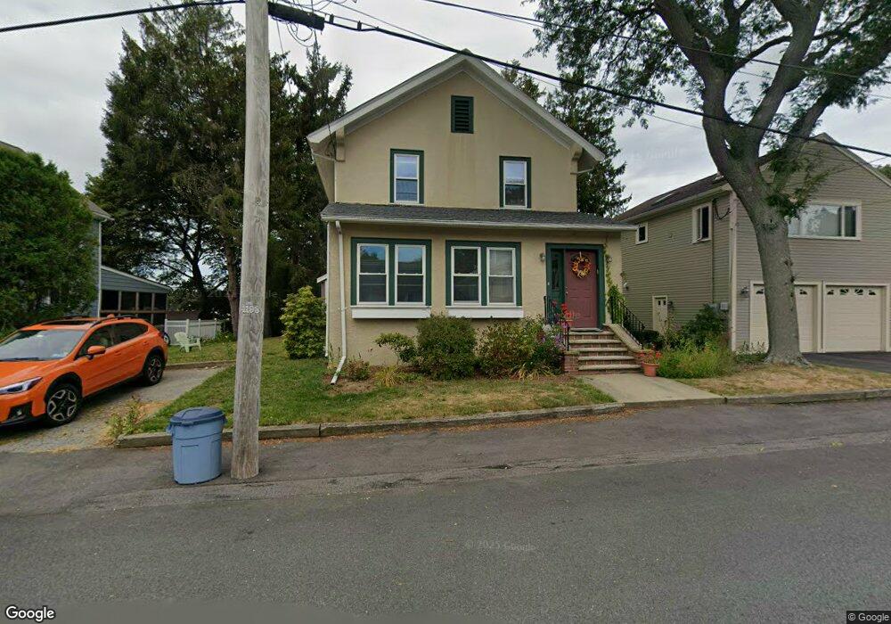
18 Gloucester Ave Gloucester, MA 01930
Central Gloucester NeighborhoodEstimated Value: $644,259
3
Beds
2
Baths
1,900
Sq Ft
$339/Sq Ft
Est. Value
About This Home
This home is located at 18 Gloucester Ave, Gloucester, MA 01930 and is currently estimated at $644,259, approximately $339 per square foot. 18 Gloucester Ave is a home located in Essex County with nearby schools including Plum Cove School, Ralph B O'maley Middle School, and Gloucester High School.
Ownership History
Date
Name
Owned For
Owner Type
Purchase Details
Closed on
Sep 17, 1996
Sold by
Mitchell Joseph and Mitchell Bonnie A
Bought by
Stjohns Episcopal
Current Estimated Value
Home Financials for this Owner
Home Financials are based on the most recent Mortgage that was taken out on this home.
Original Mortgage
$133,600
Outstanding Balance
$7,738
Interest Rate
8.18%
Mortgage Type
Commercial
Estimated Equity
$636,521
Purchase Details
Closed on
Jul 6, 1987
Sold by
Greely Mary E
Bought by
Mitchell Joseph
Home Financials for this Owner
Home Financials are based on the most recent Mortgage that was taken out on this home.
Original Mortgage
$288,000
Interest Rate
10.76%
Mortgage Type
Commercial
Create a Home Valuation Report for This Property
The Home Valuation Report is an in-depth analysis detailing your home's value as well as a comparison with similar homes in the area
Home Values in the Area
Average Home Value in this Area
Purchase History
| Date | Buyer | Sale Price | Title Company |
|---|---|---|---|
| Stjohns Episcopal | $167,000 | -- | |
| Mitchell Joseph | $260,000 | -- |
Source: Public Records
Mortgage History
| Date | Status | Borrower | Loan Amount |
|---|---|---|---|
| Open | Mitchell Joseph | $133,600 | |
| Previous Owner | Mitchell Joseph | $142,000 | |
| Previous Owner | Mitchell Joseph | $155,000 | |
| Previous Owner | Mitchell Joseph | $288,000 |
Source: Public Records
Tax History
| Year | Tax Paid | Tax Assessment Tax Assessment Total Assessment is a certain percentage of the fair market value that is determined by local assessors to be the total taxable value of land and additions on the property. | Land | Improvement |
|---|---|---|---|---|
| 2025 | -- | $703,800 | $207,200 | $496,600 |
| 2024 | -- | $694,000 | $197,400 | $496,600 |
| 2023 | $0 | $609,100 | $176,200 | $432,900 |
| 2022 | $0 | $531,700 | $153,300 | $378,400 |
| 2021 | $0 | $483,200 | $139,300 | $343,900 |
| 2020 | $0 | $479,500 | $139,300 | $340,200 |
| 2019 | $0 | $441,400 | $139,300 | $302,100 |
| 2018 | $0 | $414,100 | $139,300 | $274,800 |
| 2017 | $0 | $393,000 | $132,700 | $260,300 |
| 2016 | -- | $364,400 | $133,200 | $231,200 |
| 2015 | -- | $319,600 | $106,600 | $213,000 |
Source: Public Records
Map
Nearby Homes
- 3 Rockland St
- 6 Monroe Ct
- 15 Harvard St
- 98 Maplewood Ave
- 8 Mystic Ave
- 13 Mystic Ave
- 120 Washington St
- 20 Beacon St
- 20 Beacon St Unit 2
- 20 Beacon St Unit 1
- 9 Cleveland Place
- 13 Leslie o Johnson Rd
- 12 Arthur St
- 33 Maplewood Ave Unit 310
- 40 Sargent St
- 113 Pleasant St
- 145 Essex Ave Unit 402
- 50 Warner St
- 33 Middle St
- 35 Middle St Unit 4
- 20 Gloucester Ave
- 16 Gloucester Ave
- 22 Gloucester Ave
- 14 Gloucester Ave
- 19 Gloucester Ave
- 17 Gloucester Ave
- 21 Gloucester Ave
- 24 Gloucester Ave
- 15 Gloucester Ave
- 23 Gloucester Ave
- 12 Gloucester Ave
- 13 Gloucester Ave
- 26 Gloucester Ave
- 25 Gloucester Ave
- 226 Washington St
- 11 Gloucester Ave
- 10 Gloucester Ave
- 10 Gloucester Ave Unit A
- 10 Gloucester Ave Unit B
- 11 Riverside Ave
Your Personal Tour Guide
Ask me questions while you tour the home.