Estimated Value: $674,453 - $1,340,000
3
Beds
3
Baths
5,721
Sq Ft
$159/Sq Ft
Est. Value
About This Home
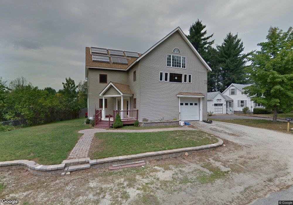
This home is located at 18 Pinecrest Ln, Dover, NH 03820 and is currently estimated at $910,863, approximately $159 per square foot. 18 Pinecrest Ln is a home located in Strafford County with nearby schools including Rollinsford Grade School, Seacoast Charter School, and St Mary Academy.
Ownership History
Date
Name
Owned For
Owner Type
Purchase Details
Closed on
Oct 17, 2022
Sold by
Richard G Sargent Ret
Bought by
Hlavonova Zlata
Current Estimated Value
Purchase Details
Closed on
Nov 2, 2001
Sold by
Economos Frances A
Bought by
Whisnant Owen L
Home Financials for this Owner
Home Financials are based on the most recent Mortgage that was taken out on this home.
Original Mortgage
$114,991
Interest Rate
6.82%
Create a Home Valuation Report for This Property
The Home Valuation Report is an in-depth analysis detailing your home's value as well as a comparison with similar homes in the area
Home Values in the Area
Average Home Value in this Area
Purchase History
| Date | Buyer | Sale Price | Title Company |
|---|---|---|---|
| Hlavonova Zlata | $95,000 | None Available | |
| Whisnant Owen L | $115,900 | -- |
Source: Public Records
Mortgage History
| Date | Status | Borrower | Loan Amount |
|---|---|---|---|
| Previous Owner | Whisnant Owen L | $114,991 |
Source: Public Records
Tax History
| Year | Tax Paid | Tax Assessment Tax Assessment Total Assessment is a certain percentage of the fair market value that is determined by local assessors to be the total taxable value of land and additions on the property. | Land | Improvement |
|---|---|---|---|---|
| 2025 | $10,581 | $644,800 | $163,500 | $481,300 |
| 2024 | $10,581 | $644,800 | $163,500 | $481,300 |
| 2023 | $9,917 | $644,800 | $163,500 | $481,300 |
| 2022 | $9,588 | $644,800 | $163,500 | $481,300 |
| 2021 | $10,101 | $414,300 | $97,400 | $316,900 |
| 2020 | $10,225 | $414,300 | $97,400 | $316,900 |
| 2019 | $9,367 | $414,300 | $97,400 | $316,900 |
| 2018 | $10,001 | $414,300 | $97,400 | $316,900 |
| 2016 | $9,211 | $329,200 | $60,400 | $268,800 |
| 2015 | $9,030 | $329,200 | $60,400 | $268,800 |
| 2014 | $8,639 | $326,000 | $60,400 | $265,600 |
| 2013 | $8,432 | $313,700 | $60,400 | $253,300 |
Source: Public Records
Map
Nearby Homes
- 472 High St
- 0 Indian Brook Rd Unit C
- Lot 0 Page Ave
- 9 Lowell Ave
- 80 Glenwood Ave
- 725 Central Ave Unit 203
- 725 Central Ave Unit LL03
- 725 Central Ave Unit 301
- 725 Central Ave Unit 302
- 725 Central Ave Unit LL01
- 725 Central Ave Unit 304
- 34 Floral Ave Unit 5
- 2 Wolf Ln
- 63 Sixth St
- 249 Clement Rd
- 43 Sixth St Unit A and B
- 47 Central Ave
- 0 4th St Unit 2
- 187 Old Rochester Rd
- 454 Sixth St
Your Personal Tour Guide
Ask me questions while you tour the home.