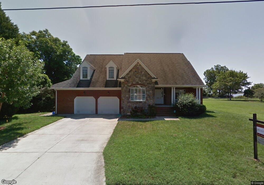
19 Seaview Dr Hampton, VA 23664
Estimated Value: $529,000 - $654,000
4
Beds
3
Baths
3,095
Sq Ft
$189/Sq Ft
Est. Value
About This Home
This home is located at 19 Seaview Dr, Hampton, VA 23664 and is currently estimated at $585,644, approximately $189 per square foot. 19 Seaview Dr is a home located in Hampton City with nearby schools including Jane H. Bryan Elementary School, Benjamin Syms Middle School, and Phoebus High School.
Ownership History
Date
Name
Owned For
Owner Type
Purchase Details
Closed on
Sep 23, 2025
Sold by
Carter Jodi and Washington Jarrod
Bought by
Carter Jodi
Current Estimated Value
Purchase Details
Closed on
Mar 9, 2016
Sold by
Duplessis Errol
Bought by
Carter Jodi and Washington Jarrod
Home Financials for this Owner
Home Financials are based on the most recent Mortgage that was taken out on this home.
Original Mortgage
$415,034
Interest Rate
3.79%
Mortgage Type
VA
Create a Home Valuation Report for This Property
The Home Valuation Report is an in-depth analysis detailing your home's value as well as a comparison with similar homes in the area
Purchase History
| Date | Buyer | Sale Price | Title Company |
|---|---|---|---|
| Carter Jodi | $75,000 | Stewart Title Company | |
| Carter Jodi | $412,000 | Attorney |
Source: Public Records
Mortgage History
| Date | Status | Borrower | Loan Amount |
|---|---|---|---|
| Previous Owner | Carter Jodi | $415,034 |
Source: Public Records
Tax History
| Year | Tax Paid | Tax Assessment Tax Assessment Total Assessment is a certain percentage of the fair market value that is determined by local assessors to be the total taxable value of land and additions on the property. | Land | Improvement |
|---|---|---|---|---|
| 2025 | $1,044 | $590,400 | $187,300 | $403,100 |
| 2024 | $6,790 | $590,400 | $187,300 | $403,100 |
| 2023 | $6,837 | $589,400 | $186,900 | $402,500 |
| 2022 | $6,603 | $559,600 | $181,300 | $378,300 |
| 2021 | $6,339 | $500,700 | $168,200 | $332,500 |
| 2020 | $5,695 | $459,300 | $150,000 | $309,300 |
| 2019 | $5,695 | $459,300 | $150,000 | $309,300 |
| 2018 | $6,184 | $484,400 | $208,500 | $275,900 |
| 2017 | $6,101 | $0 | $0 | $0 |
| 2016 | $6,101 | $484,400 | $0 | $0 |
| 2015 | $6,339 | $0 | $0 | $0 |
| 2014 | $6,090 | $484,400 | $208,500 | $275,900 |
Source: Public Records
Map
Nearby Homes
- 17 Seaview Dr
- 155 Atlantic Ave
- 155 Atlantic Ave Unit C2
- 9 Bayview Ct
- 5B Mallory
- 550 Slater Ave
- 532 Slater Ave
- 714 Grove St
- 2112 E Pembroke Ave
- 1527 Grove St
- 604 Old Buckroe Rd
- 731 Burgess Ave
- 733 Burgess Ave
- 1333 N Mallory St
- 27 E Berkley Dr
- 114 Buckroe Ave
- 6 Langille Ct
- 2013 N Mallory St
- 438 Shelton Rd
- 2013 Whitman Place
Your Personal Tour Guide
Ask me questions while you tour the home.