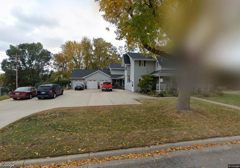
1930 10th St E Glencoe, MN 55336
Estimated Value: $502,735 - $745,000
4
Beds
3
Baths
4,434
Sq Ft
$135/Sq Ft
Est. Value
About This Home
This home is located at 1930 10th St E, Glencoe, MN 55336 and is currently estimated at $597,578, approximately $134 per square foot. 1930 10th St E is a home located in McLeod County with nearby schools including Lincoln Elementary School, Lakeside Elementary School, and Glencoe-Silver Lake Jr. High School.
Ownership History
Date
Name
Owned For
Owner Type
Purchase Details
Closed on
May 9, 2012
Sold by
Janke Margaret A and Janke Myron G
Bought by
Jenkins Timothy M and Jenkins Michaelee K
Current Estimated Value
Home Financials for this Owner
Home Financials are based on the most recent Mortgage that was taken out on this home.
Original Mortgage
$252,000
Outstanding Balance
$171,674
Interest Rate
4%
Estimated Equity
$425,904
Create a Home Valuation Report for This Property
The Home Valuation Report is an in-depth analysis detailing your home's value as well as a comparison with similar homes in the area
Home Values in the Area
Average Home Value in this Area
Purchase History
| Date | Buyer | Sale Price | Title Company |
|---|---|---|---|
| Jenkins Timothy M | -- | Title Mark |
Source: Public Records
Mortgage History
| Date | Status | Borrower | Loan Amount |
|---|---|---|---|
| Open | Jenkins Timothy M | $252,000 |
Source: Public Records
Tax History
| Year | Tax Paid | Tax Assessment Tax Assessment Total Assessment is a certain percentage of the fair market value that is determined by local assessors to be the total taxable value of land and additions on the property. | Land | Improvement |
|---|---|---|---|---|
| 2025 | $8,984 | $657,200 | $94,100 | $563,100 |
| 2024 | $8,254 | $595,000 | $86,000 | $509,000 |
| 2023 | $8,254 | $584,500 | $75,500 | $509,000 |
| 2022 | $8,266 | $514,100 | $68,500 | $445,600 |
| 2021 | $7,166 | $470,000 | $62,000 | $408,000 |
| 2020 | $6,884 | $423,700 | $56,500 | $367,200 |
| 2019 | $6,322 | $398,100 | $51,400 | $346,700 |
| 2018 | $5,828 | $0 | $0 | $0 |
| 2017 | $5,532 | $0 | $0 | $0 |
| 2016 | $5,298 | $0 | $0 | $0 |
| 2015 | $6,078 | $0 | $0 | $0 |
| 2014 | -- | $0 | $0 | $0 |
Source: Public Records
Map
Nearby Homes
- 1801 Pryor Ave N
- 1227 11th St E
- 1412 Elsie Dr N
- 2600 14th St E
- 1519 Ranger Dr N
- 1523 Ranger Dr N
- 1028 13th St E
- 1515 Ranger Dr
- 1512 Ranger Dr N
- 1423 Prairie Ave
- 1235 1st St E
- 1610 Knight Ave N
- 800 Sumac Ln
- 200 Interwood Dr
- 105 Hennepin Ave N
- 526 8th St E
- 707 Ford Ave N
- 614 Elliott Ave N
- 1513 Armstrong Ave N
- 401 20th St W
- 1904 10th St E
- 915 Taylor Ave N
- 1917 9th St E
- 2006 10th St E
- 914 Stevens Ave N
- 1921 10th St E
- 1921 10th St E
- 1931 10th St E
- 2030 2030 10th-Street-e
- 908 Taylor Ave N
- 1921 1921 10th-Street-e
- 1913 9th St E
- 1905 10th St E
- 2018 10th St E
- 2015 9th St E
- 2021 10th St E
- 2019 9th St E
- 913 Stevens Ave N
- 1930 11th St E
- 1914 11th St E
Your Personal Tour Guide
Ask me questions while you tour the home.