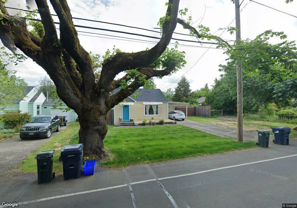
197 Howard Ave Eugene, OR 97404
River Road NeighborhoodEstimated Value: $314,000 - $436,000
2
Beds
1
Bath
933
Sq Ft
$383/Sq Ft
Est. Value
About This Home
This home is located at 197 Howard Ave, Eugene, OR 97404 and is currently estimated at $357,013, approximately $382 per square foot. 197 Howard Ave is a home located in Lane County with nearby schools including Howard Elementary School, Kelly Middle School, and North Eugene High School.
Ownership History
Date
Name
Owned For
Owner Type
Purchase Details
Closed on
Nov 30, 2016
Sold by
Towar Janet E
Bought by
Andrews Beverly A
Current Estimated Value
Home Financials for this Owner
Home Financials are based on the most recent Mortgage that was taken out on this home.
Original Mortgage
$203,700
Outstanding Balance
$163,614
Interest Rate
3.52%
Mortgage Type
New Conventional
Estimated Equity
$193,399
Purchase Details
Closed on
May 20, 2016
Sold by
Wilhelm Rodney Dean and Wilhelm Ava C
Bought by
Towar Janet E
Purchase Details
Closed on
Jun 10, 2008
Sold by
Wilhelm Rodney D
Bought by
Wilhelm Rodney D and Wilhelm Ava C
Purchase Details
Closed on
Oct 16, 2003
Sold by
Wilhelm Rodney D and Wilhelm Dale Allen
Bought by
Wilhelm Rodney D
Create a Home Valuation Report for This Property
The Home Valuation Report is an in-depth analysis detailing your home's value as well as a comparison with similar homes in the area
Home Values in the Area
Average Home Value in this Area
Purchase History
| Date | Buyer | Sale Price | Title Company |
|---|---|---|---|
| Andrews Beverly A | $210,000 | Cascade Title Company | |
| Towar Janet E | $124,500 | Western Title & Escrow Co | |
| Wilhelm Rodney D | -- | None Available | |
| Wilhelm Rodney D | -- | Western Pioneer Title Co |
Source: Public Records
Mortgage History
| Date | Status | Borrower | Loan Amount |
|---|---|---|---|
| Open | Andrews Beverly A | $203,700 |
Source: Public Records
Tax History
| Year | Tax Paid | Tax Assessment Tax Assessment Total Assessment is a certain percentage of the fair market value that is determined by local assessors to be the total taxable value of land and additions on the property. | Land | Improvement |
|---|---|---|---|---|
| 2025 | $2,247 | $133,775 | -- | -- |
| 2024 | $2,223 | $129,879 | -- | -- |
| 2023 | $2,223 | $126,097 | $0 | $0 |
| 2022 | $2,091 | $122,425 | $0 | $0 |
| 2021 | $1,944 | $118,860 | $0 | $0 |
| 2020 | $1,958 | $115,399 | $0 | $0 |
| 2019 | $1,889 | $112,038 | $0 | $0 |
| 2018 | $1,762 | $105,607 | $0 | $0 |
| 2017 | $1,694 | $105,607 | $0 | $0 |
| 2016 | $1,624 | $102,531 | $0 | $0 |
| 2015 | $1,545 | $99,545 | $0 | $0 |
| 2014 | $1,545 | $96,646 | $0 | $0 |
Source: Public Records
Map
Nearby Homes
- 1487 Barton St
- 1483 Barton St
- 1420 Evergreen Dr
- 1360 Andersen Ln
- 389 Maxwell Rd
- 172 Norman Ave
- 154 Norman Ave
- 1314 Dalton Dr
- 1880 Manihi Dr
- 315 Heritage Ave
- 1010 Horn Ln
- 260 Greenleaf Ave
- 1566 Maywood Ave
- 1682 Hemlock St
- 1755 Brentwood Ave
- 401 Sterling Dr
- 2874 Riverwalk Loop
- 788 Cornwall Ave
- 1010 Elkay Dr
- 2709 Riverwalk Loop
Your Personal Tour Guide
Ask me questions while you tour the home.