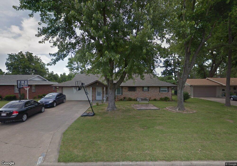
2006 Dee Ave Springdale, AR 72762
Estimated Value: $259,000 - $286,000
3
Beds
2
Baths
1,475
Sq Ft
$184/Sq Ft
Est. Value
About This Home
This home is located at 2006 Dee Ave, Springdale, AR 72762 and is currently estimated at $271,216, approximately $183 per square foot. 2006 Dee Ave is a home located in Washington County with nearby schools including Westwood Elementary School, Southwest Junior High School, and Helen Tyson Middle School.
Ownership History
Date
Name
Owned For
Owner Type
Purchase Details
Closed on
Sep 30, 2005
Sold by
Zornes A Scott and Zornes Cheryl E
Bought by
Adams Kathryn E
Current Estimated Value
Home Financials for this Owner
Home Financials are based on the most recent Mortgage that was taken out on this home.
Original Mortgage
$106,400
Outstanding Balance
$62,844
Interest Rate
7.55%
Mortgage Type
Purchase Money Mortgage
Estimated Equity
$208,372
Purchase Details
Closed on
Dec 18, 1987
Bought by
Scott Zornes A and Scott Scott
Purchase Details
Closed on
Jan 1, 1985
Bought by
Battey Dale R
Create a Home Valuation Report for This Property
The Home Valuation Report is an in-depth analysis detailing your home's value as well as a comparison with similar homes in the area
Purchase History
| Date | Buyer | Sale Price | Title Company |
|---|---|---|---|
| Adams Kathryn E | $133,000 | Waco Title Company | |
| Scott Zornes A | -- | -- | |
| Battey Dale R | -- | -- |
Source: Public Records
Mortgage History
| Date | Status | Borrower | Loan Amount |
|---|---|---|---|
| Open | Adams Kathryn E | $106,400 |
Source: Public Records
Tax History
| Year | Tax Paid | Tax Assessment Tax Assessment Total Assessment is a certain percentage of the fair market value that is determined by local assessors to be the total taxable value of land and additions on the property. | Land | Improvement |
|---|---|---|---|---|
| 2025 | $878 | $46,210 | $14,000 | $32,210 |
| 2024 | $914 | $46,210 | $14,000 | $32,210 |
| 2023 | $951 | $46,210 | $14,000 | $32,210 |
| 2022 | $935 | $29,910 | $6,000 | $23,910 |
| 2021 | $878 | $29,910 | $6,000 | $23,910 |
| 2020 | $821 | $29,910 | $6,000 | $23,910 |
| 2019 | $764 | $21,620 | $6,000 | $15,620 |
| 2018 | $789 | $21,620 | $6,000 | $15,620 |
| 2017 | $779 | $21,620 | $6,000 | $15,620 |
| 2016 | $779 | $21,620 | $6,000 | $15,620 |
| 2015 | $779 | $21,620 | $6,000 | $15,620 |
| 2014 | $779 | $21,620 | $6,000 | $15,620 |
Source: Public Records
Map
Nearby Homes
- 2014 Dee Ave
- 2003 Dee Ave
- 2000 A & B Dee Ave
- 2012 Ina Ave
- 2106 Ina Ave
- 2002 Monticello Ave
- 10 Acres / 3776 McRay Ave
- 1807 Westwood Ave
- 3123 McRay Ave
- 506 Dyer St
- 2704 Mcmillan Dr
- 2007 W Huntsville Ave
- 2700 Mcmillan Dr
- 508 Geneva St
- 1825 McRay Ave
- 609 Dyer St
- 1714 Horseshoe Dr
- 713 Carlton St
- 614 Zachary St
- 603 Thomas Blvd
Your Personal Tour Guide
Ask me questions while you tour the home.