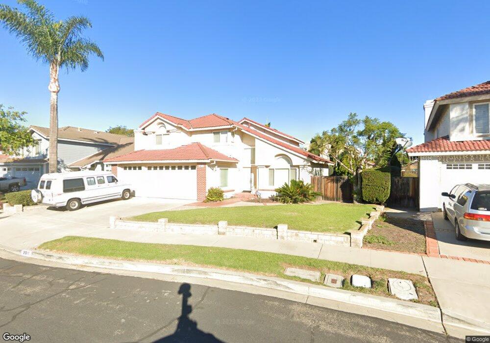
2011 Lennox Ct Oxnard, CA 93030
Cabrillo NeighborhoodEstimated Value: $996,984 - $1,091,000
5
Beds
3
Baths
2,678
Sq Ft
$389/Sq Ft
Est. Value
About This Home
This home is located at 2011 Lennox Ct, Oxnard, CA 93030 and is currently estimated at $1,040,996, approximately $388 per square foot. 2011 Lennox Ct is a home located in Ventura County with nearby schools including Emilie Ritchen Elementary School, Oxnard High School, and Our Redeemer's Nursery School.
Ownership History
Date
Name
Owned For
Owner Type
Purchase Details
Closed on
Nov 18, 2020
Sold by
Miller Charles B and Miller Phyllis J
Bought by
Miller Charles Buck and Miller Phyllis June
Current Estimated Value
Purchase Details
Closed on
Mar 22, 1999
Sold by
Western Federal Svgs Bank
Bought by
Miller Charles B and Miller Phyllis J
Home Financials for this Owner
Home Financials are based on the most recent Mortgage that was taken out on this home.
Original Mortgage
$84,500
Outstanding Balance
$20,958
Interest Rate
7.04%
Estimated Equity
$1,020,038
Purchase Details
Closed on
Nov 9, 1998
Sold by
Angeles Antonio O and Angeles Ofelia H
Bought by
Federal Deposit Insurance Corporation
Create a Home Valuation Report for This Property
The Home Valuation Report is an in-depth analysis detailing your home's value as well as a comparison with similar homes in the area
Home Values in the Area
Average Home Value in this Area
Purchase History
| Date | Buyer | Sale Price | Title Company |
|---|---|---|---|
| Miller Charles Buck | -- | None Available | |
| Miller Charles B | -- | -- | |
| Federal Deposit Insurance Corporation | $208,250 | Fidelity National Title Ins |
Source: Public Records
Mortgage History
| Date | Status | Borrower | Loan Amount |
|---|---|---|---|
| Open | Miller Charles B | $84,500 |
Source: Public Records
Tax History
| Year | Tax Paid | Tax Assessment Tax Assessment Total Assessment is a certain percentage of the fair market value that is determined by local assessors to be the total taxable value of land and additions on the property. | Land | Improvement |
|---|---|---|---|---|
| 2025 | $5,347 | $445,982 | $178,389 | $267,593 |
| 2024 | $5,347 | $437,238 | $174,891 | $262,347 |
| 2023 | $5,151 | $428,665 | $171,462 | $257,203 |
| 2022 | $4,995 | $420,260 | $168,100 | $252,160 |
| 2021 | $4,954 | $412,020 | $164,804 | $247,216 |
| 2020 | $5,044 | $407,797 | $163,115 | $244,682 |
| 2019 | $4,901 | $399,802 | $159,917 | $239,885 |
| 2018 | $4,831 | $391,964 | $156,782 | $235,182 |
| 2017 | $4,640 | $384,279 | $153,708 | $230,571 |
| 2016 | $4,479 | $376,745 | $150,695 | $226,050 |
| 2015 | $4,524 | $371,088 | $148,433 | $222,655 |
| 2014 | $4,474 | $363,821 | $145,526 | $218,295 |
Source: Public Records
Map
Nearby Homes
- 670 Joliet Place
- 1420 Joliet Place
- 1440 Ivywood Dr
- 1721 Joanne Way
- 462 N M St
- 1127 Douglas Ave
- 1131 Janetwood Dr
- 722 W Robert Ave
- 1131 W 2nd St
- 715 W Robert Ave
- 2134 Cold Stream Ct
- 1300 Bluebell St
- 729 Ivywood Dr
- 2100 Norma St
- 307 N F St Unit 102
- 800 S A St
- 1000 Camellia St
- 1920 N H St Unit 251
- 2151 Olga St
- 450 W Roderick Ave
- 2021 Lennox Ct
- 2000 Devonshire Dr
- 1940 Devonshire Dr
- 2031 Lennox Ct
- 1940 Lennox Ct
- 2010 Devonshire Dr
- 2000 Lennox Ct
- 1930 Devonshire Dr
- 2020 Lennox Ct
- 1930 Lennox Ct
- 2041 Lennox Ct
- 2020 Devonshire Dr
- 2030 Lennox Ct
- 1920 Devonshire Dr
- 1920 Lennox Ct
- 1951 Devonshire Dr
- 1911 Lennox Ct
- 2001 Devonshire Dr
- 861 Paddington Place
- 1941 Devonshire Dr
Your Personal Tour Guide
Ask me questions while you tour the home.