
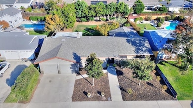
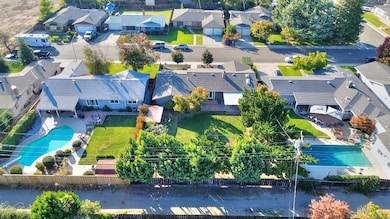
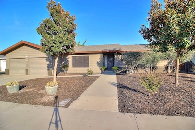
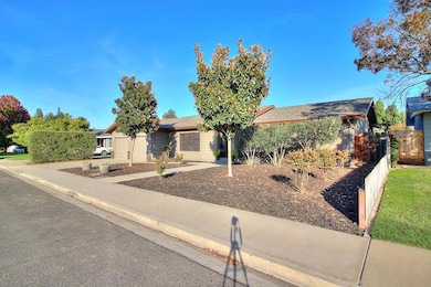
2040 Cumberland Dr Turlock, CA 95382
Estimated payment $2,771/month
Highlights
- Wood Flooring
- Breakfast Area or Nook
- Bathtub with Shower
- No HOA
- 2 Car Attached Garage
- Sunken Living Room
About This Home
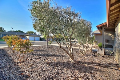
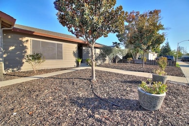
Come and take a look at this amazing home located in desirable East Turlock! Situated on a spacious 10,835 sq. ft. lot, this property offers a variety of fruit trees and a sliding gate for convenient boat or RV access from the back. Inside, the main home features brand-new luxury vinyl flooring and a versatile layout with both a separate family room and living room, plus a large recreational room adding approximately 400 sq. ft. of additional space ideal for a game room, home gym, or entertainment area. The kitchen overlooks the expansive backyard and offers two separate pantries for ample storage. All bedrooms are generous in size with large closets, providing plenty of comfort and functionality. With its prime East Turlock location, spacious lot, and flexible living areas, this home is a true must-see!
Home Details
Home Type
- Single Family
Est. Annual Taxes
- $2,579
Year Built
- Built in 1971 | Remodeled
Lot Details
- 10,833 Sq Ft Lot
- Property is zoned R1
Parking
- 2 Car Attached Garage
Home Design
- Raised Foundation
- Slab Foundation
- Frame Construction
- Composition Roof
Interior Spaces
- 1,644 Sq Ft Home
- 1-Story Property
- Ceiling Fan
- Wood Burning Fireplace
- Raised Hearth
- Stone Fireplace
- Sunken Living Room
- Dining Room with Fireplace
- Laundry in unit
Kitchen
- Breakfast Area or Nook
- Microwave
- Dishwasher
- Tile Countertops
Flooring
- Wood
- Carpet
- Linoleum
- Laminate
Bedrooms and Bathrooms
- 3 Bedrooms
- 2 Full Bathrooms
- Bathtub with Shower
Home Security
- Carbon Monoxide Detectors
- Fire and Smoke Detector
Utilities
- Central Heating and Cooling System
- Water Heater
Community Details
- No Home Owners Association
Listing and Financial Details
- Assessor Parcel Number 072-037-020-000
Map
Home Values in the Area
Average Home Value in this Area
Tax History
| Year | Tax Paid | Tax Assessment Tax Assessment Total Assessment is a certain percentage of the fair market value that is determined by local assessors to be the total taxable value of land and additions on the property. | Land | Improvement |
|---|---|---|---|---|
| 2025 | $2,579 | $247,286 | $76,476 | $170,810 |
| 2024 | $2,530 | $242,438 | $74,977 | $167,461 |
| 2023 | $2,525 | $237,685 | $73,507 | $164,178 |
| 2022 | $2,491 | $233,025 | $72,066 | $160,959 |
| 2021 | $2,453 | $228,456 | $70,653 | $157,803 |
| 2020 | $2,435 | $226,114 | $69,929 | $156,185 |
| 2019 | $2,393 | $221,681 | $68,558 | $153,123 |
| 2018 | $2,389 | $217,335 | $67,214 | $150,121 |
| 2017 | $2,332 | $213,075 | $65,897 | $147,178 |
| 2016 | $2,176 | $208,898 | $64,605 | $144,293 |
| 2015 | $2,157 | $205,761 | $63,635 | $142,126 |
| 2014 | $2,134 | $201,731 | $62,389 | $139,342 |
Property History
| Date | Event | Price | List to Sale | Price per Sq Ft |
|---|---|---|---|---|
| 11/04/2025 11/04/25 | Pending | -- | -- | -- |
| 10/30/2025 10/30/25 | For Sale | $485,000 | -- | $295 / Sq Ft |
Purchase History
| Date | Type | Sale Price | Title Company |
|---|---|---|---|
| Interfamily Deed Transfer | -- | First American Title Company | |
| Individual Deed | $145,500 | Fidelity National Title |
Mortgage History
| Date | Status | Loan Amount | Loan Type |
|---|---|---|---|
| Open | $132,000 | New Conventional | |
| Closed | $130,500 | No Value Available |
Source: MetroList
MLS Number: 225139211
APN: 072-37-20
Disclaimer: Certain information contained herein is derived from information provided by parties other than Homes.com. All information provided is deemed reliable, but is not guaranteed to be accurate and should be independently verified.
![]() IDX information is provided exclusively for personal, non-commercial use, and may not be used for any purpose other than to identify prospective properties consumers may be interested in purchasing. Information is deemed reliable but not guaranteed.
IDX information is provided exclusively for personal, non-commercial use, and may not be used for any purpose other than to identify prospective properties consumers may be interested in purchasing. Information is deemed reliable but not guaranteed.
- 1940 N Berkeley Ave
- 1962 Redhawk Cir
- 1709 Brenda Way
- 1535 Niel Ave
- 0 Hogin Rd Unit MC25187945
- 0 Hogin Rd Unit 225067168
- 1345 Alex Cir
- 1781 N Johnson Rd
- 1950 Simon Dr
- 961 Wakefield Rd
- 1850 Hammond Dr
- 1880 Westminster Ln
- 1015 E Main St
- 2575 Kensington Ct
- 2200 E Tuolumne Rd
- 510 E Minnesota Ave
- 2218 E Tuolumne Rd
- 2351 Lynborough Ct
- 951 E Main St
- 1943 Alex Way
