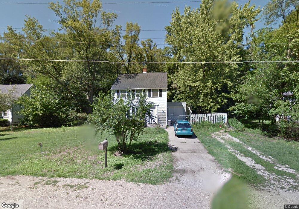
207 Hampton Rd Benton Harbor, MI 49022
Fair Plain NeighborhoodEstimated Value: $150,000 - $164,000
3
Beds
2
Baths
1,152
Sq Ft
$136/Sq Ft
Est. Value
About This Home
This home is located at 207 Hampton Rd, Benton Harbor, MI 49022 and is currently estimated at $157,081, approximately $136 per square foot. 207 Hampton Rd is a home located in Berrien County with nearby schools including Fair Plain Middle School, Benton Harbor High School, and Benton Harbor Charter School Academy.
Ownership History
Date
Name
Owned For
Owner Type
Purchase Details
Closed on
Oct 18, 2011
Sold by
Ashton Phil R and Ashton Lesa M
Bought by
Ashton Phil R and Ashton Lesa M
Current Estimated Value
Home Financials for this Owner
Home Financials are based on the most recent Mortgage that was taken out on this home.
Original Mortgage
$65,500
Outstanding Balance
$6,200
Interest Rate
4.12%
Mortgage Type
New Conventional
Estimated Equity
$150,881
Purchase Details
Closed on
Mar 20, 2000
Purchase Details
Closed on
Nov 4, 1993
Purchase Details
Closed on
Jun 30, 1993
Purchase Details
Closed on
Mar 23, 1993
Purchase Details
Closed on
Mar 4, 1993
Purchase Details
Closed on
May 25, 1990
Purchase Details
Closed on
Oct 8, 1987
Purchase Details
Closed on
Apr 16, 1985
Create a Home Valuation Report for This Property
The Home Valuation Report is an in-depth analysis detailing your home's value as well as a comparison with similar homes in the area
Home Values in the Area
Average Home Value in this Area
Purchase History
| Date | Buyer | Sale Price | Title Company |
|---|---|---|---|
| Ashton Phil R | -- | Chicago Title Of Michigan | |
| -- | $58,000 | -- | |
| -- | $49,500 | -- | |
| -- | $35,000 | -- | |
| -- | -- | -- | |
| -- | $40,900 | -- | |
| -- | $42,900 | -- | |
| -- | -- | -- | |
| -- | -- | -- |
Source: Public Records
Mortgage History
| Date | Status | Borrower | Loan Amount |
|---|---|---|---|
| Open | Ashton Phil R | $65,500 |
Source: Public Records
Tax History Compared to Growth
Tax History
| Year | Tax Paid | Tax Assessment Tax Assessment Total Assessment is a certain percentage of the fair market value that is determined by local assessors to be the total taxable value of land and additions on the property. | Land | Improvement |
|---|---|---|---|---|
| 2025 | $1,671 | $64,900 | $0 | $0 |
| 2024 | $899 | $61,400 | $0 | $0 |
| 2023 | $856 | $59,200 | $0 | $0 |
| 2022 | $815 | $54,700 | $0 | $0 |
| 2021 | $1,470 | $50,900 | $300 | $50,600 |
| 2020 | $1,450 | $50,600 | $0 | $0 |
| 2019 | $1,429 | $46,000 | $300 | $45,700 |
| 2018 | $1,387 | $46,000 | $0 | $0 |
| 2017 | $1,371 | $45,200 | $0 | $0 |
| 2016 | $1,330 | $44,400 | $0 | $0 |
| 2015 | $1,327 | $45,400 | $0 | $0 |
| 2014 | $691 | $41,000 | $0 | $0 |
Source: Public Records
Map
Nearby Homes
- 180 Emery Ave
- 1332 Columbus Ave
- 1267 Broadway
- 1606 Stanley Dr
- 1235 Colfax Ave
- 1301 Superior St
- 449 E Napier Ave
- 1762 Smyers Dr
- 290 Bradford Rd
- 1219 Ogden Ave
- 1097 Pearl St
- 361 E May St
- 379 Western Ave
- 235 Fisk Rd
- 1803 Heath Ct
- 1171 Ogden Ave
- 1880 W Ogden Cir
- 202 Searles Ave
- 304 W May St
- 979 Lavette Ave