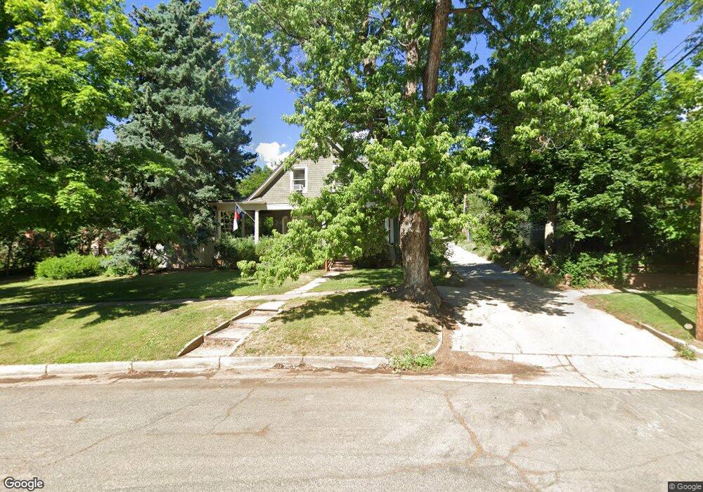
2133 6th St Boulder, CO 80302
Mapleton Hill NeighborhoodEstimated Value: $2,786,242 - $3,882,000
4
Beds
2
Baths
3,313
Sq Ft
$1,003/Sq Ft
Est. Value
About This Home
This home is located at 2133 6th St, Boulder, CO 80302 and is currently estimated at $3,321,311, approximately $1,002 per square foot. 2133 6th St is a home located in Boulder County with nearby schools including Whittier Elementary School, Casey Middle School, and Boulder High School.
Ownership History
Date
Name
Owned For
Owner Type
Purchase Details
Closed on
Jun 15, 2012
Sold by
Corbin Nancy Louise and The Nancy Louise Corbin Living
Bought by
Tranquility Holdings Llc
Current Estimated Value
Purchase Details
Closed on
Dec 18, 2003
Sold by
Corbin Nancy L
Bought by
Corbin Nancy Louise and Nancy Louise Corbin Living Tru
Purchase Details
Closed on
Sep 16, 1986
Bought by
Tranquility Holdings Llc
Purchase Details
Closed on
Dec 31, 1971
Bought by
Tranquility Holdings Llc
Create a Home Valuation Report for This Property
The Home Valuation Report is an in-depth analysis detailing your home's value as well as a comparison with similar homes in the area
Home Values in the Area
Average Home Value in this Area
Purchase History
| Date | Buyer | Sale Price | Title Company |
|---|---|---|---|
| Tranquility Holdings Llc | $1,500,000 | Land Title Guarantee Company | |
| Corbin Nancy Louise | -- | -- | |
| Tranquility Holdings Llc | $187,500 | -- | |
| Tranquility Holdings Llc | -- | -- | |
| Tranquility Holdings Llc | -- | -- |
Source: Public Records
Tax History
| Year | Tax Paid | Tax Assessment Tax Assessment Total Assessment is a certain percentage of the fair market value that is determined by local assessors to be the total taxable value of land and additions on the property. | Land | Improvement |
|---|---|---|---|---|
| 2025 | $17,466 | $185,100 | $130,281 | $54,819 |
| 2024 | $17,466 | $185,100 | $130,281 | $54,819 |
| 2023 | $17,161 | $197,844 | $133,551 | $67,978 |
| 2022 | $15,274 | $163,666 | $100,782 | $62,884 |
| 2021 | $14,568 | $168,375 | $103,682 | $64,693 |
| 2020 | $13,071 | $150,165 | $96,025 | $54,140 |
| 2019 | $12,871 | $150,165 | $96,025 | $54,140 |
| 2018 | $11,711 | $135,079 | $86,904 | $48,175 |
| 2017 | $11,345 | $149,337 | $96,077 | $53,260 |
| 2016 | $8,677 | $100,240 | $76,177 | $24,063 |
| 2015 | $8,217 | $103,878 | $57,710 | $46,168 |
| 2014 | $8,734 | $103,878 | $57,710 | $46,168 |
Source: Public Records
Map
Nearby Homes
- 613 Pine St
- 545 Pearl St
- 620 Pearl St Unit C
- 604 Mapleton Ave
- 745 Highland Ave
- 545 Mapleton Ave
- 2409 5th St
- 643 Mapleton Ave
- 2449 5th St
- 934 Spruce St
- 854 Walnut St Unit D
- 827 Maxwell Ave Unit E
- 715 Arapahoe Ave Unit 2
- 349 W Arapahoe Ln
- 2033 11th St Unit 3, 1
- 534 Dewey Ave
- 900 Portland Place
- 465 Marine St
- 623 Marine St
- 946 Portland Place
Your Personal Tour Guide
Ask me questions while you tour the home.