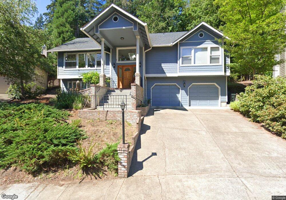
22 Marlboro Ln Eugene, OR 97405
Southeast Eugene NeighborhoodEstimated Value: $666,000 - $728,000
3
Beds
3
Baths
2,258
Sq Ft
$308/Sq Ft
Est. Value
About This Home
This home is located at 22 Marlboro Ln, Eugene, OR 97405 and is currently estimated at $694,779, approximately $307 per square foot. 22 Marlboro Ln is a home located in Lane County with nearby schools including Edgewood Community Elementary School, Spencer Butte Middle School, and South Eugene High School.
Ownership History
Date
Name
Owned For
Owner Type
Purchase Details
Closed on
Mar 19, 2013
Sold by
Rondo Patricia
Bought by
Anderson John W and Anderson Kathleen M
Current Estimated Value
Home Financials for this Owner
Home Financials are based on the most recent Mortgage that was taken out on this home.
Original Mortgage
$224,000
Outstanding Balance
$157,166
Interest Rate
3.49%
Mortgage Type
New Conventional
Estimated Equity
$537,613
Purchase Details
Closed on
Nov 28, 2005
Sold by
Rondo Edmund N and Rondo Patricia A
Bought by
Rondo Patricia and Rondo Edmund
Home Financials for this Owner
Home Financials are based on the most recent Mortgage that was taken out on this home.
Original Mortgage
$198,000
Interest Rate
6.07%
Mortgage Type
New Conventional
Create a Home Valuation Report for This Property
The Home Valuation Report is an in-depth analysis detailing your home's value as well as a comparison with similar homes in the area
Home Values in the Area
Average Home Value in this Area
Purchase History
| Date | Buyer | Sale Price | Title Company |
|---|---|---|---|
| Anderson John W | $280,000 | Multiple | |
| Rondo Patricia | -- | Cascade Title Co |
Source: Public Records
Mortgage History
| Date | Status | Borrower | Loan Amount |
|---|---|---|---|
| Open | Anderson John W | $224,000 | |
| Previous Owner | Rondo Patricia | $198,000 |
Source: Public Records
Tax History
| Year | Tax Paid | Tax Assessment Tax Assessment Total Assessment is a certain percentage of the fair market value that is determined by local assessors to be the total taxable value of land and additions on the property. | Land | Improvement |
|---|---|---|---|---|
| 2025 | $8,097 | $415,582 | -- | -- |
| 2024 | $7,996 | $403,478 | -- | -- |
| 2023 | $7,996 | $391,727 | $0 | $0 |
| 2022 | $7,491 | $380,318 | $0 | $0 |
| 2021 | $7,036 | $369,241 | $0 | $0 |
| 2020 | $7,061 | $358,487 | $0 | $0 |
| 2019 | $6,812 | $348,046 | $0 | $0 |
| 2018 | $5,886 | $328,067 | $0 | $0 |
| 2017 | $5,562 | $328,067 | $0 | $0 |
| 2016 | $5,355 | $318,512 | $0 | $0 |
| 2015 | $5,203 | $309,585 | $0 | $0 |
| 2014 | $5,198 | $306,092 | $0 | $0 |
Source: Public Records
Map
Nearby Homes
- 143 Treehill Loop Unit 143
- 152 Treehill Loop Unit 152
- 151 Treehill Loop Unit 151
- 223 Trailside Loop Unit 223
- 422 Stonewood Dr Unit 422
- 418 Stonewood Dr Unit 418
- 5159 Solar Heights Dr
- 278 Rockridge Ct
- 36 Westbrook Way
- 4734 Brookwood St
- 21 Westbrook Way
- 17 Westbrook Way
- 202 Foxtail Dr
- 296 Woodridge Dr
- 365 Brae Burn Dr
- 4695 Fox Hollow Rd
- 4103 Brae Burn Dr
- 0 Pine View Ct Unit 758820410
- 4295 Ferry St
- 765 Sprague St
- 24 Marlboro Ln
- 26 Marlboro Ln
- 27 Marlboro Ln
- 10 Marlboro Ln
- 28 Marlboro Ln
- 0 Next To 27 Marlboro Unit 21593219
- 0 Next To 27 Marlboro Unit 21096187
- 0 Next To 27 Marlboro Unit 18227188
- 31 Marlboro Ln
- 33 Marlboro Ln
- 33 Marlboro Ln Unit 33
- 0 Spencers Crest 01807 Dr Unit 19107929
- 32 Marlboro Ln
- 79 Marlboro Ln
- 79 Spencers Crest Dr
- 43 Marlboro Ln
- 11 Marlboro Ln
- 0 Spencers Crest 01808 Dr Unit 19487582
- 0 Spencer Crest Dr Unit 1808 22644093
- 0 Spencer Crest Dr Unit 1807 22485719
Your Personal Tour Guide
Ask me questions while you tour the home.