2624 River Rd Cincinnati, OH 45204
East Price Hill NeighborhoodEstimated payment $5,465/month
Highlights
- River View
- 2.58 Acre Lot
- No HOA
- Walnut Hills High School Rated A+
- Partially Wooded Lot
About This Lot
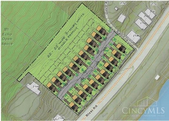
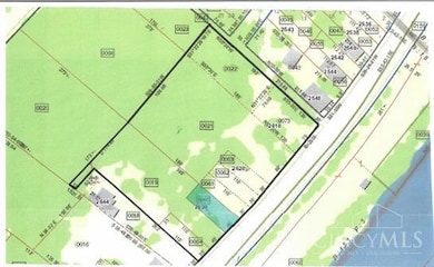
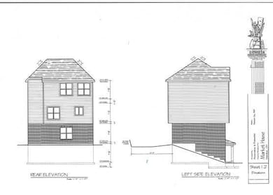
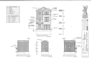
Located just around the Ohio River bend, minutes from Downtown Cincinnati, right on the riverfront at the base of the Mt. Echo Open Space, this 2.58 acre tract currently made up of 9 adjacent parcels poised to become the newest single family riverfront development and the newest place to be in Cincinnati. Our town is poised to take advantage of this riverfront development featuring 18-22 brand new single-family homes with spectacular views of the river and the beautiful Kentucky riverside landscape. But quite possibly the best news is that at this point this site is still a blank canvas that awaits your great ideas and designs. Now is the time to jump in on this property on the ground floor and make it your own.
Listing Agent
Joan Elflein
Ohio Broker Direct License #0000386319 Listed on: 12/01/2025
Property Details
Property Type
- Land
Est. Annual Taxes
- $6,894
Lot Details
- 2.58 Acre Lot
- Partially Wooded Lot
Property Views
- River
- City
Utilities
- Gas Available at Street
- Sewer in Street
Community Details
- No Home Owners Association
Map
Home Values in the Area
Average Home Value in this Area
Tax History
| Year | Tax Paid | Tax Assessment Tax Assessment Total Assessment is a certain percentage of the fair market value that is determined by local assessors to be the total taxable value of land and additions on the property. | Land | Improvement |
|---|---|---|---|---|
| 2025 | $1,138 | $17,574 | $17,574 | -- |
| 2024 | $1,136 | $17,574 | $17,574 | -- |
| 2023 | $1,138 | $17,574 | $17,574 | $0 |
| 2022 | $1,262 | $17,574 | $17,574 | $0 |
| 2021 | $1,234 | $17,574 | $17,574 | $0 |
| 2020 | $1,237 | $17,574 | $17,574 | $0 |
| 2019 | $1,358 | $17,574 | $17,574 | $0 |
| 2018 | $1,359 | $17,574 | $17,574 | $0 |
| 2017 | $1,308 | $17,574 | $17,574 | $0 |
| 2016 | $637 | $8,225 | $8,225 | $0 |
| 2015 | $571 | $8,225 | $8,225 | $0 |
| 2014 | $574 | $8,225 | $8,225 | $0 |
| 2013 | $594 | $8,393 | $8,393 | $0 |
Property History
| Date | Event | Price | List to Sale | Price per Sq Ft |
|---|---|---|---|---|
| 12/01/2025 12/01/25 | For Sale | $950,000 | -- | -- |
Purchase History
| Date | Type | Sale Price | Title Company |
|---|---|---|---|
| Warranty Deed | $6,250 | None Listed On Document | |
| Warranty Deed | $2,000,769 | None Available | |
| Warranty Deed | $2,000,769 | None Listed On Document | |
| Warranty Deed | -- | Attorney | |
| Warranty Deed | $35,000 | Attorney | |
| Warranty Deed | $40,000 | All Ohio Title Agency Inc |
Mortgage History
| Date | Status | Loan Amount | Loan Type |
|---|---|---|---|
| Previous Owner | $32,500 | Seller Take Back |
Source: MLS of Greater Cincinnati (CincyMLS)
MLS Number: 1863238
APN: 151-0003-0021
Disclaimer: Certain information contained herein is derived from information provided by parties other than Homes.com. All information provided is deemed reliable, but is not guaranteed to be accurate and should be independently verified.
![]() The data relating to real estate for sale on this website comes in part from the Broker Reciprocity programs of the MLS of Greater Cincinnati, Inc.. Those listings held by brokerage firms other than Ten-X are marked with the Broker Reciprocity logo and house icon. The properties displayed may not be all of the properties available through Broker Reciprocity.
The data relating to real estate for sale on this website comes in part from the Broker Reciprocity programs of the MLS of Greater Cincinnati, Inc.. Those listings held by brokerage firms other than Ten-X are marked with the Broker Reciprocity logo and house icon. The properties displayed may not be all of the properties available through Broker Reciprocity.
IDX information is provided exclusively for personal, non-commercial use, and may not be used for any purpose other than to identify prospective properties consumers may be interested in purchasing.
Information is deemed reliable but not guaranteed.
Ten-X does not display the entire Cincinnati MLS Broker Reciprocity™ database on this web site. The listings of some real estate brokerage firms have been excluded.
Copyright 2026, MLS of Greater Cincinnati, Inc. All rights reserved
- 377 Cityscape West Dr
- 381 Cityscape West Dr
- 2462 River Rd
- 3114 Murdock Ave
- 454 Grand Ave
- 452 Grand Ave
- 2403 Elberon Ave
- 395 Purcell Ave
- 407 Purcell Ave
- 2414 River Rd
- 435 Purcell Ave
- 3505 Rosecliff Dr
- 607 Elm St
- 514 Considine Ave
- 538 Grand Ave
- 540 Grand Ave
- 552 Grand Ave
- 442 Oak St
- 543 Considine Ave
- 25 Kenner St
- 400 Grand Ave
- 318 Purcell Ave
- 2454 River Rd Unit 2
- 452 Grand Ave
- 464 Grand Ave Unit 1
- 117 1/2 Adela Ave Unit 1
- 117 1/2 Adela Ave
- 117 1/2 Adela Ave Unit 1
- 37 Euclid St Unit 3
- 2415 Maryland Ave Unit 1
- 122 Ash St
- 810 Matson Place
- 105 Ash St Unit SI ID1364141P
- 810 Matson Place Unit 1406
- 2712 Price Ave
- 944 Summit Ave
- 2500 Warsaw Ave Unit 2500 Warsaw Unit 21
- 928 Fairbanks Ave
- 924 Mcpherson Ave
- 459 Pinnacle Way Unit 9202

Ask me questions while you tour the home.