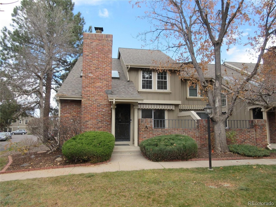


2723 W Long Dr Unit A Littleton, CO 80120
South Littleton NeighborhoodEstimated payment $3,612/month
Highlights
- Primary Bedroom Suite
- Open Floorplan
- Contemporary Architecture
- Runyon Elementary School Rated A-
- Clubhouse
- Property is near public transit
About This Home
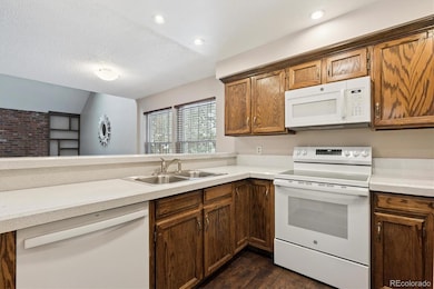
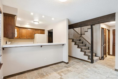
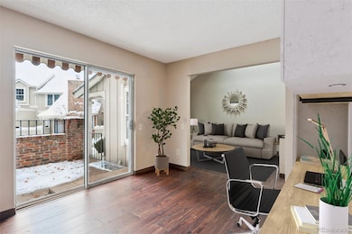
Welcome Home SouthPark One End Unit Fronts And Sides To Greenbelt Located On Cul-De-Sac, Popular Hawthorn Model Featuring Four Bedrooms, Plus Loft, Main Floor Office Area Opening To Private Gated Patio, Four Baths, Main Floor Laundry, Finished Basement Layout For Possible In- Law Apartment. Lots Of Updates Including: New Roof 2024, New Furnace 2024, New Hot Water Heater 2024, New Central Air 2024, Main Floor Wood And Tile Floors, Basement Vinyl Floors Solid Six Panel Doors All Levels, Updated Kitchen Counter Tops, Updated Bath Vanity Tops And Sinks, Two Walk-In Showers Primary Bedroom Bath And Basement Bath, Custom Rod Iron Banister, Updated Double Windows, Power Skylight Blinds Primary Bedroom And Main Floor Living Room, Wood Burning Brick Fireplace. Patio And Upper Level Bedroom Exterior Awnings. Includes All Appliances, Lots Of Extra Storage And Work Bench In The Two Car Attached Garage. Enjoy SouthPark One Community Pool, Tennis/ Pickleball Courts, Club House And Community Trails. Minutes To Mineral Light Rail Station, Aspen Grove Shops And Restaurants. Short Light Rail Ride To Historic Downtown Littleton. Home Is Located In South Suburban Parks And Recreational District, Quick Closing Move In Ready. Home Has Virtual Staging.
Listing Agent
MB Terry Jenni and Associates Brokerage Email: terryjenni@msn.com,303-794-6932 License #040012199 Listed on: 12/09/2025
Open House Schedule
-
Saturday, December 13, 202511:00 am to 1:00 pm12/13/2025 11:00:00 AM +00:0012/13/2025 1:00:00 PM +00:00Add to Calendar
Townhouse Details
Home Type
- Townhome
Est. Annual Taxes
- $3,539
Year Built
- Built in 1983
Lot Details
- End Unit
- 1 Common Wall
- Cul-De-Sac
HOA Fees
- $228 Monthly HOA Fees
Parking
- 2 Car Attached Garage
- Parking Storage or Cabinetry
- Dry Walled Garage
- Epoxy
Home Design
- Contemporary Architecture
- Brick Exterior Construction
- Frame Construction
- Composition Roof
- Wood Siding
- Concrete Perimeter Foundation
Interior Spaces
- 2-Story Property
- Open Floorplan
- Vaulted Ceiling
- Skylights
- Wood Burning Fireplace
- Smart Window Coverings
- Smart Doorbell
- Family Room
- Living Room with Fireplace
- Dining Room
- Den
- Loft
- Bonus Room
- Attic Fan
Kitchen
- Oven
- Range
- Microwave
- Dishwasher
- Disposal
Flooring
- Wood
- Carpet
- Tile
- Vinyl
Bedrooms and Bathrooms
- 4 Bedrooms
- Primary Bedroom Suite
Laundry
- Laundry Room
- Dryer
Finished Basement
- Basement Fills Entire Space Under The House
- 2 Bedrooms in Basement
Home Security
Outdoor Features
- Patio
- Rain Gutters
- Front Porch
Location
- Property is near public transit
Schools
- Runyon Elementary School
- Goddard Middle School
- Heritage High School
Utilities
- Forced Air Heating and Cooling System
- 220 Volts
- 110 Volts
- Natural Gas Connected
- Gas Water Heater
- High Speed Internet
- Phone Available
- Cable TV Available
Listing and Financial Details
- Exclusions: Wall Mirror Located In Living Room, All Art And Pictures On Walls. Personal Belongings.
- Coming Soon on 12/12/25
- Assessor Parcel Number 032212616
Community Details
Overview
- Association fees include reserves, ground maintenance, snow removal, trash, water
- Southpark One Association, Phone Number (720) 633-9772
- Southpark One Community
- Southpark Subdivision
- Greenbelt
Amenities
- Clubhouse
Recreation
- Tennis Courts
- Community Playground
- Trails
Pet Policy
- Dogs and Cats Allowed
Security
- Carbon Monoxide Detectors
- Fire and Smoke Detector
Map
Home Values in the Area
Average Home Value in this Area
Tax History
| Year | Tax Paid | Tax Assessment Tax Assessment Total Assessment is a certain percentage of the fair market value that is determined by local assessors to be the total taxable value of land and additions on the property. | Land | Improvement |
|---|---|---|---|---|
| 2024 | $3,309 | $34,606 | -- | -- |
| 2023 | $3,309 | $34,606 | $0 | $0 |
| 2022 | $2,935 | $28,905 | $0 | $0 |
| 2021 | $2,927 | $28,905 | $0 | $0 |
| 2020 | $2,891 | $29,379 | $0 | $0 |
| 2019 | $2,719 | $29,379 | $0 | $0 |
| 2018 | $2,167 | $24,883 | $0 | $0 |
| 2017 | $2,008 | $24,883 | $0 | $0 |
| 2016 | $1,958 | $23,315 | $0 | $0 |
| 2015 | $1,963 | $23,315 | $0 | $0 |
| 2014 | -- | $19,176 | $0 | $0 |
| 2013 | -- | $18,550 | $0 | $0 |
Purchase History
| Date | Type | Sale Price | Title Company |
|---|---|---|---|
| Deed | $184,900 | None Available | |
| Interfamily Deed Transfer | -- | -- | |
| Deed | -- | -- | |
| Deed | -- | -- | |
| Deed | -- | -- |
Mortgage History
| Date | Status | Loan Amount | Loan Type |
|---|---|---|---|
| Open | $147,900 | New Conventional |
Source: REcolorado®
MLS Number: 5637006
APN: 2077-32-1-05-037
Disclaimer: Certain information contained herein is derived from information provided by parties other than Homes.com. All information provided is deemed reliable, but is not guaranteed to be accurate and should be independently verified.
![]() The content relating to real estate for sale in this Web site comes in part from the Internet Data eXchange (“IDX”) program of METROLIST, INC., DBA RECOLORADO®. Real estate listings held by brokers other than Ten-X are marked with the IDX Logo. This information is being provided for the consumers’ personal, non-commercial use and may not be used for any other purpose. All information subject to change and should be independently verified.
The content relating to real estate for sale in this Web site comes in part from the Internet Data eXchange (“IDX”) program of METROLIST, INC., DBA RECOLORADO®. Real estate listings held by brokers other than Ten-X are marked with the IDX Logo. This information is being provided for the consumers’ personal, non-commercial use and may not be used for any other purpose. All information subject to change and should be independently verified.
This publication is designed to provide information with regard to the subject matter covered. It is displayed with the understanding that the publisher and authors are not engaged in rendering real estate, legal, accounting, tax, or other professional services and that the publisher and authors are not offering such advice in this publication. If real estate, legal, or other expert assistance is required, the services of a competent, professional person should be sought.
The information contained in this publication is subject to change without notice. METROLIST, INC., DBA RECOLORADO MAKES NO WARRANTY OF ANY KIND WITH REGARD TO THIS MATERIAL, INCLUDING, BUT NOT LIMITED TO, THE IMPLIED WARRANTIES OF MERCHANTABILITY AND FITNESS FOR A PARTICULAR PURPOSE. METROLIST, INC., DBA RECOLORADO SHALL NOT BE LIABLE FOR ERRORS CONTAINED HEREIN OR FOR ANY DAMAGES IN CONNECTION WITH THE FURNISHING, PERFORMANCE, OR USE OF THIS MATERIAL.
PUBLISHER’S NOTICE: All real estate advertised herein is subject to the Federal Fair Housing Act and the Colorado Fair Housing Act, which Acts make it illegal to make or publish any advertisement that indicates any preference, limitation, or discrimination based on race, color, religion, sex, handicap, familial status, or national origin.
METROLIST, INC., DBA RECOLORADO will not knowingly accept any advertising for real estate that is in violation of the law. All persons are hereby informed that all dwellings advertised are available on an equal opportunity basis.
© 2025 METROLIST, INC., DBA RECOLORADO® – All Rights Reserved. 6455 S. Yosemite St., Suite 500 Greenwood Village, CO 80111 USA
ALL RIGHTS RESERVED WORLDWIDE. No part of this publication may be reproduced, adapted, translated, stored in a retrieval system or transmitted in any form or by any means, electronic, mechanical, photocopying, recording, or otherwise, without the prior written permission of the publisher. The information contained herein including but not limited to all text, photographs, digital images, virtual tours, may be seeded and monitored for protection and tracking.
- 7761 S Curtice Dr Unit C
- 2783 W Long Dr Unit B
- 2743 W Long Dr Unit B
- 7707 S Curtice Way Unit D
- 2995 W Long Ct Unit B
- 2885 W Long Cir Unit B
- 2906 W Long Cir Unit B
- 7909 S Bemis St
- 2443 W Sunset Dr
- 7420 S Houstoun Waring Cir
- 7391 S Costilla St
- 2021 W Nantucket Ct
- 7720 S Irving St
- 7724 S Irving St
- 7734 S Irving St
- 7732 S Irving St
- 7740 S Irving St
- 7738 S Irving St
- Rosedale Plan at ParkVue on the Platte - Heights Collection
- Sloan Plan at ParkVue on the Platte - Altitude Collection
- 3004 W Long Dr Unit A
- 7724 S Nevada Dr
- 7830 S Hill Cir
- 8300 Erickson Blvd
- 2503 Primo Rd
- 8388 Donati Terrace
- 8418 Rizza St Unit A
- 8555 Belle Dr
- 3 Wild Plum Ct
- 501 W Mineral Ave
- 7125 S Polo Ridge Dr
- 4560 W Mineral Dr
- 7501 S Utica Dr
- 8857 Creekside Way
- 7150 S Platte Canyon Rd
- 6419 S Vinewood St
- 600 W County Line Rd
- 1700 Shea Center Dr
- 1360 Martha St
- 7144 S Acoma Ct
