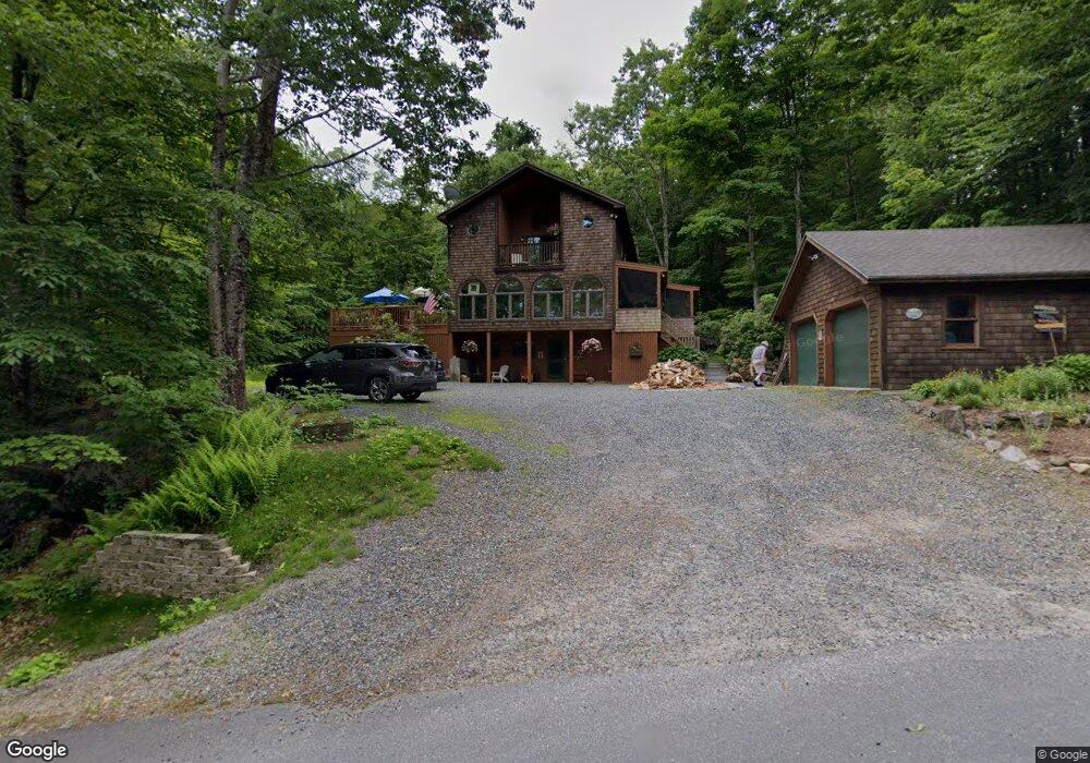
294 Bay Point Rd Newbury, NH 03255
Estimated Value: $962,000 - $1,013,494
3
Beds
3
Baths
2,373
Sq Ft
$413/Sq Ft
Est. Value
About This Home
This home is located at 294 Bay Point Rd, Newbury, NH 03255 and is currently estimated at $979,498, approximately $412 per square foot. 294 Bay Point Rd is a home located in Merrimack County with nearby schools including Kearsarge Regional Elementary School at Bradford, Kearsarge Regional Middle School, and Kearsarge Regional High School.
Ownership History
Date
Name
Owned For
Owner Type
Purchase Details
Closed on
Dec 31, 2002
Sold by
Oneil Roderick
Bought by
Prince Daniel E and Prince Gail E
Current Estimated Value
Home Financials for this Owner
Home Financials are based on the most recent Mortgage that was taken out on this home.
Original Mortgage
$260,000
Outstanding Balance
$110,919
Interest Rate
6.02%
Estimated Equity
$868,579
Create a Home Valuation Report for This Property
The Home Valuation Report is an in-depth analysis detailing your home's value as well as a comparison with similar homes in the area
Home Values in the Area
Average Home Value in this Area
Purchase History
| Date | Buyer | Sale Price | Title Company |
|---|---|---|---|
| Prince Daniel E | $325,000 | -- |
Source: Public Records
Mortgage History
| Date | Status | Borrower | Loan Amount |
|---|---|---|---|
| Open | Prince Daniel E | $260,000 |
Source: Public Records
Tax History Compared to Growth
Tax History
| Year | Tax Paid | Tax Assessment Tax Assessment Total Assessment is a certain percentage of the fair market value that is determined by local assessors to be the total taxable value of land and additions on the property. | Land | Improvement |
|---|---|---|---|---|
| 2024 | $8,291 | $635,300 | $267,600 | $367,700 |
| 2023 | $8,291 | $635,300 | $267,600 | $367,700 |
| 2022 | $7,230 | $635,300 | $267,600 | $367,700 |
| 2021 | $7,230 | $635,300 | $267,600 | $367,700 |
| 2020 | $7,350 | $444,900 | $173,900 | $271,000 |
| 2019 | $7,065 | $444,900 | $173,900 | $271,000 |
| 2018 | $6,896 | $444,900 | $173,900 | $271,000 |
| 2017 | $6,989 | $444,900 | $173,900 | $271,000 |
| 2016 | $7,141 | $444,900 | $173,900 | $271,000 |
| 2015 | $7,188 | $441,500 | $173,900 | $267,600 |
| 2014 | $6,839 | $441,500 | $173,900 | $267,600 |
| 2013 | $6,592 | $441,500 | $173,900 | $267,600 |
Source: Public Records
Map
Nearby Homes
- 12 Shadow Ln
- 30 Greystone Ln
- 8 Snow Rd
- 0 Edgemont Rd Unit 44
- 33 Chandler Brook Rd
- 315 Edgemont Rd
- 274 Edgemont Rd
- 1386 Route 103
- 20 Edgemont Landing Rd
- 38 New Province Rd
- 81 Lakewood Manor Rd
- 37 Baker Hill Rd
- 253 Lake Ave
- 14 Sugarhouse Ln
- 616 New Hampshire Route 103
- 91 Chalk Pond Rd
- 0 Lakewood Manor Rd Unit 467
- 14 Lake Ave Unit 1
- 552 Route 103
- 55 High St
- 310 Bay Point Rd
- 285 Bay Point Rd
- 283 Bay Point Rd
- 276 Bay Point Rd
- 279 Bay Point Rd
- 29 Greystone Ln
- 31 Greystone
- 15 Greystone Ln
- 269 Bay Point Rd
- 260 Bay Point Rd
- 295 Bay Point Rd
- 295 Bay Point Rd Unit 6/170/443 and 006/
- 267 Bay Point Rd
- 11 Greystone Ln
- 258 Bay Point Rd
- 263 Bay Point Rd
- 312 Bay Point Rd
- 24 Shadow Ln
- 9 Shadow Ln
- 255 Bay Point Rd