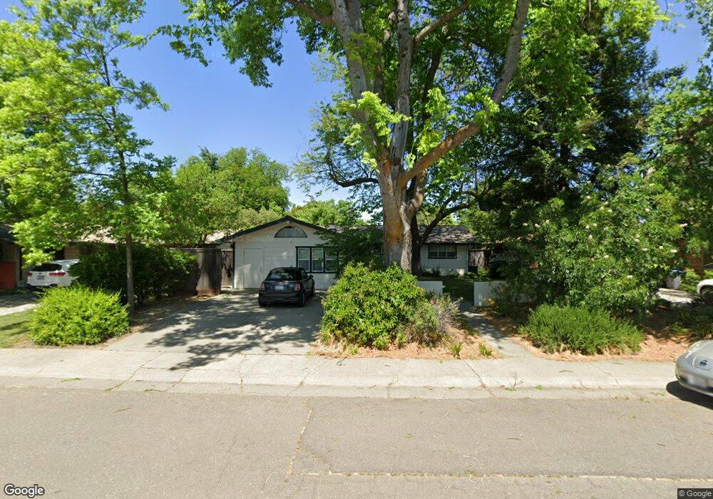
315 12th St Davis, CA 95616
Central Davis NeighborhoodEstimated Value: $754,307 - $1,021,000
3
Beds
3
Baths
1,763
Sq Ft
$487/Sq Ft
Est. Value
About This Home
This home is located at 315 12th St, Davis, CA 95616 and is currently estimated at $858,827, approximately $487 per square foot. 315 12th St is a home located in Yolo County with nearby schools including North Davis Elementary School, Oliver Wendell Holmes Junior High School, and Davis Senior High School.
Ownership History
Date
Name
Owned For
Owner Type
Purchase Details
Closed on
Nov 14, 2001
Sold by
Talley Elaine and Roy Jeffrey
Bought by
Roy Jeffrey Porter and Talley Elaine Helena
Current Estimated Value
Purchase Details
Closed on
May 28, 1998
Sold by
Stanley M Davis Co
Bought by
Roy Jeffrey and Talley Elaine
Home Financials for this Owner
Home Financials are based on the most recent Mortgage that was taken out on this home.
Original Mortgage
$100,000
Outstanding Balance
$20,145
Interest Rate
7.13%
Mortgage Type
Credit Line Revolving
Estimated Equity
$838,682
Purchase Details
Closed on
Apr 28, 1997
Sold by
Oakshade Development
Bought by
Roy Jeffrey and Talley Elaine
Purchase Details
Closed on
Dec 23, 1994
Sold by
Talley Elaine
Bought by
Roy Jeffrey and Talley Elaine
Create a Home Valuation Report for This Property
The Home Valuation Report is an in-depth analysis detailing your home's value as well as a comparison with similar homes in the area
Home Values in the Area
Average Home Value in this Area
Purchase History
| Date | Buyer | Sale Price | Title Company |
|---|---|---|---|
| Roy Jeffrey Porter | -- | -- | |
| Roy Jeffrey | $125,500 | Placer Title Company | |
| Roy Jeffrey | $94,000 | Placer Title Company | |
| Roy Jeffrey | -- | -- |
Source: Public Records
Mortgage History
| Date | Status | Borrower | Loan Amount |
|---|---|---|---|
| Open | Roy Jeffrey | $100,000 |
Source: Public Records
Tax History
| Year | Tax Paid | Tax Assessment Tax Assessment Total Assessment is a certain percentage of the fair market value that is determined by local assessors to be the total taxable value of land and additions on the property. | Land | Improvement |
|---|---|---|---|---|
| 2025 | $4,709 | $300,203 | $121,960 | $178,243 |
| 2023 | $4,709 | $288,548 | $117,225 | $171,323 |
| 2022 | $4,498 | $282,891 | $114,927 | $167,964 |
| 2021 | $4,380 | $277,345 | $112,674 | $164,671 |
| 2020 | $4,303 | $274,502 | $111,519 | $162,983 |
| 2019 | $4,033 | $269,121 | $109,333 | $159,788 |
| 2018 | $3,858 | $272,102 | $107,190 | $164,912 |
| 2017 | $3,773 | $266,768 | $105,089 | $161,679 |
| 2016 | $3,627 | $261,538 | $103,029 | $158,509 |
| 2015 | $3,506 | $257,611 | $101,482 | $156,129 |
| 2014 | $3,506 | $252,566 | $99,495 | $153,071 |
Source: Public Records
Map
Nearby Homes
- 615 11th St
- 1018 Ovejas Ave
- 1009 Ovejas Ave Unit 11
- 717 D St
- 405 7th St
- 1302 Oak Ave
- 646 F St
- 825 Oak Ave
- 528 Rutgers Dr
- 704 6th St
- 53 College Park
- 2007 Alta Loma St
- 2181 Bella Casa St
- 1661 Spring St Unit 443
- 1661 Spring St Unit 424
- 1661 Spring St Unit 444
- 1661 Spring St Unit 341
- 1661 Spring St Unit 433
- 2128 Bueno Dr Unit 18
- 601 J St
Your Personal Tour Guide
Ask me questions while you tour the home.