


3
Beds
2
Baths
1,669
Sq Ft
$250/mo
HOA Fee
Highlights
- Stainless Steel Appliances
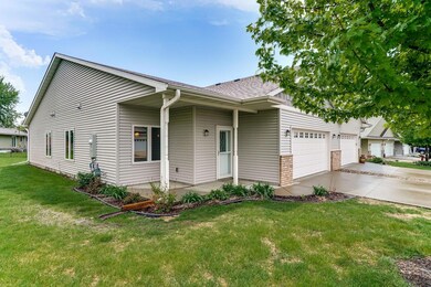
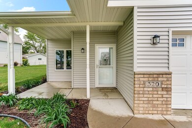
- Front Porch
- Living Room
- Watertown-Mayer Elementary School Rated 9+
- 2 Car Attached Garage
- 1-Story Property
About This Home
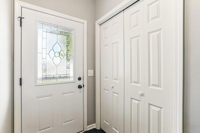
As of June 2025Looking for a home that’s as stylish as it is practical? This beautifully designed 3-bedroom, 2-bath end-unit townhome offers easy single-level living with an elevated, modern feel. From the moment you step inside, you'll notice the thoughtfully designed open layout that maximizes both flow and functionality. The spacious kitchen features gleaming granite countertops, stainless steel appliances, and a convenient breakfast bar—ideal for everything from morning coffee to entertaining guests. The primary bedroom is set apart for added privacy and includes a walk-in closet and a sleek 3/4 en-suite bath. With no stairs to navigate and an efficient layout that doesn't compromise on space or style, this home delivers the low-maintenance lifestyle you’ve been looking for.
Townhouse Details
Home Type
- Townhome
Est. Annual Taxes
- $2,935
Year Built
- Built in 2018
HOA Fees
- $250 Monthly HOA Fees
Parking
- 2 Car Attached Garage
- Heated Garage
- Insulated Garage
- Garage Door Opener
Interior Spaces
- 1,669 Sq Ft Home
- 1-Story Property
- Living Room
- Dining Room
Kitchen
- Range<<rangeHoodToken>>
- <<microwave>>
- Dishwasher
- Stainless Steel Appliances
- Disposal
Bedrooms and Bathrooms
- 3 Bedrooms
Laundry
- Dryer
- Washer
Utilities
- Forced Air Heating and Cooling System
- 200+ Amp Service
- Water Filtration System
Additional Features
- Air Exchanger
- Front Porch
- 3,049 Sq Ft Lot
Community Details
- Association fees include maintenance structure, hazard insurance, lawn care, ground maintenance, professional mgmt, snow removal
- Sunset Meadows Association, Phone Number (612) 865-6335
- Sunset Meadows Subdivision
Listing and Financial Details
- Assessor Parcel Number 507250480
Ownership History
Date
Name
Owned For
Owner Type
Purchase Details
Listed on
May 16, 2025
Closed on
Jun 24, 2025
Sold by
Kl Mn 6 Llc
Bought by
Podratz Brian and Podratz Terry
Seller's Agent
Mitchel Herian
Kris Lindahl Real Estate
Buyer's Agent
Charlotte Andres
Referral Realty
List Price
$300,000
Sold Price
$315,000
Premium/Discount to List
$15,000
5%
Views
4
Home Financials for this Owner
Home Financials are based on the most recent Mortgage that was taken out on this home.
Avg. Annual Appreciation
389.20%
Original Mortgage
$235,000
Interest Rate
6.67%
Mortgage Type
Construction
Purchase Details
Listed on
May 16, 2025
Closed on
Apr 29, 2025
Sold by
Trucke Ryan
Bought by
Kl Mn 6 Llc
Seller's Agent
Mitchel Herian
Kris Lindahl Real Estate
Buyer's Agent
Charlotte Andres
Referral Realty
List Price
$300,000
Sold Price
$315,000
Premium/Discount to List
$15,000
5%
Views
4
Home Financials for this Owner
Home Financials are based on the most recent Mortgage that was taken out on this home.
Original Mortgage
$235,000
Interest Rate
6.67%
Mortgage Type
Construction
Purchase Details
Closed on
Nov 13, 2024
Sold by
Ramachandran Harish and Venkateswaran Vidya
Bought by
Ramachandran Harish and Venkateswaran Vidya
Purchase Details
Closed on
Jun 29, 2018
Sold by
Maetzold Homes Inc
Bought by
Trucke Ryan
Purchase Details
Closed on
Jun 5, 2015
Sold by
Zaf Real Estate Llc
Bought by
Maetzold Homes Inc
Home Financials for this Owner
Home Financials are based on the most recent Mortgage that was taken out on this home.
Original Mortgage
$29,700
Interest Rate
3.63%
Mortgage Type
Unknown
Purchase Details
Closed on
Dec 17, 2014
Sold by
Security Bank Trust Co
Bought by
Zaf Real Estate Llc
Purchase Details
Closed on
Feb 17, 2012
Sold by
Sunset Meadows Llc
Bought by
Security Bank Waconia
Similar Homes in Mayer, MN
Create a Home Valuation Report for This Property
The Home Valuation Report is an in-depth analysis detailing your home's value as well as a comparison with similar homes in the area
Home Values in the Area
Average Home Value in this Area
Purchase History
| Date | Type | Sale Price | Title Company |
|---|---|---|---|
| Warranty Deed | $315,000 | Minnetonka Title | |
| Warranty Deed | $235,000 | None Listed On Document | |
| Deed | -- | None Listed On Document | |
| Warranty Deed | $224,621 | Title Mark Llc | |
| Warranty Deed | $39,600 | Title Mark | |
| Limited Warranty Deed | $143,000 | Title Mark | |
| Warranty Deed | -- | Title Mark |
Source: Public Records
Mortgage History
| Date | Status | Loan Amount | Loan Type |
|---|---|---|---|
| Previous Owner | $235,000 | Construction | |
| Previous Owner | $29,700 | Unknown |
Source: Public Records
Property History
| Date | Event | Price | Change | Sq Ft Price |
|---|---|---|---|---|
| 06/24/2025 06/24/25 | Sold | $315,000 | 0.0% | $189 / Sq Ft |
| 05/19/2025 05/19/25 | Off Market | $315,000 | -- | -- |
| 05/17/2025 05/17/25 | For Sale | $300,000 | -- | $180 / Sq Ft |
Source: NorthstarMLS
Tax History Compared to Growth
Tax History
| Year | Tax Paid | Tax Assessment Tax Assessment Total Assessment is a certain percentage of the fair market value that is determined by local assessors to be the total taxable value of land and additions on the property. | Land | Improvement |
|---|---|---|---|---|
| 2025 | $2,970 | $297,300 | $70,000 | $227,300 |
| 2024 | $3,094 | $267,300 | $40,000 | $227,300 |
| 2023 | $3,400 | $276,800 | $40,000 | $236,800 |
| 2022 | $3,192 | $288,600 | $40,000 | $248,600 |
| 2021 | $2,948 | $208,600 | $33,200 | $175,400 |
| 2020 | $2,636 | $208,600 | $33,200 | $175,400 |
| 2019 | $388 | $20,600 | $20,600 | $0 |
| 2018 | $342 | $20,600 | $20,600 | $0 |
| 2017 | $350 | $18,700 | $18,700 | $0 |
| 2016 | $362 | $18,400 | $0 | $0 |
| 2015 | $372 | $18,000 | $0 | $0 |
| 2014 | $372 | $17,200 | $0 | $0 |
Source: Public Records
Agents Affiliated with this Home
-
Mitchel Herian
Seller's Agent in 2025
Mitchel Herian
Kris Lindahl Real Estate
(763) 219-3083
1 in this area
262 Total Sales
-
Charlotte Andres
C
Buyer's Agent in 2025
Charlotte Andres
Referral Realty
(612) 559-5919
1 in this area
16 Total Sales
Map
Source: NorthstarMLS
MLS Number: 6721046
APN: 50.7250480
Disclaimer: Certain information contained herein is derived from information provided by parties other than Homes.com. All information provided is deemed reliable, but is not guaranteed to be accurate and should be independently verified.
![]() Based on information submitted to the MLS GRID. All data is obtained from various sources and may not have been verified by broker or MLS GRID. Supplied Open House Information is subject to change without notice. All information should be independently reviewed and verified for accuracy. Properties may or may not be listed by the office/agent presenting the information. Some IDX listings have been excluded from this website.
Based on information submitted to the MLS GRID. All data is obtained from various sources and may not have been verified by broker or MLS GRID. Supplied Open House Information is subject to change without notice. All information should be independently reviewed and verified for accuracy. Properties may or may not be listed by the office/agent presenting the information. Some IDX listings have been excluded from this website.
The Digital Millennium Copyright Act of 1998, 17 U.S.C. § 512 (the “DMCA”) provides recourse for copyright owners who believe that material appearing on the Internet infringes their rights under U.S. copyright law. If you believe in good faith that any content or material made available in connection with our website or services infringes your copyright, you (or your agent) may send us a notice requesting that the content or material be removed, or access to it blocked.
Notices must be sent in writing by email to DMCAnotice@MLSGrid.com.
The DMCA requires that your notice of alleged copyright infringement include the following information:
(1) description of the copyrighted work that is the subject of claimed infringement;
(2) description of the alleged infringing content and information sufficient to permit us to locate the content;
(3) contact information for you, including your address, telephone number and email address;
(4) a statement by you that you have a good faith belief that the content in the manner complained of is not authorized by the copyright owner, or its agent, or by the operation of any law;
(5) a statement by you, signed under penalty of perjury, that the information in the notification is accurate and that you have the authority to enforce the copyrights that are claimed to be infringed; and
(6) a physical or electronic signature of the copyright owner or a person authorized to act on the copyright owner’s behalf. Failure to include all of the above information may result in the delay of the processing of your complaint.
Nearby Homes
- 180 Morning Dr
- 190 Morning Dr
- 2074 River Bend Trail
- 1202 Hidden Creek Blvd
- 2083 River Bend Trail
- 2091 River Bend Trail
- 2095 River Bend Trail
- 2103 River Bend Trail
- 2102 River Bend Trail
- 2107 River Bend Trail
- 2119 River Bend Trail
- 1503 Hidden Trail
- 2127 River Bend Trail
- 2301 Hickory Ln
- 1623 Hidden Trail
- 2578 Schumacher Ct
- 5162 Prairie Point
- 5146 Harvest Curve
- XXX 62nd St
- 5875 Highway 25