Estimated Value: $436,000 - $469,000
4
Beds
4
Baths
2,544
Sq Ft
$175/Sq Ft
Est. Value
About This Home
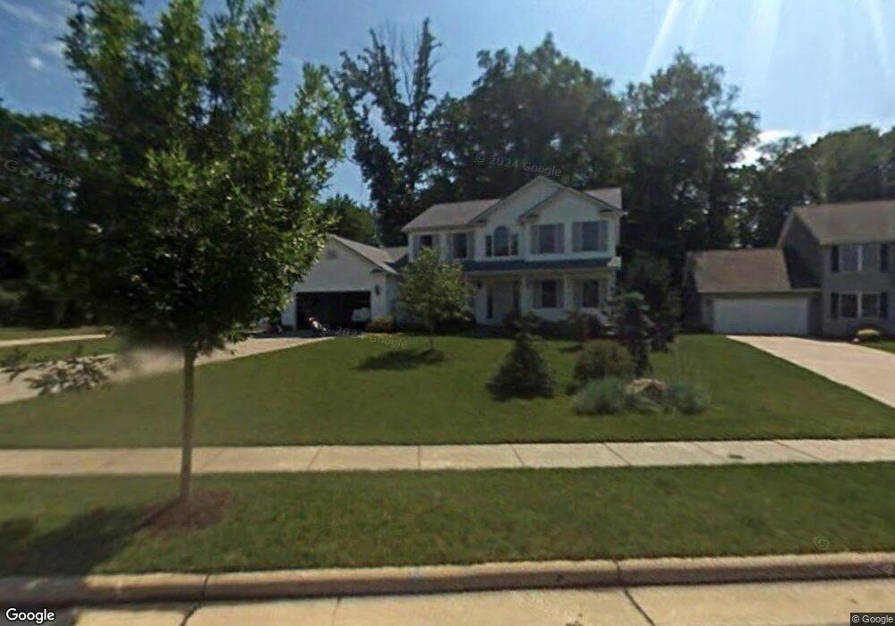
This home is located at 3273 Crown Pointe Dr, Stow, OH 44224 and is currently estimated at $446,155, approximately $175 per square foot. 3273 Crown Pointe Dr is a home located in Summit County with nearby schools including Stow-Munroe Falls High School and St Patrick Elementary School.
Ownership History
Date
Name
Owned For
Owner Type
Purchase Details
Closed on
Jun 14, 2006
Sold by
Brinko Robert J and Brinko Stacey L
Bought by
Li Quan and Jin Changshu
Current Estimated Value
Home Financials for this Owner
Home Financials are based on the most recent Mortgage that was taken out on this home.
Original Mortgage
$138,000
Interest Rate
6.68%
Mortgage Type
Fannie Mae Freddie Mac
Create a Home Valuation Report for This Property
The Home Valuation Report is an in-depth analysis detailing your home's value as well as a comparison with similar homes in the area
Home Values in the Area
Average Home Value in this Area
Purchase History
| Date | Buyer | Sale Price | Title Company |
|---|---|---|---|
| Li Quan | $274,666 | Miller Examining Service Inc |
Source: Public Records
Mortgage History
| Date | Status | Borrower | Loan Amount |
|---|---|---|---|
| Closed | Li Quan | $138,000 |
Source: Public Records
Tax History Compared to Growth
Tax History
| Year | Tax Paid | Tax Assessment Tax Assessment Total Assessment is a certain percentage of the fair market value that is determined by local assessors to be the total taxable value of land and additions on the property. | Land | Improvement |
|---|---|---|---|---|
| 2025 | $6,756 | $120,218 | $21,588 | $98,630 |
| 2024 | $6,756 | $120,218 | $21,588 | $98,630 |
| 2023 | $6,756 | $120,218 | $21,588 | $98,630 |
| 2022 | $6,601 | $103,772 | $18,610 | $85,162 |
| 2021 | $5,907 | $103,772 | $18,610 | $85,162 |
| 2020 | $5,805 | $103,770 | $18,610 | $85,160 |
| 2019 | $5,302 | $88,510 | $18,420 | $70,090 |
| 2018 | $5,215 | $88,510 | $18,420 | $70,090 |
| 2017 | $4,947 | $88,510 | $18,420 | $70,090 |
| 2016 | $5,093 | $81,570 | $18,420 | $63,150 |
| 2015 | $4,947 | $81,570 | $18,420 | $63,150 |
| 2014 | $4,952 | $81,570 | $18,420 | $63,150 |
| 2013 | $4,967 | $82,360 | $18,420 | $63,940 |
Source: Public Records
Map
Nearby Homes
- 978 Silver Meadows Blvd
- 600 Silver Meadows Blvd
- 1265 W Main St
- 4035 Villas Dr
- 2973 Mourning Dove Cir
- 2991 Heatherwood Ct Unit 30B
- 3127 Deercrest Path
- 3511 Whit Ave
- 3896 Lake Run Blvd
- 940 Kevin Dr
- 2908 Wexford Blvd
- 4451 Newcomer Rd
- 1181 Norwood St
- 566 Beech Dr
- 4233 Smokerise Dr
- 4227 Maribend Dr
- 505 Longmere Dr
- 3165 Peterboro Dr
- 3791 Baird Rd
- 3359 Churchill Downs
- 3281 Crown Pointe Dr
- 3265 Crown Pointe Dr
- 3289 Crown Pointe Dr
- 3257 Crown Pointe Dr
- 3297 Crown Pointe Dr
- 3243 Crown Pointe Dr
- 3270 Crown Pointe Dr
- 3305 Crown Pointe Dr
- 3302 Crown Pointe Dr
- 3313 Crown Pointe Dr
- 3254 Crown Pointe Dr
- 3310 Crown Pointe Dr
- 3246 Crown Pointe Dr
- 3217 Crown Pointe Dr
- 3318 Crown Pointe Dr
- 3209 Crown Pointe Dr
- 3326 Crown Pointe Dr
- 4627 Edgewater Dr
- 3230 Crown Pointe Dr
- 3334 Crown Pointe Dr