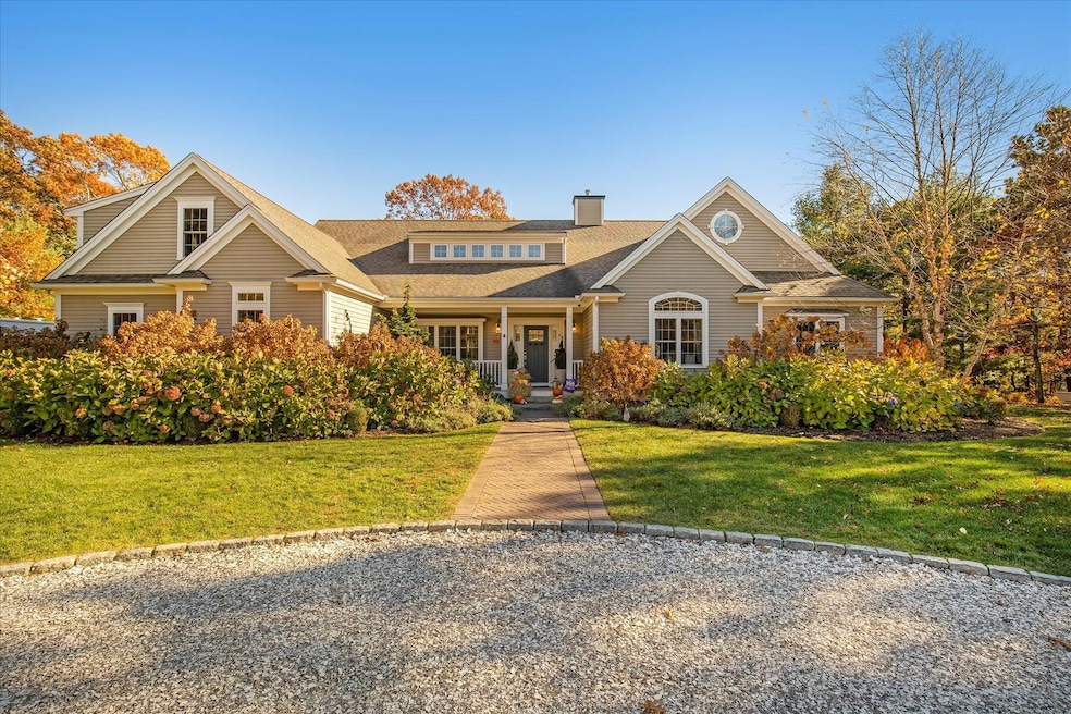
35 Spinnaker Dr W Mashpee, MA 2649
Mashpee Neck NeighborhoodEstimated payment $11,115/month
Highlights
- Property is near a marina
- 0.92 Acre Lot
- Cathedral Ceiling
- Mashpee High School Rated A-
- Contemporary Architecture
- Wood Flooring
About This Home
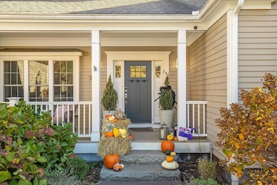
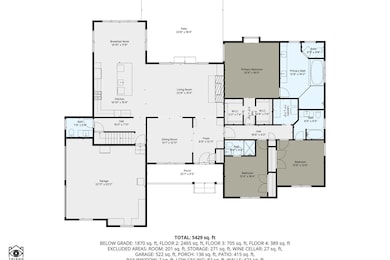
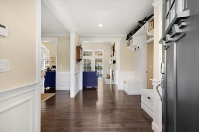
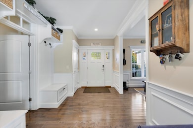
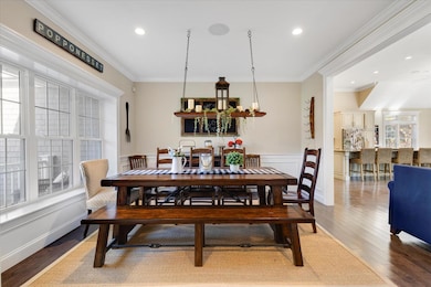
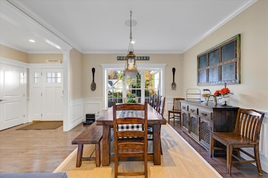
Experience luxury living at its finest in this stunning home built for entertaining. The open floor plan features a chef's kitchen flowing into a vaulted great room with a striking stone fireplace. All bedrooms are conveniently located on the first floor, including a primary suite with two walk-in closets and a spa-like bath. Each guest bedroom also offers a private ensuite. The second floor is an expansive flex space perfect for a game room, office, or studio. The lower level is an entertainer's dream--your own private movie theater with stepped seating, a full bath, and a custom bar with seating for 14, premium finishes, appliances, and a wine room. Enjoy quieter moments in the fireplace alcove or recharge in your private gym. Outdoors, relax among lush landscaping, an outdoor shower, and a built-in firepit. Complete with an attached two-car garage, and stand-by generator, this exceptional home offers quick access to Popponesset Bay and Mashpee Commons.
Home Details
Home Type
- Single Family
Est. Annual Taxes
- $10,172
Year Built
- Built in 2015
Lot Details
- 0.92 Acre Lot
- Property is zoned R3
Parking
- 2 Car Attached Garage
Home Design
- Contemporary Architecture
- Poured Concrete
- Asphalt Roof
- Shingle Siding
Interior Spaces
- 3,858 Sq Ft Home
- 2-Story Property
- Cathedral Ceiling
- Ceiling Fan
- 2 Fireplaces
- Finished Basement
- Interior Basement Entry
- Laundry on main level
Flooring
- Wood
- Carpet
Bedrooms and Bathrooms
- 3 Bedrooms
- Primary Bedroom on Main
- Cedar Closet
- Walk-In Closet
- Primary Bathroom is a Full Bathroom
Outdoor Features
- Outdoor Shower
- Property is near a marina
- Patio
Location
- Property is near golf course and shops
Utilities
- Central Air
- Heating Available
- Well
- Gas Water Heater
- Septic Tank
Community Details
- No Home Owners Association
- Parkside Subdivision
- Near Conservation Area
Listing and Financial Details
- Assessor Parcel Number MASH M:83 B:155 L:0
Map
Home Values in the Area
Average Home Value in this Area
Tax History
| Year | Tax Paid | Tax Assessment Tax Assessment Total Assessment is a certain percentage of the fair market value that is determined by local assessors to be the total taxable value of land and additions on the property. | Land | Improvement |
|---|---|---|---|---|
| 2025 | $10,172 | $1,536,600 | $285,400 | $1,251,200 |
| 2024 | $9,419 | $1,464,900 | $259,500 | $1,205,400 |
| 2023 | $8,645 | $1,233,300 | $247,100 | $986,200 |
| 2022 | $7,653 | $936,700 | $200,900 | $735,800 |
| 2021 | $7,463 | $822,800 | $181,000 | $641,800 |
| 2020 | $7,256 | $798,200 | $174,100 | $624,100 |
| 2019 | $6,869 | $759,000 | $174,100 | $584,900 |
| 2018 | $6,719 | $753,200 | $174,100 | $579,100 |
| 2017 | $6,842 | $744,500 | $174,100 | $570,400 |
| 2016 | $2,500 | $270,600 | $160,700 | $109,900 |
| 2015 | $1,586 | $174,100 | $174,100 | $0 |
| 2014 | $1,587 | $169,000 | $169,000 | $0 |
Property History
| Date | Event | Price | List to Sale | Price per Sq Ft |
|---|---|---|---|---|
| 11/07/2025 11/07/25 | For Sale | $1,995,000 | -- | $517 / Sq Ft |
Purchase History
| Date | Type | Sale Price | Title Company |
|---|---|---|---|
| Quit Claim Deed | -- | None Available | |
| Quit Claim Deed | -- | None Available |
Mortgage History
| Date | Status | Loan Amount | Loan Type |
|---|---|---|---|
| Open | $475,000 | New Conventional |
Source: Cape Cod & Islands Association of REALTORS®
MLS Number: 22505550
APN: MASH-000083-000155
Disclaimer: Certain information contained herein is derived from information provided by parties other than Homes.com. All information provided is deemed reliable, but is not guaranteed to be accurate and should be independently verified.
![]() All data relating to real estate for sale on this page comes from the Broker Reciprocity (BR) of the Cape Cod & Islands Multiple Listing Service, Inc. Detailed information about real estate listings held by brokerage firms other than CC&I Assoc. of REALTORS®, Inc. includes the name of the listing company. Neither the listing company nor CC&I Assoc. of REALTORS®, Inc. shall be responsible for any typographical errors, misinformation, misprints and shall be held totally harmless. The Broker providing this data believes it to be correct, but advises interested parties to confirm any item before relying on it in a purchase decision. All properties are subject to prior sale, changes, or withdrawal. Copyright 2026 © Cape Cod & Islands Multiple Listing Service, Inc. All rights reserved.
All data relating to real estate for sale on this page comes from the Broker Reciprocity (BR) of the Cape Cod & Islands Multiple Listing Service, Inc. Detailed information about real estate listings held by brokerage firms other than CC&I Assoc. of REALTORS®, Inc. includes the name of the listing company. Neither the listing company nor CC&I Assoc. of REALTORS®, Inc. shall be responsible for any typographical errors, misinformation, misprints and shall be held totally harmless. The Broker providing this data believes it to be correct, but advises interested parties to confirm any item before relying on it in a purchase decision. All properties are subject to prior sale, changes, or withdrawal. Copyright 2026 © Cape Cod & Islands Multiple Listing Service, Inc. All rights reserved.
- 11 Teal Cir
- 61 Shoestring Bay Rd
- 640 Poponessett Rd
- 640 Poponessett Rd
- 85 Clamshell Cove Rd
- 34 Rainbow Ln
- 25 Rainbow Ln
- 20 Mutiny Way
- 239 Clamshell Cove Rd
- 6 Willow Cir
- 311 Waquoit Rd
- 12 Tracey Rd
- 114 Orchard Rd
- 9 Red Cedar Rd Unit 9
- 9 Red Cedar Rd Unit 9
- 16 Gold Leaf Ln Unit 16
- 16 Gold Leaf Ln
- 52 Old Dock Ln
- 70 Simons Rd Unit E
- 70 Simons Rd
- 89 Sunset Cir Unit SI ID1386128P
- 38A Russell Rd
- 20 Brigantine Ave
- 8 Artisan Way
- 33 Green House Rd
- 185 Cotuit Rd Unit 1 Juniper
- 65 Starboard Ln
- 79 Ma-130
- 495 Sandwich Rd
- 101 Longfellow Dr
- 65 St Marks Rd
- 5 Anthonys Way
- 50 Hane Rd
- 8 Bridge St
- 21 Heritage Cir
- 308 Patriot Way Unit 308
- 282 Parker Rd
- 3 Worcester Ave
- 205 Nyes Neck Rd
- 1336 County Rd

Ask me questions while you tour the home.