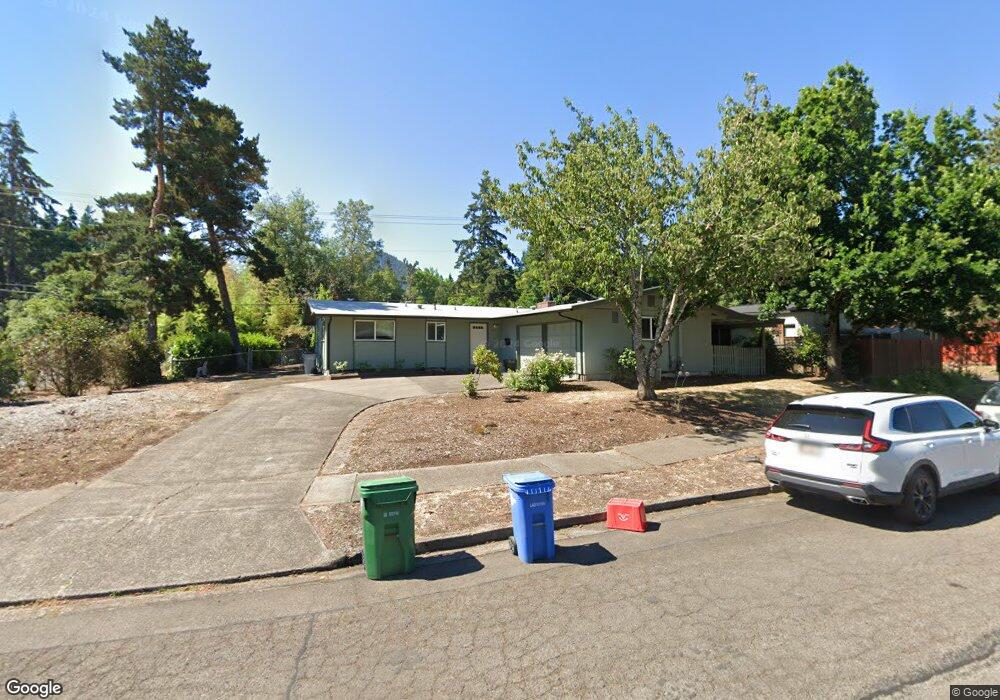
380 E 47th Ave Eugene, OR 97405
Southeast Eugene NeighborhoodEstimated Value: $414,000 - $490,000
3
Beds
2
Baths
1,056
Sq Ft
$428/Sq Ft
Est. Value
About This Home
This home is located at 380 E 47th Ave, Eugene, OR 97405 and is currently estimated at $451,684, approximately $427 per square foot. 380 E 47th Ave is a home located in Lane County with nearby schools including Edgewood Community Elementary School, Spencer Butte Middle School, and South Eugene High School.
Ownership History
Date
Name
Owned For
Owner Type
Purchase Details
Closed on
Jun 2, 2023
Sold by
Osness Jeanne
Bought by
Osness Living Trust and Osness
Current Estimated Value
Purchase Details
Closed on
Mar 16, 2023
Sold by
Golly Living Trust
Bought by
Osness Jeanne
Create a Home Valuation Report for This Property
The Home Valuation Report is an in-depth analysis detailing your home's value as well as a comparison with similar homes in the area
Home Values in the Area
Average Home Value in this Area
Purchase History
| Date | Buyer | Sale Price | Title Company |
|---|---|---|---|
| Osness Living Trust | -- | None Listed On Document | |
| Osness Jeanne | $325,000 | Cascade Title |
Source: Public Records
Tax History
| Year | Tax Paid | Tax Assessment Tax Assessment Total Assessment is a certain percentage of the fair market value that is determined by local assessors to be the total taxable value of land and additions on the property. | Land | Improvement |
|---|---|---|---|---|
| 2025 | $4,373 | $224,442 | -- | -- |
| 2024 | $4,319 | $217,905 | -- | -- |
| 2023 | $4,319 | $198,944 | $0 | $0 |
| 2022 | $3,805 | $193,150 | $0 | $0 |
| 2021 | $3,573 | $187,525 | $0 | $0 |
| 2020 | $3,586 | $182,064 | $0 | $0 |
| 2019 | $3,463 | $176,762 | $0 | $0 |
| 2018 | $3,260 | $166,616 | $0 | $0 |
| 2017 | $3,114 | $166,616 | $0 | $0 |
| 2016 | $3,037 | $161,763 | $0 | $0 |
| 2015 | $2,946 | $157,051 | $0 | $0 |
| 2014 | $2,872 | $152,477 | $0 | $0 |
Source: Public Records
Map
Nearby Homes
- 4734 Brookwood St
- 195 Coachman Dr
- 4315 High St
- 17 Westbrook Way
- 21 Westbrook Way
- 645 Kingswood Ave
- 278 Rockridge Ct
- 4695 Fox Hollow Rd
- 4083 Donald St Unit A
- 4495 Pinecrest Dr
- 4020 Pearl St
- 4023 Donald St Unit K
- 170 E 40th Ave
- 143 Treehill Loop Unit 143
- 152 Treehill Loop Unit 152
- 396 Brae Burn Dr
- 434 E 39th Ave
- 4103 Brae Burn Dr
- 422 Stonewood Dr Unit 422
- 4364 Fox Hollow Rd
- 320 E 47th Ave
- 385 E 48th Ave
- 365 E 48th Ave
- 351 E 47th Ave
- 280 E 47th Ave
- 315 E 47th Ave
- 410 Kingswood Ave
- 4690 Donald St
- 4797 Donald St
- 285 E 47th Ave
- 311 E 48th Ave
- 4695 Donald St
- 4805 Donald St
- 250 E 47th Ave
- 390 E 48th Ave
- 4801 Donald St
- 370 E 46th Ave
- 380 E 46th Ave
- 360 E 48th Ave
- 255 E 47th Ave