Estimated Value: $399,000 - $467,000
3
Beds
2
Baths
1,970
Sq Ft
$221/Sq Ft
Est. Value
About This Home
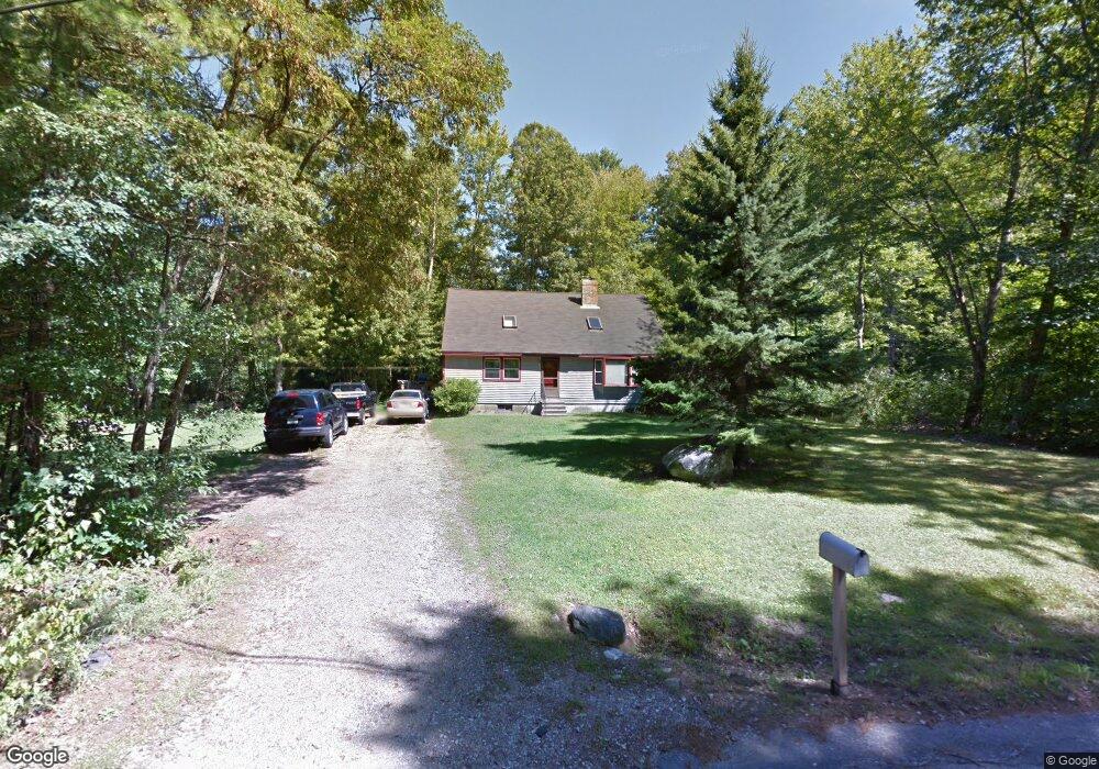
This home is located at 39 Colby Rd, Epsom, NH 03234 and is currently estimated at $435,293, approximately $220 per square foot. 39 Colby Rd is a home located in Merrimack County with nearby schools including Epsom Central School, Cornerstone Christian Academy, and Epsom Better Buddies.
Ownership History
Date
Name
Owned For
Owner Type
Purchase Details
Closed on
Jun 2, 2022
Sold by
Wing Seth M
Bought by
Wing Pamela and Pendleton Nicolas B
Current Estimated Value
Home Financials for this Owner
Home Financials are based on the most recent Mortgage that was taken out on this home.
Original Mortgage
$214,927
Outstanding Balance
$202,690
Interest Rate
5.1%
Mortgage Type
Purchase Money Mortgage
Estimated Equity
$232,603
Purchase Details
Closed on
Dec 16, 2003
Sold by
Peck Theron W and Peck Melanie A
Bought by
Wing Seth M
Home Financials for this Owner
Home Financials are based on the most recent Mortgage that was taken out on this home.
Original Mortgage
$172,000
Interest Rate
5.9%
Mortgage Type
Purchase Money Mortgage
Create a Home Valuation Report for This Property
The Home Valuation Report is an in-depth analysis detailing your home's value as well as a comparison with similar homes in the area
Home Values in the Area
Average Home Value in this Area
Purchase History
| Date | Buyer | Sale Price | Title Company |
|---|---|---|---|
| Wing Pamela | $300,000 | None Available | |
| Wing Seth M | $215,000 | -- |
Source: Public Records
Mortgage History
| Date | Status | Borrower | Loan Amount |
|---|---|---|---|
| Open | Wing Pamela | $214,927 | |
| Previous Owner | Wing Seth M | $194,442 | |
| Previous Owner | Wing Seth M | $172,000 |
Source: Public Records
Tax History
| Year | Tax Paid | Tax Assessment Tax Assessment Total Assessment is a certain percentage of the fair market value that is determined by local assessors to be the total taxable value of land and additions on the property. | Land | Improvement |
|---|---|---|---|---|
| 2025 | $7,758 | $442,300 | $172,400 | $269,900 |
| 2024 | $6,356 | $238,600 | $93,000 | $145,600 |
| 2023 | $6,130 | $248,900 | $93,000 | $155,900 |
| 2022 | $5,934 | $248,900 | $93,000 | $155,900 |
| 2021 | $5,884 | $248,900 | $93,000 | $155,900 |
| 2020 | $5,433 | $248,900 | $93,000 | $155,900 |
| 2019 | $5,805 | $214,300 | $84,600 | $129,700 |
| 2018 | $5,565 | $214,300 | $84,600 | $129,700 |
| 2017 | $5,501 | $214,300 | $84,600 | $129,700 |
| 2016 | $5,364 | $214,300 | $84,600 | $129,700 |
| 2015 | $5,086 | $213,500 | $84,600 | $128,900 |
| 2014 | $4,766 | $214,100 | $79,400 | $134,700 |
| 2013 | $4,798 | $212,600 | $79,400 | $133,200 |
Source: Public Records
Map
Nearby Homes
- 88 Old Town Road Extension
- 0 Dover Unit 33 & 35
- 5 Old Turnpike Rd
- 157 Old Turnpike Rd
- 80 Center Hill Rd
- 9 Princess Ln
- 2 Archer Cir
- 333 Dover Rd
- 11 Nash Ln
- 15 Nash Ln
- 19 Meadow Lark Ln
- 520 Goboro Rd
- 21 Depot Rd
- 1050 Dover Rd
- 0 Poor Town Rd Unit 4
- 27 Tyler Ave
- 35 Lake Rd
- 1563 1st New Hampshire Turnpike
- 67 Swiggey Brook Rd
- 94 Lakeshore Dr
- 44 Colby Rd
- Lot 4-36 Windsor
- 32 Colby Rd
- 50 Colby Rd
- 55 Colby Rd
- 17 Colby Rd
- 54 Colby Rd
- 59 Colby Rd
- 17 Leighton Brook Dr
- 20 Leighton Brook Dr
- 16 Pinnie Hill Rd
- 64 Colby Rd
- 28 Leighton Brook Dr
- 15 Pinnie Hill Rd
- 61 Colby Rd
- 85 Black Hall Rd
- 109 Black Hall Rd
- 87 Black Hall Rd
- 113 Black Hall Rd
- 25 Leighton Brook Dr
Your Personal Tour Guide
Ask me questions while you tour the home.