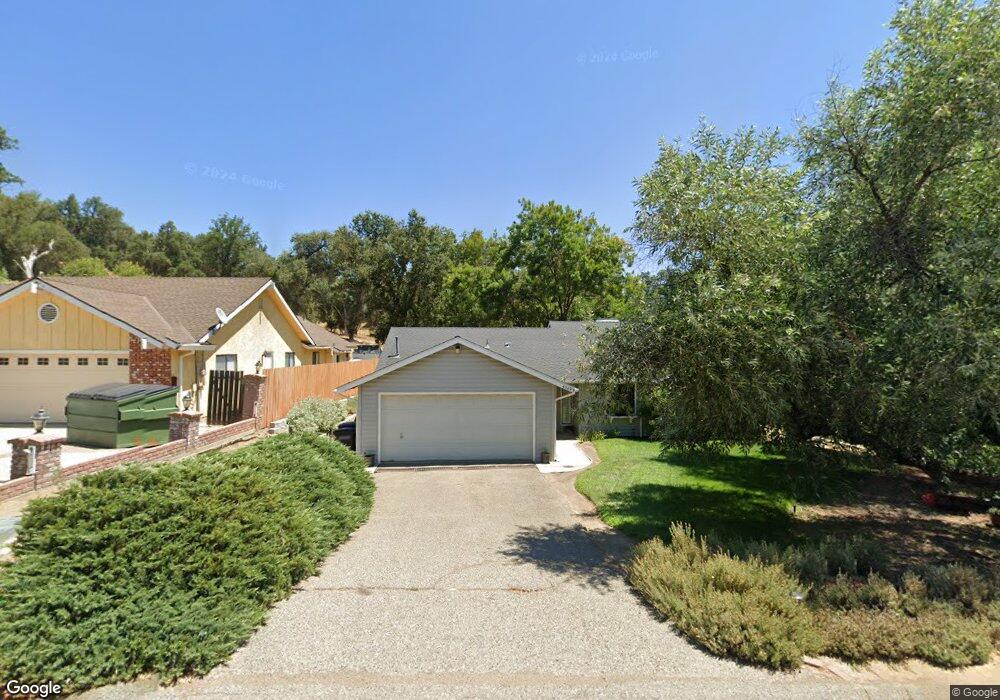
40499 Goldside Dr Oakhurst, CA 93644
Estimated Value: $329,623 - $388,000
3
Beds
2
Baths
1,450
Sq Ft
$240/Sq Ft
Est. Value
About This Home
This home is located at 40499 Goldside Dr, Oakhurst, CA 93644 and is currently estimated at $347,406, approximately $239 per square foot. 40499 Goldside Dr is a home located in Madera County with nearby schools including Wasuma Elementary School and Lex Christi Regit Academy.
Ownership History
Date
Name
Owned For
Owner Type
Purchase Details
Closed on
Mar 24, 2025
Sold by
Stanphill Sandra L and Morris Sandra L
Bought by
Morris Family Trust and Morris
Current Estimated Value
Purchase Details
Closed on
Oct 12, 1999
Sold by
Mitchell Patricia A
Bought by
Stanphill Sandra L
Home Financials for this Owner
Home Financials are based on the most recent Mortgage that was taken out on this home.
Original Mortgage
$87,300
Interest Rate
7.82%
Create a Home Valuation Report for This Property
The Home Valuation Report is an in-depth analysis detailing your home's value as well as a comparison with similar homes in the area
Home Values in the Area
Average Home Value in this Area
Purchase History
| Date | Buyer | Sale Price | Title Company |
|---|---|---|---|
| Morris Family Trust | -- | None Listed On Document | |
| Stanphill Sandra L | $97,000 | Chicago Title Co |
Source: Public Records
Mortgage History
| Date | Status | Borrower | Loan Amount |
|---|---|---|---|
| Previous Owner | Stanphill Sandra L | $87,300 |
Source: Public Records
Tax History Compared to Growth
Tax History
| Year | Tax Paid | Tax Assessment Tax Assessment Total Assessment is a certain percentage of the fair market value that is determined by local assessors to be the total taxable value of land and additions on the property. | Land | Improvement |
|---|---|---|---|---|
| 2025 | $1,460 | $149,060 | $38,413 | $110,647 |
| 2023 | $1,460 | $143,273 | $36,922 | $106,351 |
| 2022 | $1,414 | $140,465 | $36,199 | $104,266 |
| 2021 | $1,394 | $137,712 | $35,490 | $102,222 |
| 2020 | $1,386 | $136,301 | $35,127 | $101,174 |
| 2019 | $1,359 | $133,630 | $34,439 | $99,191 |
| 2018 | $1,326 | $131,011 | $33,764 | $97,247 |
| 2017 | $1,301 | $128,443 | $33,102 | $95,341 |
| 2016 | $1,258 | $125,925 | $32,453 | $93,472 |
| 2015 | $1,240 | $124,034 | $31,966 | $92,068 |
| 2014 | $1,219 | $121,605 | $31,340 | $90,265 |
Source: Public Records
Map
Nearby Homes
- 0 Goldside Dr
- 40570 Griffin Dr
- 46055 Sutton Dr
- 40879 Goldside Dr
- 41092 Highway 49
- 45344 S Oakview Dr
- 45412 N Oakview Dr
- 41243 Pamela Place
- 0 Deer Creek Dr
- 46281 Eastwood Dr S
- 0 Miami Place Unit FR25082118
- 0 Miami Place Unit 628644
- 46688 Eastwood Dr N
- 41409 Miami Way
- 45555 Lauri Ln
- 41028 Shandee Ln
- 40957 Shandee Ln
- 41345 Singing Hills Cir
- 41820 Dillon Cir
- 44611 Indian Rock Rd
- 40515 Goldside Dr
- 40485 Goldside Dr
- 46011 Ming Cir
- 40527 Goldside Dr
- 40498 Goldside Dr
- 40512 Goldside Dr
- 40539 Goldside Dr
- 40484 Goldside Dr
- 40524 Goldside Dr
- 46023 Ming Cir
- 45986 Ming Cir
- 40466 Goldside Dr
- 40553 Goldside Dr
- 40540 Goldside Dr
- 46014 Ming Cir
- 46026 Ming Cir
- 40552 Goldside Dr
- 40565 Goldside Dr
- 40484 Joan Dr
- 40468 Joan Dr