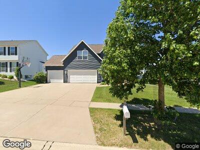
412 Westridge Dr SW Cedar Rapids, IA 52404
Cherry Hill Park NeighborhoodEstimated Value: $341,851 - $377,000
4
Beds
4
Baths
2,167
Sq Ft
$167/Sq Ft
Est. Value
About This Home
This home is located at 412 Westridge Dr SW, Cedar Rapids, IA 52404 and is currently estimated at $362,213, approximately $167 per square foot. 412 Westridge Dr SW is a home located in Linn County with nearby schools including West Willow Elementary School, Taft Middle School, and Thomas Jefferson High School.
Ownership History
Date
Name
Owned For
Owner Type
Purchase Details
Closed on
Mar 26, 2018
Sold by
Jonas James R and Jonas Yvonne L
Bought by
Lund Diane K
Current Estimated Value
Home Financials for this Owner
Home Financials are based on the most recent Mortgage that was taken out on this home.
Original Mortgage
$180,000
Outstanding Balance
$156,163
Interest Rate
3.87%
Mortgage Type
Adjustable Rate Mortgage/ARM
Estimated Equity
$224,237
Purchase Details
Closed on
Sep 3, 1999
Sold by
Midwest Development Co
Bought by
Jonas James R and Jonas Yvonne L
Home Financials for this Owner
Home Financials are based on the most recent Mortgage that was taken out on this home.
Original Mortgage
$174,998
Interest Rate
7.77%
Create a Home Valuation Report for This Property
The Home Valuation Report is an in-depth analysis detailing your home's value as well as a comparison with similar homes in the area
Home Values in the Area
Average Home Value in this Area
Purchase History
| Date | Buyer | Sale Price | Title Company |
|---|---|---|---|
| Lund Diane K | $233,000 | None Available | |
| Jonas James R | $218,500 | -- |
Source: Public Records
Mortgage History
| Date | Status | Borrower | Loan Amount |
|---|---|---|---|
| Open | Lund Diane K | $180,000 | |
| Previous Owner | Jonas James R | $250,000 | |
| Previous Owner | Jonas James R | $250,000 | |
| Previous Owner | Jonas James R | $25,000 | |
| Previous Owner | Jonas James R | $174,998 |
Source: Public Records
Tax History Compared to Growth
Tax History
| Year | Tax Paid | Tax Assessment Tax Assessment Total Assessment is a certain percentage of the fair market value that is determined by local assessors to be the total taxable value of land and additions on the property. | Land | Improvement |
|---|---|---|---|---|
| 2023 | $5,678 | $301,800 | $62,500 | $239,300 |
| 2022 | $4,994 | $278,100 | $54,900 | $223,200 |
| 2021 | $4,968 | $250,000 | $49,200 | $200,800 |
| 2020 | $4,968 | $233,800 | $49,200 | $184,600 |
| 2019 | $4,482 | $216,500 | $41,700 | $174,800 |
| 2018 | $4,354 | $216,500 | $41,700 | $174,800 |
| 2017 | $4,478 | $214,100 | $41,700 | $172,400 |
| 2016 | $4,357 | $205,000 | $41,700 | $163,300 |
| 2015 | $4,253 | $199,892 | $41,663 | $158,229 |
| 2014 | $4,068 | $210,648 | $41,663 | $168,985 |
| 2013 | $4,200 | $210,648 | $41,663 | $168,985 |
Source: Public Records
Map
Nearby Homes
- 321 Grey Slate Dr SW
- 6902 Underwood Ave SW
- 6919 Rockingham Dr SW
- 626 Grey Slate Dr SW
- 6922 Rock Wood Dr SW
- 6916 Rock Wood Dr SW
- 6907 Rock Wood Dr SW
- 6931 Rock Wood Dr SW
- 6664 Sand Ct SW
- 7500 16th Ave SW
- 1590 Stoney Pt Rd & 6600 16th Ave SW
- 6813 Terrazzo Dr NW
- 6350 Quail Ridge Dr SW Unit 6350
- 7806 Hillsboro Dr SW
- 0 Farm 2449 Tract 3373 Unit 2305839
- 6911 Springwood Place NW
- 103 Broadmore Rd SW
- 5817 Underwood Ave SW
- 207 Cherry Park Dr NW
- 218 Cherry Park Dr NW
- 412 Westridge Dr SW
- 418 Westridge Dr SW
- 406 Westridge Dr SW
- 413 Rockhurst Dr SW
- 400 Westridge Dr SW
- 419 Rockhurst Dr SW
- 424 Westridge Dr SW
- 407 Rockhurst Dr SW
- 409 Westridge Dr SW
- 415 Westridge Dr SW
- 425 Rockhurst Dr SW
- 403 Westridge Dr SW
- 401 Rockhurst Dr SW
- 328 Westridge Dr SW
- 427 Westridge Dr SW
- 327 Westridge Dr SW
- 329 Rockhurst Dr SW
- 502 Westridge Dr SW
- 322 Westridge Dr SW
- 408 Grey Slate Dr SW