
Seller's Agent in 2025
Wes Litton
Keller Williams
(417) 883-4900
347 Total Sales
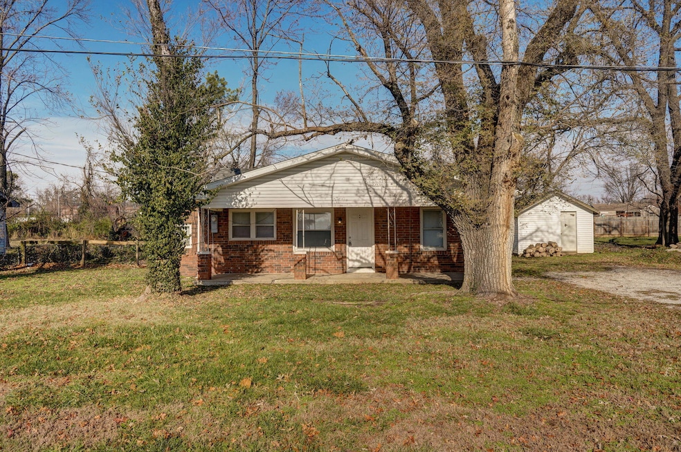
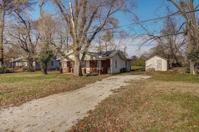

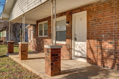
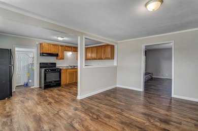
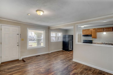

This inviting home sits in the well desired Willard School District and has tons to offer! Inside, the layout is cozy and functional — ideal for first-time buyers, a small family, or those seeking a simple, low-maintenance home with the added benefit of a large lot. With its modest footprint and yard space, the property holds potential for renovation or customization, giving buyers flexibility to update interiors or add outdoor amenities. It sits on almost half an acre giving you plenty of room for outdoor activities. Don't miss your chance, call to schedule a showing today!
Last Agent to Sell the Property
Keller Williams Brokerage Email: klrw369@kw.com License #2016010507 Listed on: 12/04/2025
| Date | Type | Sale Price | Title Company |
|---|---|---|---|
| Special Warranty Deed | -- | None Available | |
| Special Warranty Deed | -- | None Available | |
| Trustee Deed | $63,142 | None Available |
| Date | Status | Loan Amount | Loan Type |
|---|---|---|---|
| Open | $56,000 | Construction |
| Date | Event | Price | List to Sale | Price per Sq Ft |
|---|---|---|---|---|
| 12/22/2025 12/22/25 | Sold | -- | -- | -- |
| 12/07/2025 12/07/25 | Pending | -- | -- | -- |
| 12/04/2025 12/04/25 | For Sale | $80,000 | -- | $82 / Sq Ft |
| Year | Tax Paid | Tax Assessment Tax Assessment Total Assessment is a certain percentage of the fair market value that is determined by local assessors to be the total taxable value of land and additions on the property. | Land | Improvement |
|---|---|---|---|---|
| 2025 | $608 | $11,250 | $4,280 | $6,970 |
| 2024 | $560 | $10,170 | $2,850 | $7,320 |
| 2023 | $802 | $10,170 | $2,850 | $7,320 |
| 2022 | $549 | $9,960 | $2,850 | $7,110 |
| 2021 | $549 | $9,960 | $2,850 | $7,110 |
| 2020 | $554 | $9,960 | $2,850 | $7,110 |
| 2019 | $552 | $9,960 | $2,850 | $7,110 |
| 2018 | $1,320 | $10,110 | $2,850 | $7,260 |
| 2017 | $797 | $10,090 | $2,850 | $7,240 |
| 2016 | $554 | $10,090 | $2,850 | $7,240 |
| 2015 | $550 | $10,090 | $2,850 | $7,240 |
| 2014 | $555 | $10,110 | $2,850 | $7,260 |
Seller's Agent in 2025
Wes Litton
Keller Williams
(417) 883-4900
347 Total Sales
Buyer's Agent in 2025
Holt Homes Group
Keller Williams
(417) 409-2014
1,085 Total Sales
Source: Southern Missouri Regional MLS
MLS Number: 60311131
APN: 13-17-308-009
Disclaimer: Certain information contained herein is derived from information provided by parties other than Homes.com. All information provided is deemed reliable, but is not guaranteed to be accurate and should be independently verified.
![]() Based on information submitted to the MLS GRID. All data is obtained from various sources and may not have been verified by broker or MLS GRID. Supplied Open House Information is subject to change without notice. All information should be independently reviewed and verified for accuracy. Properties may or may not be listed by the office/agent presenting the information. Some IDX listings have been excluded from this website. The data relating to real estate for sale on this web page comes in part from the Internet Data Exchange (IDX) of the Southern Missouri Regional MLS, LLC, Inc. Real estate listings held by Brokerage firms other than Homes.com, LLC are marked with the IDX logo and detailed information about them includes the name of the listing Brokers. The information being provided is for consumers’ personal, noncommercial use and may not be used for any purpose other than to identify prospective properties consumers may be interested in purchasing. The information being provided is not guaranteed, and all information should be verified by the consumer. Any representation that a web site contains all listings shall only mean that the website contains all listings available to the public through the IDX data feed. There may be other properties offered through a REALTOR® that have not been displayed on this site. © 2026 Southern Missouri Regional MLS, LLC. All rights reserved.
Based on information submitted to the MLS GRID. All data is obtained from various sources and may not have been verified by broker or MLS GRID. Supplied Open House Information is subject to change without notice. All information should be independently reviewed and verified for accuracy. Properties may or may not be listed by the office/agent presenting the information. Some IDX listings have been excluded from this website. The data relating to real estate for sale on this web page comes in part from the Internet Data Exchange (IDX) of the Southern Missouri Regional MLS, LLC, Inc. Real estate listings held by Brokerage firms other than Homes.com, LLC are marked with the IDX logo and detailed information about them includes the name of the listing Brokers. The information being provided is for consumers’ personal, noncommercial use and may not be used for any purpose other than to identify prospective properties consumers may be interested in purchasing. The information being provided is not guaranteed, and all information should be verified by the consumer. Any representation that a web site contains all listings shall only mean that the website contains all listings available to the public through the IDX data feed. There may be other properties offered through a REALTOR® that have not been displayed on this site. © 2026 Southern Missouri Regional MLS, LLC. All rights reserved.
SOMO MLS respects the intellectual property rights of others and expects you to do the same. Per the DMCA, SOMO MLS will respond expeditiously to claims of copyright infringement on the Site if submitted to SOMO MLS' s Copyright Agent as described below. Upon receipt of a notice alleging copyright infringement, SOMO MLS will take whatever action it deems appropriate within its sole discretion, including removal of the allegedly infringing materials. If you believe that your intellectual property rights have been violated by SOMO MLS or by a third party who has uploaded materials to the Site, please provide the following information to SOMO MLS' s designated Copyright Agent listed below:
a. A description of the copyrighted work or other intellectual property that you claim has been infringed;
b. A description of where the material that you claim is infringing is located on the Site;
c. An address, telephone number, and e-mail address where SOMO MLS can contact you and, if different, an e-mail address where the alleged infringing party, if not SOMO MLS, can contact you;
d. A statement that you have a good-faith belief that the use is not authorized by the copyright owner or other intellectual property rights owner, by its agent, or by law;
e. A statement by you under penalty of perjury that the information in your notice is accurate and that you are the copyright or intellectual property owner or are authorized to act on the owner's behalf;
f. Your electronic or physical signature. SOMO MLS may request additional information before removing any allegedly infringing material.
In the event SOMO MLS removes the allegedly infringing materials, SOMO MLS will immediately notify the person responsible for posting such materials that SOMO MLS removed or disabled access to the materials. SOMO MLS may also provide the responsible person with your e-mail address so that the person may respond to your allegations. SOMO MLS reserves the right to terminate, limit or suspend any user's access to the Site in the event of repeated infringing activity. If you believe that a user of this Site is a repeat infringer, please follow the above instructions to contact SOMO MLS's Copyright Agent. Please include sufficient information to assist SOMO MLS in determining that the user repeatedly engaged in infringing activity. SOMO MLS registered a designated agent with the Copyright Office pursuant to 17 U.S.C. 512(c). SOMO MLS's designated Copyright Agent is: Jeff Kester 1310 Primrose, Springfield, MO 65804, Phone: 417-883-1226, Email: jeff@gsbor.com
Based on information submitted to the MLS GRID
Ask me questions while you tour the home.