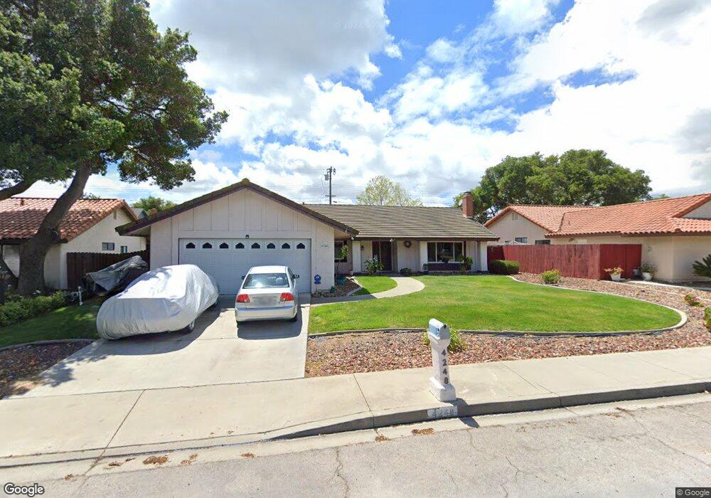
4248 Vanguard Dr Lompoc, CA 93436
Estimated Value: $678,852 - $737,000
4
Beds
2
Baths
1,776
Sq Ft
$403/Sq Ft
Est. Value
About This Home
This home is located at 4248 Vanguard Dr, Lompoc, CA 93436 and is currently estimated at $716,463, approximately $403 per square foot. 4248 Vanguard Dr is a home located in Santa Barbara County with nearby schools including Buena Vista Elementary School, Cabrillo High School, and Olive Grove Charter - Lompoc.
Ownership History
Date
Name
Owned For
Owner Type
Purchase Details
Closed on
Jul 11, 2002
Sold by
Smith Robin M
Bought by
Smith Geoffrey E
Current Estimated Value
Home Financials for this Owner
Home Financials are based on the most recent Mortgage that was taken out on this home.
Original Mortgage
$232,000
Interest Rate
6.69%
Create a Home Valuation Report for This Property
The Home Valuation Report is an in-depth analysis detailing your home's value as well as a comparison with similar homes in the area
Home Values in the Area
Average Home Value in this Area
Purchase History
| Date | Buyer | Sale Price | Title Company |
|---|---|---|---|
| Smith Geoffrey E | -- | Chicago Title Co |
Source: Public Records
Mortgage History
| Date | Status | Borrower | Loan Amount |
|---|---|---|---|
| Closed | Smith Geoffrey E | $232,000 |
Source: Public Records
Tax History
| Year | Tax Paid | Tax Assessment Tax Assessment Total Assessment is a certain percentage of the fair market value that is determined by local assessors to be the total taxable value of land and additions on the property. | Land | Improvement |
|---|---|---|---|---|
| 2025 | $4,732 | $404,759 | $183,980 | $220,779 |
| 2023 | $4,732 | $389,043 | $176,837 | $212,206 |
| 2022 | $4,659 | $381,416 | $173,370 | $208,046 |
| 2021 | $4,709 | $373,938 | $169,971 | $203,967 |
| 2020 | $4,662 | $370,105 | $168,229 | $201,876 |
| 2019 | $4,593 | $362,849 | $164,931 | $197,918 |
| 2018 | $4,528 | $355,736 | $161,698 | $194,038 |
| 2017 | $4,363 | $348,762 | $158,528 | $190,234 |
| 2016 | $4,018 | $341,924 | $155,420 | $186,504 |
| 2014 | $3,933 | $330,193 | $150,088 | $180,105 |
Source: Public Records
Map
Nearby Homes
- 113 Gemini Ave
- 232 Vega Ave
- 73 Stanford Cir
- 240 Oak Hill Dr
- 372 Oak Hill Dr
- 0 Oak Hill Dr Unit 24-783
- 3939 Mesa Circle Dr
- 649 Burning Tree Way
- 3916 Mesa Circle Dr Unit A
- 250 Saint Andrews Way
- 3725 Jupiter Ave
- 758 Voyager Rd
- 1445 Calle Marana
- 3660 Rucker Rd
- 972 Pellham Dr
- 832 Onstott Rd
- 1141 Pellham Dr
- 892 Onstott Rd
- 778 Tamarisk Dr
- 3578 Via Lato
- 4256 Vanguard Dr
- 4236 Vanguard Dr
- 4247 Arcturus Ave
- 4237 Arcturus Ave
- 4265 Arcturus Ave
- 4224 Vanguard Dr
- 4268 Vanguard Dr
- 4251 Vanguard Dr
- 4239 Vanguard Dr
- 4229 Arcturus Ave
- 4263 Vanguard Dr
- 4273 Arcturus Ave
- 4227 Vanguard Dr
- 4208 Vanguard Dr
- 4280 Vanguard Dr
- 4219 Arcturus Ave
- 4283 Arcturus Ave
- 108 Gemini St
Your Personal Tour Guide
Ask me questions while you tour the home.