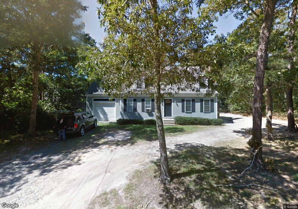
47 Popponesset Ave Mashpee, MA 02649
Estimated Value: $683,953 - $865,000
3
Beds
3
Baths
1,801
Sq Ft
$450/Sq Ft
Est. Value
About This Home
This home is located at 47 Popponesset Ave, Mashpee, MA 02649 and is currently estimated at $810,488, approximately $450 per square foot. 47 Popponesset Ave is a home located in Barnstable County with nearby schools including Kenneth C. Coombs School, Quashnet School, and Mashpee Middle School.
Ownership History
Date
Name
Owned For
Owner Type
Purchase Details
Closed on
Nov 9, 1998
Sold by
Mccarthy Michael J
Bought by
Willowbend Dev Corp
Current Estimated Value
Purchase Details
Closed on
Jun 3, 1998
Sold by
Peck David G
Bought by
Mccarthy Michael J
Home Financials for this Owner
Home Financials are based on the most recent Mortgage that was taken out on this home.
Original Mortgage
$115,000
Interest Rate
7.05%
Mortgage Type
Purchase Money Mortgage
Create a Home Valuation Report for This Property
The Home Valuation Report is an in-depth analysis detailing your home's value as well as a comparison with similar homes in the area
Home Values in the Area
Average Home Value in this Area
Purchase History
| Date | Buyer | Sale Price | Title Company |
|---|---|---|---|
| Willowbend Dev Corp | $169,900 | -- | |
| Mccarthy Michael J | $27,000 | -- |
Source: Public Records
Mortgage History
| Date | Status | Borrower | Loan Amount |
|---|---|---|---|
| Previous Owner | Mccarthy Michael J | $115,000 |
Source: Public Records
Tax History Compared to Growth
Tax History
| Year | Tax Paid | Tax Assessment Tax Assessment Total Assessment is a certain percentage of the fair market value that is determined by local assessors to be the total taxable value of land and additions on the property. | Land | Improvement |
|---|---|---|---|---|
| 2025 | $3,995 | $603,400 | $204,000 | $399,400 |
| 2024 | $3,641 | $566,300 | $185,500 | $380,800 |
| 2023 | $3,403 | $485,400 | $176,700 | $308,700 |
| 2022 | $3,266 | $399,700 | $143,600 | $256,100 |
| 2021 | $7,235 | $353,800 | $129,400 | $224,400 |
| 2020 | $3,120 | $343,200 | $124,400 | $218,800 |
| 2019 | $13,827 | $330,100 | $124,400 | $205,700 |
| 2018 | $6,646 | $318,000 | $124,400 | $193,600 |
| 2017 | $2,758 | $300,100 | $124,400 | $175,700 |
| 2016 | $2,678 | $289,800 | $124,400 | $165,400 |
| 2015 | $2,577 | $282,900 | $124,400 | $158,500 |
| 2014 | $2,639 | $281,000 | $122,900 | $158,100 |
Source: Public Records
Map
Nearby Homes
- 18 Pleasant Park Dr
- 11 Riverview Ave Unit H
- 107 Abbey Gate Rd
- 105 Bay Rd
- 45 Simons Rd Unit A
- 222 Willowbend Dr
- 44 The Heights
- 70 Simons Rd Unit E
- 70 Simons Rd
- 77 The Heights
- 266 School St
- 61 Shoestring Bay Rd
- 55 Shoestring Bay Rd
- 68 The Heights
- 31 N Glen Dr
- 37 Shoestring Bay Rd
- 6 Willow Cir
- 14 Willow Cir
- 39 Popponesset Ave
- 354 Quinaquisset Ave
- 44 Popponesset Ave
- 5 Angelo's Way
- 68 Florence Ave
- 5 Angelos Way
- 11 Angelos Way
- 12 Mount Vernon St
- 66 Florence Ave
- 25 Mount Vernon St
- 19 Angelos Way
- 10 Hawthorne St
- 32 Popponesset Ave
- 370 Quinaquisset Ave
- 27 Popponesset Ave
- 7 Mount Vernon St
- 43 Hazel St
- 363 Quinaquisset Ave
- 58 Florence Ave
- 28 Popponesset Ave