
Seller's Agent in 2025
Maryanne Alexander
Keller Williams Realty
(978) 996-8443
1 in this area
60 Total Sales
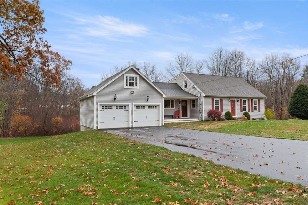
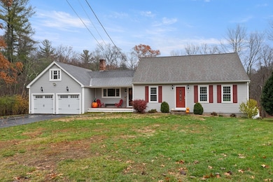
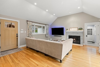
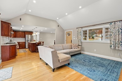
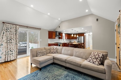
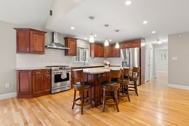
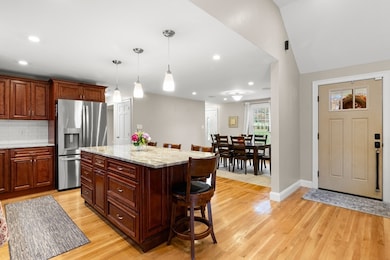
Offers due by Tuesday Nov 18th 5:00 PM Seller reserves the right to accept an offer sooner. Immaculate Renovated home on 2.25 Acres in Prime Andover Cul-de-Sac. Every major system updated- insulation, walls, ceilings, electricial, & plumbing. Expanded family room, with new mudroom & farmers porch. Recent hardwood floors in kitchen & family room. Open concept kitchen, dining & family room. Custom designed kitchen boasting an island that seats 4, plus stainless appliances. Formal living room. Luxurious bath with steam shower. High-efficiency heat pump, gas furnace with AC. On-demand hot water, and Energy Recovery Ventilator for year-round comfort. Bonus space above garage for storage or add a dormer, to make it ready to finish. Full walk out basement with expansion potential. Relax on the 20 x 12 AZEK deck overlooking private wooded grounds. Generator hookup. Town water & sewer. Fantastic location. Minutes from routes 93, 213 and 495. Shopping, restaurants, entertainment and tax free N
| Date | Type | Sale Price | Title Company |
|---|---|---|---|
| Quit Claim Deed | $990,000 | -- | |
| Quit Claim Deed | -- | -- | |
| Deed | $452,000 | -- | |
| Deed | -- | -- |
| Date | Status | Loan Amount | Loan Type |
|---|---|---|---|
| Open | $792,000 | New Conventional | |
| Previous Owner | $440,541 | Purchase Money Mortgage |
| Date | Event | Price | List to Sale | Price per Sq Ft |
|---|---|---|---|---|
| 12/11/2025 12/11/25 | Sold | $990,000 | +6.6% | $499 / Sq Ft |
| 11/18/2025 11/18/25 | Pending | -- | -- | -- |
| 11/11/2025 11/11/25 | For Sale | $929,000 | -- | $468 / Sq Ft |
| Year | Tax Paid | Tax Assessment Tax Assessment Total Assessment is a certain percentage of the fair market value that is determined by local assessors to be the total taxable value of land and additions on the property. | Land | Improvement |
|---|---|---|---|---|
| 2024 | $10,349 | $803,500 | $499,500 | $304,000 |
| 2023 | $9,910 | $725,500 | $449,900 | $275,600 |
| 2022 | $9,397 | $643,600 | $391,300 | $252,300 |
| 2021 | $8,997 | $588,400 | $355,700 | $232,700 |
| 2020 | $8,661 | $577,000 | $347,200 | $229,800 |
| 2019 | $8,417 | $551,200 | $336,900 | $214,300 |
| 2018 | $8,181 | $523,100 | $324,100 | $199,000 |
| 2017 | $7,840 | $516,500 | $317,600 | $198,900 |
| 2016 | $7,680 | $518,200 | $317,600 | $200,600 |
| 2015 | $7,424 | $495,900 | $305,200 | $190,700 |
Seller's Agent in 2025
Maryanne Alexander
Keller Williams Realty
(978) 996-8443
1 in this area
60 Total Sales
Buyer's Agent in 2025
John Beckshaw
Coldwell Banker Realty - Andovers/Readings Regional
(617) 771-3953
1 in this area
28 Total Sales
Source: MLS Property Information Network (MLS PIN)
MLS Number: 73453529
APN: ANDO-000204-000033
Disclaimer: Certain information contained herein is derived from information provided by parties other than Homes.com. All information provided is deemed reliable, but is not guaranteed to be accurate and should be independently verified.
![]() The property listing data and information, or the Images, set forth herein were provided to MLS Property Information Network, Inc. from third party sources, including sellers, lessors and public records, and were compiled by MLS Property Information Network, Inc. The property listing data and information, and the Images, are for the personal, non-commercial use of consumers having a good faith interest in purchasing or leasing listed properties of the type displayed to them and may not be used for any purpose other than to identify prospective properties which such consumers may have a good faith interest in purchasing or leasing. MLS Property Information Network, Inc. and its subscribers disclaim any and all representations and warranties as to the accuracy of the property listing data and information, or as to the accuracy of any of the Images, set forth herein.
The property listing data and information, or the Images, set forth herein were provided to MLS Property Information Network, Inc. from third party sources, including sellers, lessors and public records, and were compiled by MLS Property Information Network, Inc. The property listing data and information, and the Images, are for the personal, non-commercial use of consumers having a good faith interest in purchasing or leasing listed properties of the type displayed to them and may not be used for any purpose other than to identify prospective properties which such consumers may have a good faith interest in purchasing or leasing. MLS Property Information Network, Inc. and its subscribers disclaim any and all representations and warranties as to the accuracy of the property listing data and information, or as to the accuracy of any of the Images, set forth herein.
Ask me questions while you tour the home.