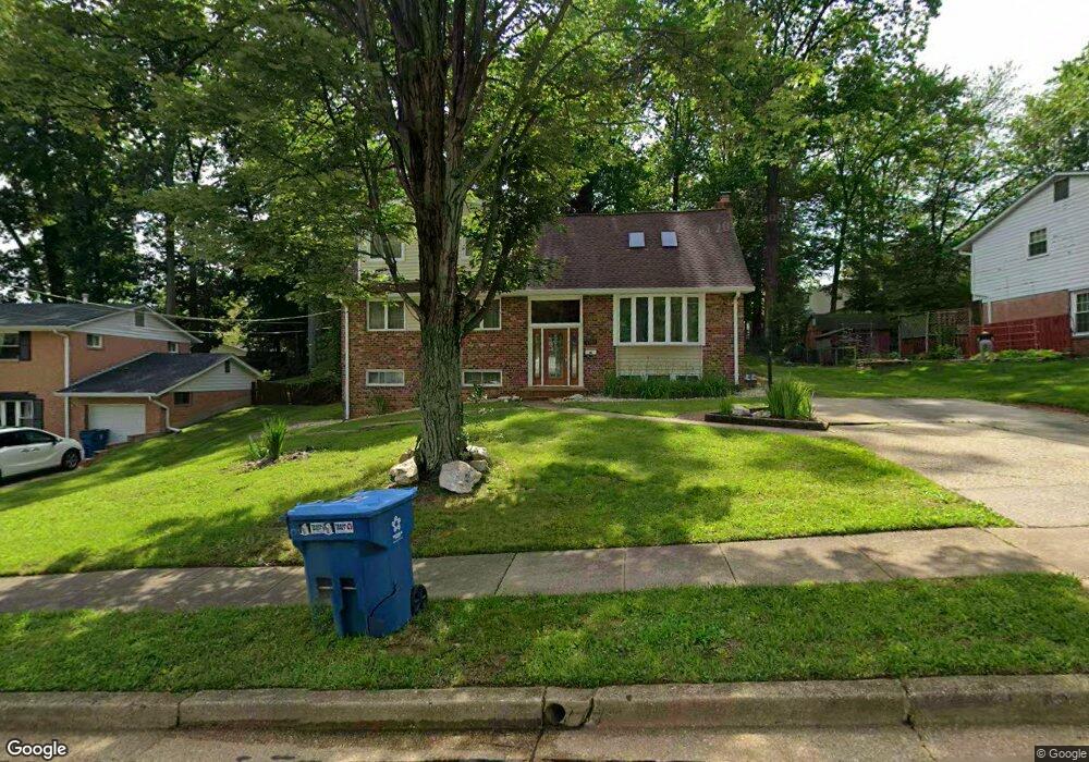
5502 Callander Dr Springfield, VA 22151
Estimated Value: $761,000 - $919,000
6
Beds
4
Baths
2,445
Sq Ft
$339/Sq Ft
Est. Value
About This Home
This home is located at 5502 Callander Dr, Springfield, VA 22151 and is currently estimated at $828,437, approximately $338 per square foot. 5502 Callander Dr is a home located in Fairfax County with nearby schools including Kings Park Elementary School, Kings Glen Elementary School, and Lake Braddock Secondary School.
Ownership History
Date
Name
Owned For
Owner Type
Purchase Details
Closed on
Dec 8, 1999
Sold by
Turner Albert S
Bought by
Matali Nziggire
Current Estimated Value
Home Financials for this Owner
Home Financials are based on the most recent Mortgage that was taken out on this home.
Original Mortgage
$191,872
Outstanding Balance
$60,246
Interest Rate
7.9%
Estimated Equity
$768,191
Create a Home Valuation Report for This Property
The Home Valuation Report is an in-depth analysis detailing your home's value as well as a comparison with similar homes in the area
Home Values in the Area
Average Home Value in this Area
Purchase History
| Date | Buyer | Sale Price | Title Company |
|---|---|---|---|
| Matali Nziggire | $208,500 | -- |
Source: Public Records
Mortgage History
| Date | Status | Borrower | Loan Amount |
|---|---|---|---|
| Open | Matali Nziggire | $191,872 |
Source: Public Records
Tax History
| Year | Tax Paid | Tax Assessment Tax Assessment Total Assessment is a certain percentage of the fair market value that is determined by local assessors to be the total taxable value of land and additions on the property. | Land | Improvement |
|---|---|---|---|---|
| 2025 | $8,626 | $817,160 | $310,000 | $507,160 |
| 2024 | $8,626 | $744,590 | $275,000 | $469,590 |
| 2023 | $8,314 | $736,700 | $275,000 | $461,700 |
| 2022 | $8,311 | $726,830 | $270,000 | $456,830 |
| 2021 | $7,228 | $615,950 | $240,000 | $375,950 |
| 2020 | $6,979 | $589,670 | $235,000 | $354,670 |
| 2019 | $6,723 | $568,030 | $227,000 | $341,030 |
| 2018 | $6,314 | $549,030 | $208,000 | $341,030 |
| 2017 | $6,212 | $535,030 | $194,000 | $341,030 |
| 2016 | $6,198 | $535,030 | $194,000 | $341,030 |
Source: Public Records
Map
Nearby Homes
- 5519 Yorkshire St
- 5004 Prince Caspian Ln
- 8802 Parliament Dr
- 5613 Eastbourne Dr
- 5401 Southampton Dr
- 9010 Lake Braddock Dr
- 8806 Cromwell Dr
- 8816 Victoria Rd
- 5624 Kirkham Ct
- 5812 Royal Ridge Dr Unit C
- 9101 Blue Jug Landing
- 8434 Thames St
- 5835 Fitzhugh St
- 5802 Torington Dr Unit 825
- 5772 Rexford Ct
- 5824 Rexford Dr Unit 731
- 8318 Uxbridge Ct
- 5845 Rexford Dr Unit 721
- 8523 Lakinhurst Ln
- 5844 Kara Place
- 5504 Callander Dr
- 5500 Callander Dr
- 8715 Kenilworth Dr
- 5503 Ventnor Ln
- 5505 Ventnor Ln
- 5506 Callander Dr
- 5503 Callander Dr
- 5507 Ventnor Ln
- 8709 Kenilworth Dr
- 5505 Callander Dr
- 8717 Kenilworth Dr
- 5509 Ventnor Ln
- 5508 Callander Dr
- 8712 Kenilworth Dr
- 8714 Kenilworth Dr
- 8710 Kenilworth Dr
- 5502 Yorkshire St
- 5507 Callander Dr
- 5500 Yorkshire St
- 5511 Ventnor Ln
Your Personal Tour Guide
Ask me questions while you tour the home.