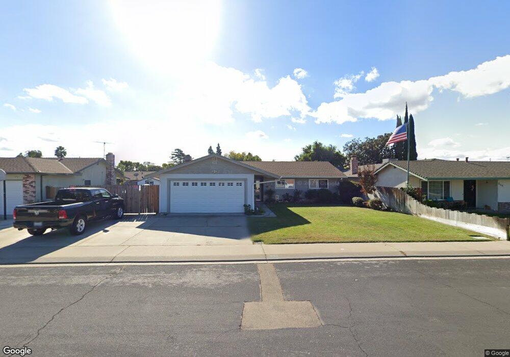
632 Birchwood St Manteca, CA 95336
Downtown Manteca NeighborhoodEstimated Value: $360,000 - $473,468
3
Beds
2
Baths
1,351
Sq Ft
$327/Sq Ft
Est. Value
About This Home
This home is located at 632 Birchwood St, Manteca, CA 95336 and is currently estimated at $442,367, approximately $327 per square foot. 632 Birchwood St is a home located in San Joaquin County with nearby schools including Neil Hafley Elementary School, East Union High School, and St. Anthony's Catholic School.
Ownership History
Date
Name
Owned For
Owner Type
Purchase Details
Closed on
Jan 8, 2004
Sold by
Neves Jason W and Neves Brenda A
Bought by
Neves Leonard D and Neves Jaclyn K
Current Estimated Value
Purchase Details
Closed on
Sep 15, 1998
Sold by
Neves Jason W and Neves Leonard
Bought by
Neves Leonard D and Neves Jaclyn K
Home Financials for this Owner
Home Financials are based on the most recent Mortgage that was taken out on this home.
Original Mortgage
$80,000
Interest Rate
6.88%
Create a Home Valuation Report for This Property
The Home Valuation Report is an in-depth analysis detailing your home's value as well as a comparison with similar homes in the area
Home Values in the Area
Average Home Value in this Area
Purchase History
| Date | Buyer | Sale Price | Title Company |
|---|---|---|---|
| Neves Leonard D | -- | -- | |
| Neves Leonard D | -- | Old Republic Title Company |
Source: Public Records
Mortgage History
| Date | Status | Borrower | Loan Amount |
|---|---|---|---|
| Closed | Neves Leonard D | $80,000 |
Source: Public Records
Tax History Compared to Growth
Tax History
| Year | Tax Paid | Tax Assessment Tax Assessment Total Assessment is a certain percentage of the fair market value that is determined by local assessors to be the total taxable value of land and additions on the property. | Land | Improvement |
|---|---|---|---|---|
| 2025 | $2,944 | $263,594 | $92,349 | $171,245 |
| 2024 | $2,861 | $258,427 | $90,539 | $167,888 |
| 2023 | $2,827 | $253,361 | $88,764 | $164,597 |
| 2022 | $2,784 | $248,394 | $87,024 | $161,370 |
| 2021 | $2,754 | $243,524 | $85,318 | $158,206 |
| 2020 | $2,643 | $241,028 | $84,444 | $156,584 |
| 2019 | $2,609 | $236,303 | $82,789 | $153,514 |
| 2018 | $2,574 | $231,670 | $81,166 | $150,504 |
| 2017 | $2,537 | $227,128 | $79,575 | $147,553 |
| 2016 | $2,476 | $222,677 | $78,016 | $144,661 |
| 2014 | $2,238 | $209,000 | $73,000 | $136,000 |
Source: Public Records
Map
Nearby Homes
- 1870 Pecanwood Ave
- 447 Ericwood Ct
- 1660 Kingwood Ave
- 1624 S Highway 99 Unit 19
- 439 Ericwood Ct
- 2016 Westboro Ln
- 2021 Holbrook Place
- 1807 Crestwood Ave
- 1755 Crestwood Ave
- 1340 Crimson Place
- 1485 Eastwood Ave
- 1480 Eastwood Ave
- 6288 E Lathrop Rd
- 434 Joseph Rd
- 607 Diane Dr
- 1624 S Frontage Rd Unit 21
- 1460 Primitivo Ln
- 11097 S Union Rd
- 1342 Santini Ave
- 2254 Maple Hollow Ln
- 624 Birchwood St
- 644 Birchwood St
- 627 Parkwood Dr
- 635 Parkwood Dr
- 619 Parkwood Dr
- 616 Birchwood St
- 650 Birchwood St
- 645 Parkwood Dr
- 609 Parkwood Dr
- 1859 Redwood Ave
- 1842 Cherrywood Place
- 658 Birchwood St
- 1829 Fairwood Ave
- 653 Parkwood Dr
- 1801 Fairwood Ave
- 655 Birchwood St
- 1776 Silverwood Ave
- 620 Parkwood Dr
- 1875 Redwood Ave
- 1820 Olivewood Ave