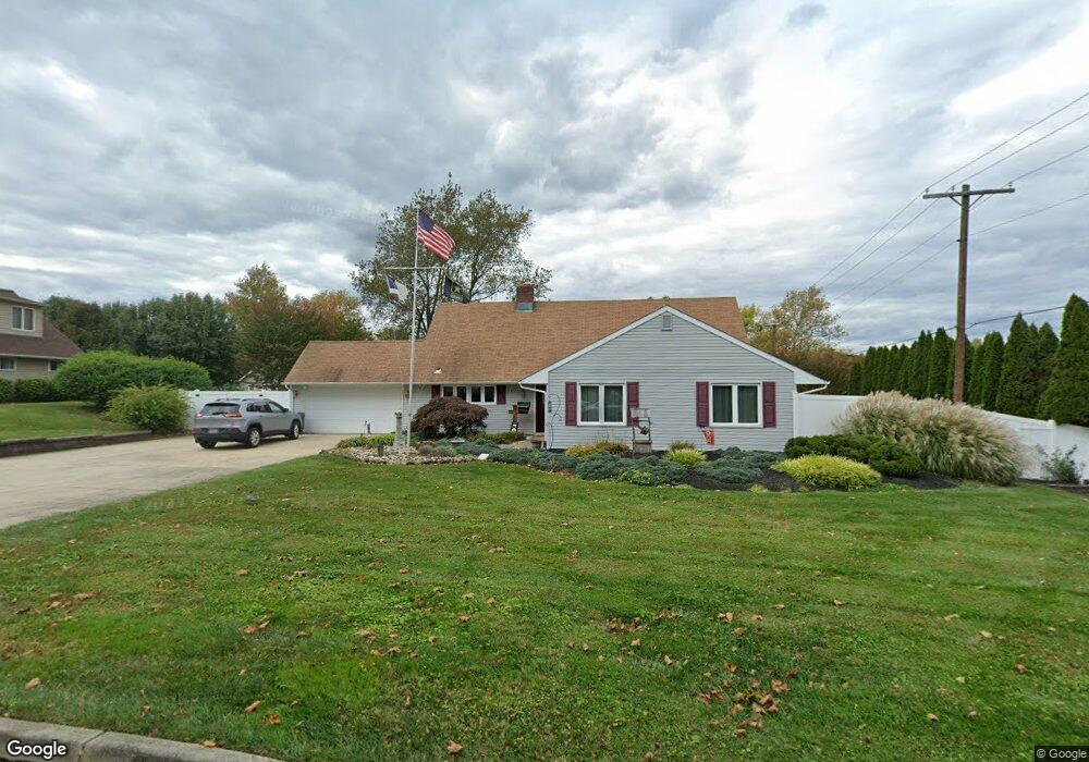
69 Seckelpear Rd Levittown, PA 19056
Snowball Gate NeighborhoodEstimated Value: $507,773 - $532,000
4
Beds
3
Baths
2,298
Sq Ft
$226/Sq Ft
Est. Value
About This Home
This home is located at 69 Seckelpear Rd, Levittown, PA 19056 and is currently estimated at $518,443, approximately $225 per square foot. 69 Seckelpear Rd is a home located in Bucks County with nearby schools including Albert Schweitzer Elementary School, Sandburg Middle School, and Neshaminy High School.
Ownership History
Date
Name
Owned For
Owner Type
Purchase Details
Closed on
Feb 12, 2007
Sold by
Cook George and Cook Terri R
Bought by
Cook George and Cook Terri R
Current Estimated Value
Home Financials for this Owner
Home Financials are based on the most recent Mortgage that was taken out on this home.
Original Mortgage
$244,000
Outstanding Balance
$146,713
Interest Rate
6.23%
Mortgage Type
New Conventional
Estimated Equity
$371,730
Purchase Details
Closed on
Jun 16, 2006
Sold by
Winiesky Michael and Winiesky Linda
Bought by
Roberts Terri L and Cook George
Home Financials for this Owner
Home Financials are based on the most recent Mortgage that was taken out on this home.
Original Mortgage
$244,000
Interest Rate
6.6%
Mortgage Type
Purchase Money Mortgage
Purchase Details
Closed on
Sep 9, 1999
Sold by
Vandermeer Wilhelmina D
Bought by
Winiesky Michael and Winiesky Linda
Home Financials for this Owner
Home Financials are based on the most recent Mortgage that was taken out on this home.
Original Mortgage
$112,000
Interest Rate
7.81%
Create a Home Valuation Report for This Property
The Home Valuation Report is an in-depth analysis detailing your home's value as well as a comparison with similar homes in the area
Home Values in the Area
Average Home Value in this Area
Purchase History
| Date | Buyer | Sale Price | Title Company |
|---|---|---|---|
| Cook George | -- | None Available | |
| Roberts Terri L | $305,000 | Lawyers Title Insurance Corp | |
| Winiesky Michael | $152,000 | -- |
Source: Public Records
Mortgage History
| Date | Status | Borrower | Loan Amount |
|---|---|---|---|
| Open | Cook George | $244,000 | |
| Closed | Roberts Terri L | $244,000 | |
| Previous Owner | Winiesky Michael | $112,000 |
Source: Public Records
Tax History Compared to Growth
Tax History
| Year | Tax Paid | Tax Assessment Tax Assessment Total Assessment is a certain percentage of the fair market value that is determined by local assessors to be the total taxable value of land and additions on the property. | Land | Improvement |
|---|---|---|---|---|
| 2025 | $5,834 | $26,800 | $6,600 | $20,200 |
| 2024 | $5,834 | $26,800 | $6,600 | $20,200 |
| 2023 | $5,742 | $26,800 | $6,600 | $20,200 |
| 2022 | $5,591 | $26,800 | $6,600 | $20,200 |
| 2021 | $5,591 | $26,800 | $6,600 | $20,200 |
| 2020 | $5,524 | $26,800 | $6,600 | $20,200 |
| 2019 | $5,401 | $26,800 | $6,600 | $20,200 |
| 2018 | $5,302 | $26,800 | $6,600 | $20,200 |
| 2017 | $5,166 | $26,800 | $6,600 | $20,200 |
| 2016 | $5,166 | $26,800 | $6,600 | $20,200 |
| 2015 | $5,562 | $26,800 | $6,600 | $20,200 |
| 2014 | $5,562 | $26,800 | $6,600 | $20,200 |
Source: Public Records
Map
Nearby Homes
- 75 Seckelpear Rd
- 63 Seckelpear Rd
- 92 Silverspruce Rd
- 247 Snowball Dr
- 84 Silverspruce Rd
- 68 Seckelpear Rd
- 74 Seckelpear Rd
- 60 Seckelpear Rd
- 59 Seckelpear Rd
- 80 Silverspruce Rd
- 80 Seckelpear Rd
- 39 Shellflower Rd
- 91 Silverspruce Rd
- 45 Shellflower Rd
- 72 Silverspruce Rd
- 54 Seckelpear Rd
- 55 Seckelpear Rd
- 35 Shellflower Rd
- 85 Silverspruce Rd
- 263 Snowball Dr