
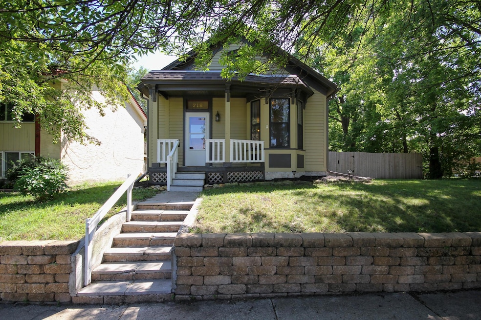
718 Watson Ave Saint Paul, MN 55102
West Seventh NeighborhoodEstimated payment $1,854/month
Total Views
1,770
3
Beds
1
Bath
1,030
Sq Ft
$262
Price per Sq Ft
Highlights
- Popular Property
- No HOA
- Eat-In Kitchen
- Highland Park Senior High Rated A
- The kitchen features windows
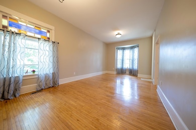
- Living Room
About This Home
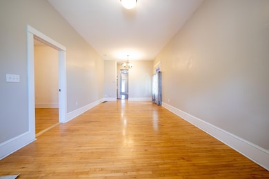
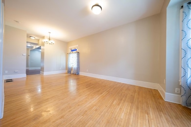
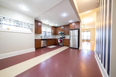
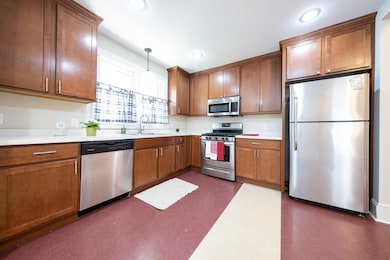
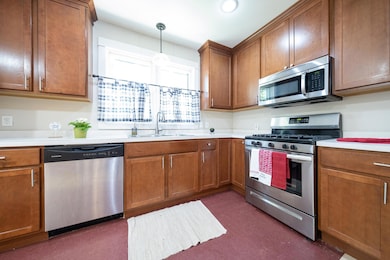
Charming St. Paul rambler with large privacy fence in the backyard! This SFH is in a very nice neighborhood near lots of shops and restaurants. There are three bedrooms and one bathroom. This home has hardwood floors and tall ceilings. Very spacious living area with a beautiful front-facing bay window. The kitchen is large with plenty of cabinetry and stainless steel appliances, including a gas stove. ALL 3 bedrooms are on the main floor as well as the bathroom AND washer and dryer! Walk out to the backyard on the spacious deck and into the green grass with a sweet 6 ft privacy fence all the way around! This property includes a 2-car garage facing alley, a front porch, central A/C, and room for storage in the unfinished basement.
Home Details
Home Type
- Single Family
Est. Annual Taxes
- $4,338
Year Built
- Built in 1885
Lot Details
- 7,100 Sq Ft Lot
- Lot Dimensions are 57x125
- Property is Fully Fenced
- Wood Fence
Parking
- 2 Car Garage
- Garage Door Opener
Interior Spaces
- 1,030 Sq Ft Home
- 1-Story Property
- Living Room
- Unfinished Basement
- Basement Fills Entire Space Under The House
- Dryer
Kitchen
- Eat-In Kitchen
- Range
- Microwave
- Dishwasher
- The kitchen features windows
Bedrooms and Bathrooms
- 3 Bedrooms
- 1 Full Bathroom
Utilities
- Forced Air Heating and Cooling System
Community Details
- No Home Owners Association
- Finchs Add Subdivision
Listing and Financial Details
- Assessor Parcel Number 112823410156
Map
Create a Home Valuation Report for This Property
The Home Valuation Report is an in-depth analysis detailing your home's value as well as a comparison with similar homes in the area
Home Values in the Area
Average Home Value in this Area
Tax History
| Year | Tax Paid | Tax Assessment Tax Assessment Total Assessment is a certain percentage of the fair market value that is determined by local assessors to be the total taxable value of land and additions on the property. | Land | Improvement |
|---|---|---|---|---|
| 2023 | $4,664 | $267,600 | $40,000 | $227,600 |
| 2022 | $3,704 | $245,100 | $40,000 | $205,100 |
| 2021 | $258 | $215,500 | $40,000 | $175,500 |
| 2020 | $257 | $207,100 | $24,300 | $182,800 |
| 2019 | $3,492 | $206,900 | $24,300 | $182,600 |
| 2018 | $3,208 | $193,000 | $24,300 | $168,700 |
| 2017 | $3,068 | $183,300 | $24,300 | $159,000 |
| 2016 | $2,788 | $0 | $0 | $0 |
| 2015 | $1,652 | $144,300 | $24,300 | $120,000 |
| 2014 | $1,160 | $0 | $0 | $0 |
Source: Public Records
Property History
| Date | Event | Price | Change | Sq Ft Price |
|---|---|---|---|---|
| 07/10/2025 07/10/25 | For Sale | $270,000 | -- | $262 / Sq Ft |
Source: NorthstarMLS
Purchase History
| Date | Type | Sale Price | Title Company |
|---|---|---|---|
| Warranty Deed | $205,000 | Watermark Title | |
| Warranty Deed | $154,545 | None Available | |
| Warranty Deed | -- | None Available |
Source: Public Records
Mortgage History
| Date | Status | Loan Amount | Loan Type |
|---|---|---|---|
| Open | $205,000 | VA | |
| Previous Owner | $26,000 | Credit Line Revolving | |
| Previous Owner | $100,000 | Unknown |
Source: Public Records
Similar Homes in Saint Paul, MN
Source: NorthstarMLS
MLS Number: 6750595
APN: 11-28-23-41-0156
Disclaimer: Certain information contained herein is derived from information provided by parties other than Homes.com. All information provided is deemed reliable, but is not guaranteed to be accurate and should be independently verified.
![]() Based on information submitted to the MLS GRID. All data is obtained from various sources and may not have been verified by broker or MLS GRID. Supplied Open House Information is subject to change without notice. All information should be independently reviewed and verified for accuracy. Properties may or may not be listed by the office/agent presenting the information. Some IDX listings have been excluded from this website.
Based on information submitted to the MLS GRID. All data is obtained from various sources and may not have been verified by broker or MLS GRID. Supplied Open House Information is subject to change without notice. All information should be independently reviewed and verified for accuracy. Properties may or may not be listed by the office/agent presenting the information. Some IDX listings have been excluded from this website.
The Digital Millennium Copyright Act of 1998, 17 U.S.C. § 512 (the “DMCA”) provides recourse for copyright owners who believe that material appearing on the Internet infringes their rights under U.S. copyright law. If you believe in good faith that any content or material made available in connection with our website or services infringes your copyright, you (or your agent) may send us a notice requesting that the content or material be removed, or access to it blocked.
Notices must be sent in writing by email to DMCAnotice@MLSGrid.com.
The DMCA requires that your notice of alleged copyright infringement include the following information:
(1) description of the copyrighted work that is the subject of claimed infringement;
(2) description of the alleged infringing content and information sufficient to permit us to locate the content;
(3) contact information for you, including your address, telephone number and email address;
(4) a statement by you that you have a good faith belief that the content in the manner complained of is not authorized by the copyright owner, or its agent, or by the operation of any law;
(5) a statement by you, signed under penalty of perjury, that the information in the notification is accurate and that you have the authority to enforce the copyrights that are claimed to be infringed; and
(6) a physical or electronic signature of the copyright owner or a person authorized to act on the copyright owner’s behalf. Failure to include all of the above information may result in the delay of the processing of your complaint.
Nearby Homes
- 587 Bay St
- 697 Tuscarora Ave
- 716 Stewart Ave
- 732 Randolph Ave
- 1271 - 1273 7th St W
- 1291 7th St W
- 851 Watson Ave
- 1297 7th St W
- 690 Mercer St
- 402 Clifton St
- 956 Juno Ave
- 927 James Ave
- 955 Otto Ave
- 407 Colborne St Unit 407
- 1032 Scheffer Ave
- 270 7th St W
- 1579 W Race St
- 226 Grotto St S
- 760 Linwood Ave
- 576 Lexington Pkwy S
- 613 Bay St Unit 1 Downstairs
- 1055 7th St W Unit 2
- 1055 7th St W Unit 2 Bed 1 Bath large Deck
- 1049 7th St W Unit 2
- 853 Randolph Ave Unit 3
- 408 Fulton St
- 731 Victoria St S
- 740 Victoria St S
- 375 Erie St Unit 1
- 260 Osceola Ave S
- 1529 Adrian St
- 380 Randolph Ave
- 749 Linwood Ave
- 894 St Clair Ave
- 470 Lexington Pkwy S
- 535 S Lexington Pkwy S
- 1136 Randolph Ave
- 360 Lexington Pkwy S
- 1017 Linwood Ave
- 425 W Superior St