Estimated Value: $280,000 - $282,095
4
Beds
3
Baths
2,352
Sq Ft
$119/Sq Ft
Est. Value
About This Home
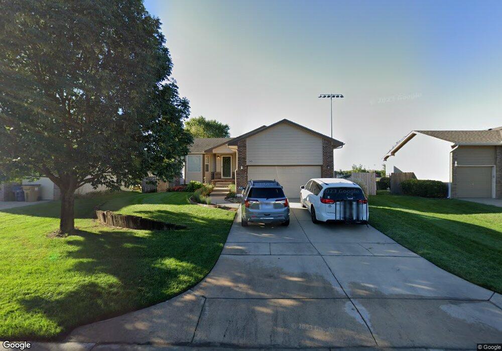
This home is located at 743 Laramie Cir, Maize, KS 67101 and is currently estimated at $281,048, approximately $119 per square foot. 743 Laramie Cir is a home located in Sedgwick County with nearby schools including Vermillion Elementary School, Pray-Woodman Elementary, and Maize Elementary School.
Ownership History
Date
Name
Owned For
Owner Type
Purchase Details
Closed on
Sep 3, 2010
Sold by
Lockhart Jeffrey B and Lockhart Angelina E
Bought by
Princ Mark J and Princ Cynthia S
Current Estimated Value
Home Financials for this Owner
Home Financials are based on the most recent Mortgage that was taken out on this home.
Original Mortgage
$140,013
Outstanding Balance
$91,559
Interest Rate
4.25%
Mortgage Type
FHA
Estimated Equity
$189,489
Purchase Details
Closed on
Jan 4, 2010
Sold by
Lockhart Jeffrey B and Lockhurt Angelian E
Bought by
Lockhart Jeffrey B and Lockhart Angelina E
Home Financials for this Owner
Home Financials are based on the most recent Mortgage that was taken out on this home.
Original Mortgage
$22,360
Interest Rate
4.8%
Mortgage Type
New Conventional
Create a Home Valuation Report for This Property
The Home Valuation Report is an in-depth analysis detailing your home's value as well as a comparison with similar homes in the area
Home Values in the Area
Average Home Value in this Area
Purchase History
| Date | Buyer | Sale Price | Title Company |
|---|---|---|---|
| Princ Mark J | -- | Security 1St Title | |
| Lockhart Jeffrey B | -- | Sec 1St |
Source: Public Records
Mortgage History
| Date | Status | Borrower | Loan Amount |
|---|---|---|---|
| Open | Princ Mark J | $140,013 | |
| Previous Owner | Lockhart Jeffrey B | $22,360 |
Source: Public Records
Tax History Compared to Growth
Tax History
| Year | Tax Paid | Tax Assessment Tax Assessment Total Assessment is a certain percentage of the fair market value that is determined by local assessors to be the total taxable value of land and additions on the property. | Land | Improvement |
|---|---|---|---|---|
| 2025 | $3,982 | $28,176 | $5,486 | $22,690 |
| 2023 | $3,982 | $24,702 | $4,301 | $20,401 |
| 2022 | $3,230 | $21,390 | $4,048 | $17,342 |
| 2021 | $2,985 | $19,619 | $2,783 | $16,836 |
| 2020 | $2,808 | $18,504 | $2,783 | $15,721 |
| 2019 | $2,617 | $17,296 | $2,783 | $14,513 |
| 2018 | $2,473 | $16,296 | $2,185 | $14,111 |
| 2017 | $2,387 | $0 | $0 | $0 |
| 2016 | $2,972 | $0 | $0 | $0 |
| 2015 | $3,043 | $0 | $0 | $0 |
| 2014 | $3,046 | $0 | $0 | $0 |
Source: Public Records
Map
Nearby Homes
- 727 E High Plains St
- 613 S Sweetwater Cir
- 862 Plantation Rd
- 634 S Sweetwater Rd
- 510 S Sweetwater Rd
- 609 S Horseshoe Bend
- 9658 W Cedar Ln
- 530 Conestoga Rd
- 9657 W Cedar Ln
- 403 S Sweetwater Rd
- Boccherini Plan at Henwick
- 429 S Longbranch Dr
- 9630 W Cedar Ln
- 9637 W Cedar Ln
- 4461 N Bluestem St
- 4456 N Bluestem St
- 9623 W Wilkinson Ct
- The Bayfield Plan at Long Beach
- 1556-36.7 Plan at Long Beach
- The Seabrook Plan at Long Beach
- 749 Laramie Cir
- 735 Laramie Cir
- 755 Laramie Cir
- 729 Laramie Cir
- 742 Laramie Cir
- 736 Laramie Cir
- 721 Laramie Cir
- 750 Laramie Cir
- 801 Plantation St
- 728 Laramie Cir
- 767 Plantation St
- 815 Plantation St
- 715 Laramie Cir
- 722 Laramie Cir
- 823 Plantation St
- 757 Plantation St
- 757 Plantation Rd
- 829 Plantation St
- 714 Laramie Cir
- 735 High Plains Cir