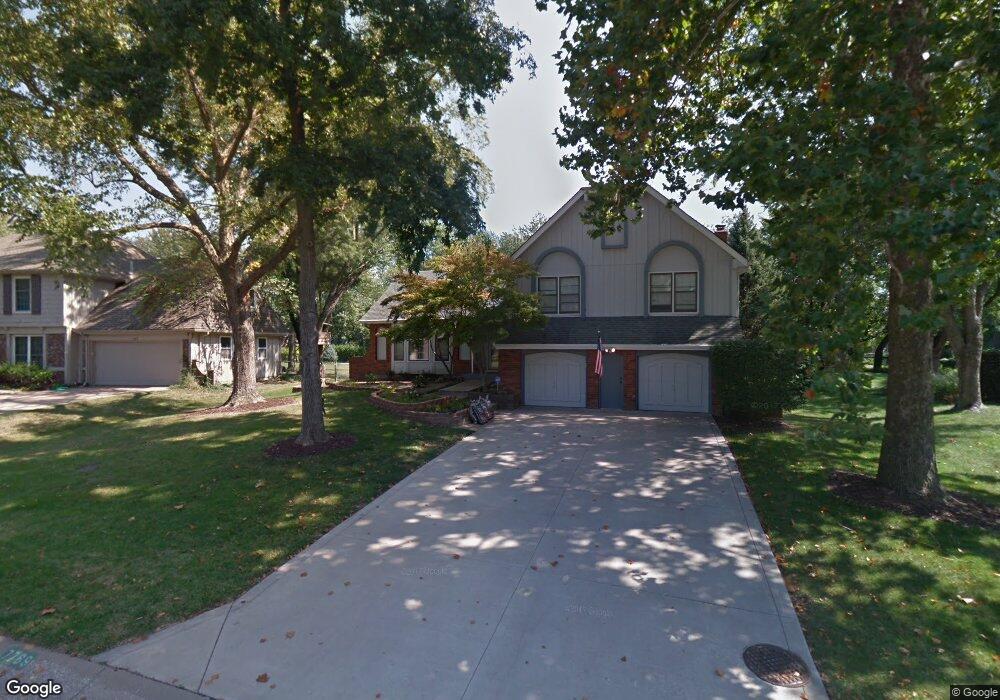
7769 Rosehill Rd Shawnee, KS 66216
Estimated Value: $408,525 - $441,000
4
Beds
3
Baths
1,710
Sq Ft
$246/Sq Ft
Est. Value
About This Home
This home is located at 7769 Rosehill Rd, Shawnee, KS 66216 and is currently estimated at $421,131, approximately $246 per square foot. 7769 Rosehill Rd is a home located in Johnson County with nearby schools including Mill Creek Elementary School, Trailridge Middle School, and Shawnee Mission Northwest High School.
Ownership History
Date
Name
Owned For
Owner Type
Purchase Details
Closed on
May 10, 2022
Sold by
Lamb Tige B and Lamb Vickie L
Bought by
Lamb Tige B and Lamb Vickie L
Current Estimated Value
Purchase Details
Closed on
Dec 6, 2005
Sold by
Roby Mary I and Roby Scott D
Bought by
Lamb Tige B and Lamb Vickie L
Home Financials for this Owner
Home Financials are based on the most recent Mortgage that was taken out on this home.
Original Mortgage
$161,200
Interest Rate
6.29%
Mortgage Type
New Conventional
Create a Home Valuation Report for This Property
The Home Valuation Report is an in-depth analysis detailing your home's value as well as a comparison with similar homes in the area
Home Values in the Area
Average Home Value in this Area
Purchase History
| Date | Buyer | Sale Price | Title Company |
|---|---|---|---|
| Lamb Tige B | -- | None Listed On Document | |
| Lamb Tige B | -- | Chicago Title Ins Co |
Source: Public Records
Mortgage History
| Date | Status | Borrower | Loan Amount |
|---|---|---|---|
| Previous Owner | Lamb Tige B | $161,200 |
Source: Public Records
Tax History Compared to Growth
Tax History
| Year | Tax Paid | Tax Assessment Tax Assessment Total Assessment is a certain percentage of the fair market value that is determined by local assessors to be the total taxable value of land and additions on the property. | Land | Improvement |
|---|---|---|---|---|
| 2024 | $4,855 | $43,895 | $8,251 | $35,644 |
| 2023 | $4,811 | $42,734 | $7,860 | $34,874 |
| 2022 | $4,407 | $39,111 | $7,146 | $31,965 |
| 2021 | $4,056 | $34,144 | $6,500 | $27,644 |
| 2020 | $4,016 | $33,477 | $6,500 | $26,977 |
| 2019 | $3,754 | $31,257 | $5,421 | $25,836 |
| 2018 | $3,627 | $29,923 | $5,421 | $24,502 |
| 2017 | $3,574 | $28,578 | $4,921 | $23,657 |
| 2016 | $3,405 | $26,875 | $4,725 | $22,150 |
| 2015 | $3,211 | $25,507 | $4,725 | $20,782 |
| 2013 | -- | $22,873 | $4,725 | $18,148 |
Source: Public Records
Map
Nearby Homes
- 7818 Westgate Dr
- 7736 Westgate Dr
- 7904 Rosehill Rd
- 7805 Long Ave
- 7917 Westgate Dr
- 8011 Gillette St
- 12212 W 79th Terrace
- 7913 Colony Ln
- 7526 Monrovia St
- 12808 W 82nd St
- 8215 Rosehill Rd
- 12557 W 82nd Terrace
- 7502 Monrovia St
- 7514 Caenen Lake Rd
- 13004 W 74th Terrace
- 8277 Monrovia St
- 11926 W 82nd Terrace
- 11924 W 82nd Terrace
- 13136 W 84th St
- 12403 W 72nd Terrace
- 7763 Rosehill Rd
- 7775 Rosehill Rd
- 7845 Rosehill Rd
- 7757 Rosehill Rd
- 7764 Rosehill Rd
- 7772 Rosehill Rd
- 7810 Westgate Dr
- 7814 Westgate Dr
- 7806 Westgate Dr
- 7780 Rosehill Rd
- 7751 Rosehill Rd
- 7853 Rosehill Rd
- 7842 Rosehill Rd
- 7802 Westgate Dr
- 12702 W 79th St
- 12800 W 77th Terrace
- 7822 Westgate Dr
- 7740 Westgate Dr
- 12818 W 78th Terrace
- 12809 W 77th Terrace