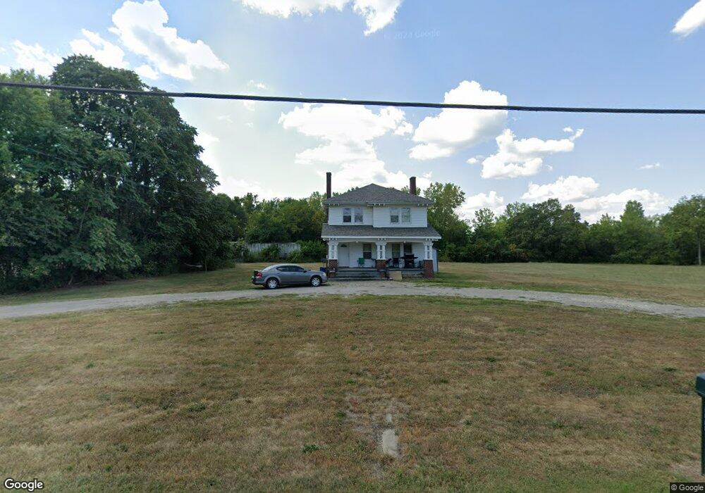
8099 Broadwell Rd Cincinnati, OH 45244
Estimated Value: $206,000 - $293,000
3
Beds
1
Bath
1,436
Sq Ft
$175/Sq Ft
Est. Value
About This Home
This home is located at 8099 Broadwell Rd, Cincinnati, OH 45244 and is currently estimated at $250,802, approximately $174 per square foot. 8099 Broadwell Rd is a home located in Hamilton County with nearby schools including Mercer Elementary School, Nagel Middle School, and Turpin High School.
Ownership History
Date
Name
Owned For
Owner Type
Purchase Details
Closed on
Nov 4, 2016
Sold by
Bee Holdings Ltd Ptshp
Bought by
Ancor Rental Co Llc
Current Estimated Value
Purchase Details
Closed on
Mar 22, 2006
Sold by
National City Home Loan Services Inc
Bought by
Bee Holdings Lp
Purchase Details
Closed on
Jun 10, 2005
Sold by
Murray William and Murray Louis J
Bought by
National City Home Loan Services Inc
Purchase Details
Closed on
Dec 18, 2002
Sold by
Murray Military & Historical Museum Inc
Bought by
Murray Louise J and Murray William J
Create a Home Valuation Report for This Property
The Home Valuation Report is an in-depth analysis detailing your home's value as well as a comparison with similar homes in the area
Home Values in the Area
Average Home Value in this Area
Purchase History
| Date | Buyer | Sale Price | Title Company |
|---|---|---|---|
| Ancor Rental Co Llc | -- | -- | |
| Bee Holdings Lp | $134,500 | Preferred Choice Title Svcs | |
| National City Home Loan Services Inc | $94,000 | None Available | |
| Murray Louise J | -- | -- |
Source: Public Records
Tax History Compared to Growth
Tax History
| Year | Tax Paid | Tax Assessment Tax Assessment Total Assessment is a certain percentage of the fair market value that is determined by local assessors to be the total taxable value of land and additions on the property. | Land | Improvement |
|---|---|---|---|---|
| 2024 | $3,762 | $55,125 | $8,435 | $46,690 |
| 2023 | $3,297 | $55,125 | $8,435 | $46,690 |
| 2022 | $2,007 | $29,737 | $8,341 | $21,396 |
| 2021 | $1,996 | $29,737 | $8,341 | $21,396 |
| 2020 | $1,974 | $29,737 | $8,341 | $21,396 |
| 2019 | $1,933 | $26,317 | $7,382 | $18,935 |
| 2018 | $1,814 | $26,317 | $7,382 | $18,935 |
| 2017 | $1,734 | $26,317 | $7,382 | $18,935 |
| 2016 | $2,053 | $30,191 | $7,161 | $23,030 |
| 2015 | $1,899 | $30,191 | $7,161 | $23,030 |
| 2014 | $1,899 | $30,191 | $7,161 | $23,030 |
| 2013 | $1,853 | $31,126 | $7,382 | $23,744 |
Source: Public Records
Map
Nearby Homes
- 0 Pearl St Unit 1225343
- 0 Pearl St Unit 1841806
- 3975 Mount Carmel Rd
- 3 Noel Ln
- 7976 Ashley View Dr
- 4885 Beechwood Rd
- 831 Douglas Ave
- 814 Floral Ave
- 765 Wooster Pike
- 5055 Drake Rd
- 481 Big Moe Dr
- 580 Lang Rd
- 8217 Wycliffe Dr
- 7222 English Dr Unit 6305
- 473 Richard Ln
- 9280 Indian Hill Rd
- 7124 Thorndale Ln
- 7411 Elm St
- 7408 Orchard St
- 7404 Orchard St
- 8121 Broadwell Rd
- 8121 Broadwell Rd
- 8067 Broadwell Rd
- 8131 Broadwell Rd
- 8057 Broadwell Rd
- 8139 Broadwell Rd
- 8155 Broadwell Rd
- 8161 Broadwell Rd
- 7973 Broadwell Rd
- 7968 Broadwell Rd
- 0 Round Bottom Rd Unit 1358581
- 4178 Round Bottom Rd
- 4138 Round Bottom Rd
- 4138 Round Bottom Rd
- 4138 Round Bottom Rd
- 4138 Round Bottom Rd
- 4207 Round Bottom Rd
- 4162 Round Bottom Rd
- 4217 Round Bottom Rd
- 4150 Round Bottom Rd