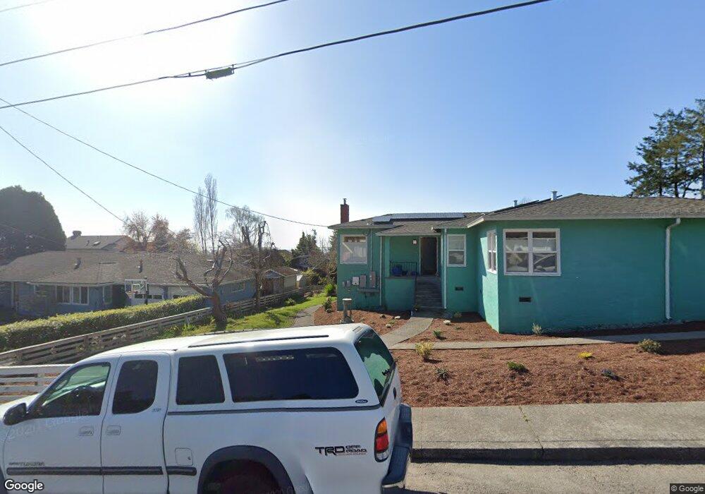
839 Spring St Arcata, CA 95521
East Arcata-Bay View NeighborhoodEstimated Value: $457,000 - $564,870
Studio
--
Bath
--
Sq Ft
10,019
Sq Ft Lot
About This Home
This home is located at 839 Spring St, Arcata, CA 95521 and is currently estimated at $517,968. 839 Spring St is a home with nearby schools including Arcata Elementary School, Sunny Brae Middle School, and Arcata High School.
Ownership History
Date
Name
Owned For
Owner Type
Purchase Details
Closed on
Aug 29, 2024
Sold by
Macdonald Roger F and Macdonald Dina M
Bought by
Macdonald Trust and Macdonald
Current Estimated Value
Purchase Details
Closed on
May 27, 2014
Sold by
Blakemore Peter and Estate Of Clarence S Howe
Bought by
Macdonald Roger F and Macdonald Dina M
Home Financials for this Owner
Home Financials are based on the most recent Mortgage that was taken out on this home.
Original Mortgage
$220,000
Interest Rate
4.17%
Mortgage Type
New Conventional
Create a Home Valuation Report for This Property
The Home Valuation Report is an in-depth analysis detailing your home's value as well as a comparison with similar homes in the area
Home Values in the Area
Average Home Value in this Area
Purchase History
| Date | Buyer | Sale Price | Title Company |
|---|---|---|---|
| Macdonald Trust | -- | None Listed On Document | |
| Macdonald Roger F | $275,000 | Humboldt Land Title Company |
Source: Public Records
Mortgage History
| Date | Status | Borrower | Loan Amount |
|---|---|---|---|
| Previous Owner | Macdonald Roger F | $220,000 |
Source: Public Records
Tax History
| Year | Tax Paid | Tax Assessment Tax Assessment Total Assessment is a certain percentage of the fair market value that is determined by local assessors to be the total taxable value of land and additions on the property. | Land | Improvement |
|---|---|---|---|---|
| 2025 | $3,814 | $337,097 | $196,130 | $140,967 |
| 2024 | $3,814 | $330,488 | $192,285 | $138,203 |
| 2023 | $3,734 | $324,009 | $188,515 | $135,494 |
| 2022 | $3,801 | $317,657 | $184,819 | $132,838 |
| 2021 | $3,621 | $311,430 | $181,196 | $130,234 |
| 2020 | $3,568 | $308,238 | $179,339 | $128,899 |
| 2019 | $3,453 | $302,195 | $175,823 | $126,372 |
| 2018 | $3,373 | $296,271 | $172,376 | $123,895 |
| 2017 | $3,304 | $290,463 | $168,997 | $121,466 |
| 2016 | $3,199 | $284,769 | $165,684 | $119,085 |
| 2015 | $3,163 | $280,493 | $163,196 | $117,297 |
| 2014 | $3,963 | $345,000 | $175,000 | $170,000 |
Source: Public Records
Map
Nearby Homes
- 120 & 120a 13th St
- 751 Patrick Ct
- 632 9th St
- 753 Shirley Blvd
- 57 & 77 F St
- 16 & 46 G St
- 1524 Beverly Dr
- 119 Sylva St
- 113 Sylva St
- 330 California Ave
- 1754 Virginia Way
- 1096 Diamond Dr
- 2700 Meadow Creek Way
- 1666 Stewart Ave
- 1346 Diamond Dr
- 812 Diamond Dr
- 2328 Sherri Ct
- 3122 St Louis Rd
- 1254 Mccallum Cir
- 3028 Alliance Rd
Your Personal Tour Guide
Ask me questions while you tour the home.