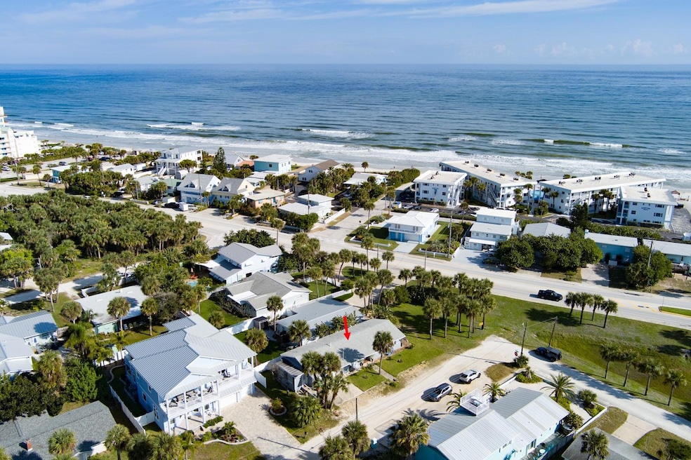
922 Locust St New Smyrna Beach, FL 32169
Central Beach NeighborhoodEstimated payment $4,671/month
Highlights
- Beach Access
- City View
- Wood Flooring
- Coronado Beach Elementary School Rated 9+
- Property is near public transit
- 4-minute walk to Marianne Clancy Park
About This Home
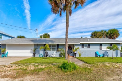
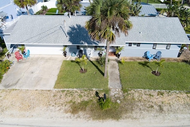
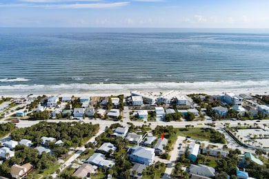
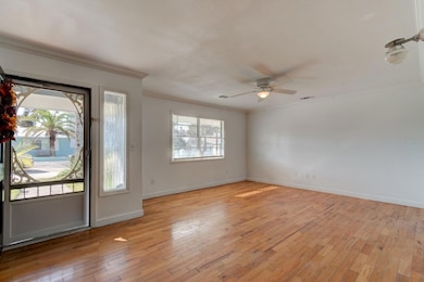
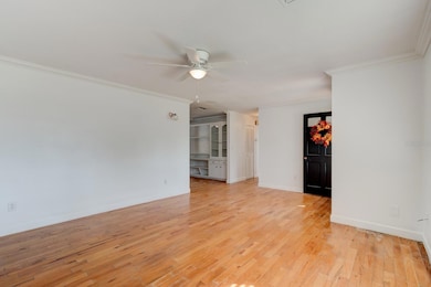
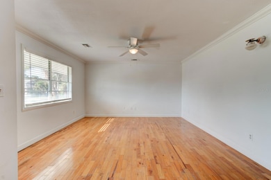
Welcome to 922 Locust Avenue, an exceptional Central Beachside property located just steps from the shoreline in one of the most desirable and walkable areas of New Smyrna Beach. From this address you can reach the nearest beach access within moments, giving you effortless daily enjoyment of sunrise walks, surf sessions, and evening shoreline sunsets. The home benefits from a serene park like conservation area positioned between the property and Atlantic Avenue, offering a unique natural buffer and added privacy this close to the ocean. The interior provides a flexible layout with a two bedroom and two bathroom main residence connected by a short hallway to a private one bedroom and one bathroom suite, ideal for an in law arrangement, extended guests, or a separate living space, all functioning easily as a three bedroom three bathroom residence supported by a two car garage. Some major components already updated including a new roof, a newer air conditioning system, and a newer water heater, giving the next owner a strong foundation to build on. Hardwood floors throughout the home are ready to be refinished and offer tremendous design potential, and the kitchen and bathrooms are well poised for the right buyer to personalize the space entirely to their own taste. Located in high and dry Flood Zone X and no flood history, the property stands out as a stable long term investment. For buyers considering redevelopment, the site offers excellent potential for a future multimillion dollar home with prospects for upper level ocean views due to its extremely close proximity to the beach and surrounding newer construction. The sellers are extremely motivated and invite all reasonable offers. Whether you choose to refresh the interior, utilize the flexible suite layout, or explore a complete rebuild, 922 Locust Avenue delivers rare location, land value, and long term upside in one of New Smyrna Beach’s most sought after coastal neighborhoods.
Listing Agent
HOME & FAMILY RE & PROP. MGMT Brokerage Phone: 386-690-6546 License #3043898 Listed on: 11/25/2025
Open House Schedule
-
Saturday, November 29, 202512:00 am to 3:00 pm11/29/2025 12:00:00 AM +00:0011/29/2025 3:00:00 PM +00:00Co-hosted by Professional Title New Smyrna BeachAdd to Calendar
Home Details
Home Type
- Single Family
Est. Annual Taxes
- $7,090
Year Built
- Built in 1974
Lot Details
- 5,520 Sq Ft Lot
- Lot Dimensions are 46x120
- Dirt Road
- South Facing Home
- Level Lot
- Cleared Lot
- Property is zoned 10R2
Parking
- 2 Car Attached Garage
- Oversized Parking
- Ground Level Parking
- Garage Door Opener
- Driveway
- On-Street Parking
- Off-Street Parking
Property Views
- City
- Garden
Home Design
- Slab Foundation
- Shingle Roof
- Block Exterior
Interior Spaces
- 1,642 Sq Ft Home
- 1-Story Property
- Ceiling Fan
- Window Treatments
- Living Room
- Inside Utility
- Fire and Smoke Detector
Kitchen
- Range
- Dishwasher
- Solid Wood Cabinet
Flooring
- Wood
- Tile
Bedrooms and Bathrooms
- 3 Bedrooms
- Split Bedroom Floorplan
- In-Law or Guest Suite
- 3 Full Bathrooms
Laundry
- Laundry Room
- Washer and Electric Dryer Hookup
Outdoor Features
- Beach Access
- Water access To Gulf or Ocean
- Property is near a marina
- Side Porch
Location
- Property is near public transit
Schools
- Coronado Beach Elementary School
- New Smyrna Beach Middl Middle School
- New Smyrna Beach High School
Utilities
- Central Heating and Cooling System
- Cable TV Available
Listing and Financial Details
- Visit Down Payment Resource Website
- Legal Lot and Block 95 / 08 - 00
- Assessor Parcel Number 7416-08-00-0950
Community Details
Overview
- No Home Owners Association
- Thoburns New Smyrna Beach Subdivision
- Near Conservation Area
Amenities
- Restaurant
Recreation
- Community Playground
- Park
Map
Home Values in the Area
Average Home Value in this Area
Tax History
| Year | Tax Paid | Tax Assessment Tax Assessment Total Assessment is a certain percentage of the fair market value that is determined by local assessors to be the total taxable value of land and additions on the property. | Land | Improvement |
|---|---|---|---|---|
| 2025 | $6,462 | $526,123 | $347,521 | $178,602 |
| 2024 | $6,462 | $527,806 | $347,521 | $180,285 |
| 2023 | $6,462 | $462,097 | $283,406 | $178,691 |
| 2022 | $5,784 | $411,587 | $271,791 | $139,796 |
| 2021 | $4,958 | $273,984 | $118,473 | $155,511 |
| 2020 | $5,151 | $314,256 | $163,075 | $151,181 |
| 2019 | $4,793 | $273,783 | $144,514 | $129,269 |
| 2018 | $4,536 | $262,291 | $144,514 | $117,777 |
| 2017 | $4,289 | $242,206 | $102,784 | $139,422 |
| 2016 | $4,210 | $225,787 | $0 | $0 |
| 2015 | $4,055 | $214,438 | $0 | $0 |
| 2014 | $3,722 | $191,018 | $0 | $0 |
Property History
| Date | Event | Price | List to Sale | Price per Sq Ft |
|---|---|---|---|---|
| 11/25/2025 11/25/25 | For Sale | $775,000 | -- | $534 / Sq Ft |
Purchase History
| Date | Type | Sale Price | Title Company |
|---|---|---|---|
| Warranty Deed | $238,000 | Watson Title Services Inc | |
| Warranty Deed | -- | -- | |
| Deed | $2,500 | -- |
Mortgage History
| Date | Status | Loan Amount | Loan Type |
|---|---|---|---|
| Open | $190,400 | Purchase Money Mortgage |
Source: Stellar MLS
MLS Number: NS1086704
APN: 7416-08-00-0950
Disclaimer: Certain information contained herein is derived from information provided by parties other than Homes.com. All information provided is deemed reliable, but is not guaranteed to be accurate and should be independently verified.
![]() IDX information is provided exclusively for personal, non-commercial use, and may not be used for any purpose other than to identify prospective properties consumers may be interested in purchasing. Information is deemed reliable but not guaranteed.
IDX information is provided exclusively for personal, non-commercial use, and may not be used for any purpose other than to identify prospective properties consumers may be interested in purchasing. Information is deemed reliable but not guaranteed.
Listing Information presented by local MLS brokerage: Ten-X - (888)-952-6393
- 923 Locust St
- 910 Locust St
- 905 E 1st Ave
- 1100 E 3rd Ave
- 910 Maple St Unit A & B
- 830 Maralyn Ave
- 833 Maralyn Ave
- 807 S Atlantic Ave Unit 402
- 701 S Atlantic Ave Unit 21
- 1571 S Atlantic Ave Unit 106
- 1571 S Atlantic Ave Unit 1060
- 611 S Atlantic Ave Unit 4612
- 611 S Atlantic Ave Unit 4212
- 1304 Saxon Dr
- 602 S Atlantic Ave
- 1504 Southard Ave
- 839 7th Ave
- 423 S Atlantic Ave Unit 301
- 423 S Atlantic Ave Unit 101
- 423 S Atlantic Ave Unit 102
- 1011 Hill St
- 910 Maple St Unit A
- 711 S Atlantic Ave Unit 701
- 801 E 2nd Ave
- 813 Hope Ave Unit 811
- 1504 Golden Ct
- 1571 S Atlantic Ave Unit 204
- 1571 S Atlantic Ave Unit 201
- 1571 S Atlantic Ave Unit 406
- 1571 S Atlantic Ave Unit 203
- 1571 S Atlantic Ave Unit 210
- 1571 S Atlantic Ave Unit 412
- 1571 S Atlantic Ave Unit 410
- 1571 S Atlantic Ave Unit 205
- 1571 S Atlantic Ave Unit 208
- 1571 S Atlantic Ave Unit 307
- 1571 S Atlantic Ave Unit 303
- 1571 S Atlantic Ave Unit 211
- 1571 S Atlantic Ave Unit 403
- 1571 S Atlantic Ave Unit 108
