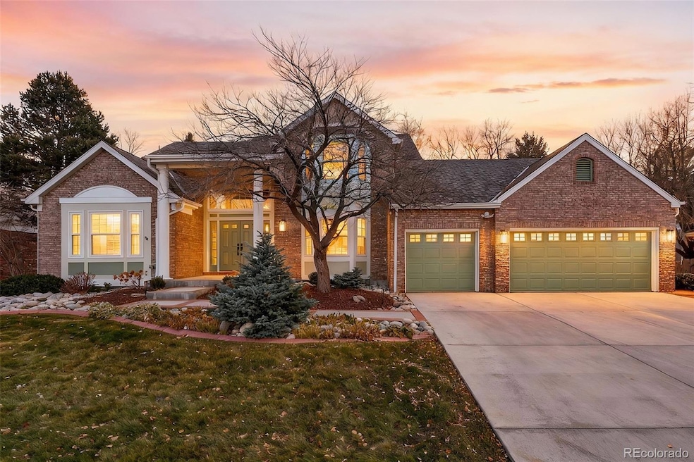
9222 W Brandt Ave Littleton, CO 80123
Governor's Ranch NeighborhoodEstimated payment $6,713/month
Highlights
- Popular Property
- Primary Bedroom Suite
- Fireplace in Bedroom
- Columbine High School Rated A
- Clubhouse
- Vaulted Ceiling
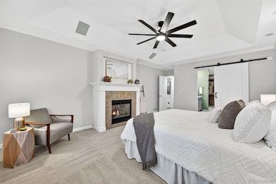
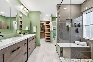
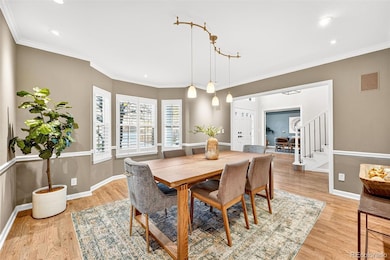
About This Home
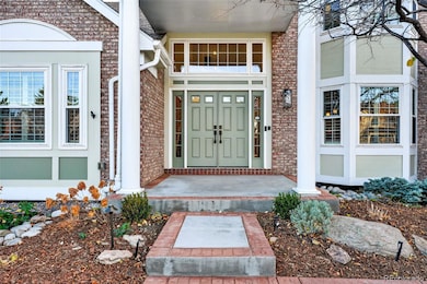
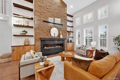
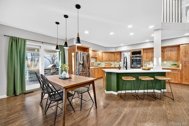
This is it- your chance to own the one and only builder's home in Governor's Ranch, which has undergone such an exceptional makeover, it is sure to captivate all who walk through the door. More than 5,100 square feet of exquisite, thoughtfully-updated, remodeled space- including four bedrooms, four bathrooms, two office bonus rooms, a 3-car garage and so much more. From the moment you pull up to this home you'll have all the feels- and with highlights like an indoor sauna, outdoor kitchen, movie theater-projector, and a mother-in-law-suite in the basement, you simply have to see this one to believe it- IT'S SO GOOD! The entryway alone is a show-stopper, but once inside, you'll find two-story vaulted ceilings, a plethora of natural light, an open floor plan that showcases the updated kitchen, a dramatic floor-to-ceiling stonework fireplace in the living room, designer finishes, fresh paint, new flooring, the list goes on. You'll enjoy the convenience of a main-floor primary suite; complete with its own gas fireplace, ensuite bathroom, dual vanities, and a huge walk-in closet. This home has formal dining, informal dining, office space, room for crafting, photography, hobbies of any shape! You can host movie nights, outdoor BBQs, retreat solo or with others in the sauna. This home is a lifestyle, and this lifestyle is no doubt the sweet life! The neighborhood of course comes with its own perks; including a clubhouse, pool, tennis courts, pickleball courts, a playground, and plenty of green space to enjoy. It's the community you'll love most when moving to Governor's Ranch, but having the house of your dreams is going to feel pretty great too! 9222 W Brandt Ave is the whole package. Come see for yourself!
Listing Agent
Compass - Denver Brokerage Email: amymartin@compass.com,720-297-8909 License #100106235 Listed on: 11/19/2025

Home Details
Home Type
- Single Family
Est. Annual Taxes
- $6,433
Year Built
- Built in 1993 | Remodeled
Lot Details
- 9,801 Sq Ft Lot
- Property is Fully Fenced
- Garden
- Property is zoned P-D
HOA Fees
- $115 Monthly HOA Fees
Parking
- 3 Car Attached Garage
Home Design
- Brick Exterior Construction
Interior Spaces
- 2-Story Property
- Vaulted Ceiling
- Living Room with Fireplace
- 2 Fireplaces
- Dining Room
- Home Office
- Bonus Room
- Utility Room
Kitchen
- Oven
- Microwave
- Dishwasher
- Disposal
Bedrooms and Bathrooms
- Fireplace in Bedroom
- Primary Bedroom Suite
- En-Suite Bathroom
Laundry
- Laundry Room
- Dryer
- Washer
Finished Basement
- Basement Fills Entire Space Under The House
- 1 Bedroom in Basement
Outdoor Features
- Fire Pit
- Exterior Lighting
- Outdoor Gas Grill
- Playground
Schools
- Governor's Ranch Elementary School
- Ken Caryl Middle School
- Columbine High School
Utilities
- Forced Air Heating and Cooling System
- Heating System Uses Natural Gas
Listing and Financial Details
- Exclusions: Seller`s personal property, staging furniture, artwork
- Assessor Parcel Number 407964
Community Details
Overview
- Governors Ranch HOA, Phone Number (303) 979-4822
- Governors Ranch Subdivision
Amenities
- Clubhouse
Recreation
- Tennis Courts
- Community Playground
- Community Pool
Map
Home Values in the Area
Average Home Value in this Area
Tax History
| Year | Tax Paid | Tax Assessment Tax Assessment Total Assessment is a certain percentage of the fair market value that is determined by local assessors to be the total taxable value of land and additions on the property. | Land | Improvement |
|---|---|---|---|---|
| 2024 | $6,430 | $65,657 | $15,709 | $49,948 |
| 2023 | $6,430 | $65,657 | $15,709 | $49,948 |
| 2022 | $5,411 | $54,247 | $14,467 | $39,780 |
| 2021 | $5,481 | $55,809 | $14,884 | $40,925 |
| 2020 | $5,080 | $51,849 | $13,091 | $38,758 |
| 2019 | $5,017 | $51,849 | $13,091 | $38,758 |
| 2018 | $4,468 | $44,589 | $10,963 | $33,626 |
| 2017 | $4,078 | $44,589 | $10,963 | $33,626 |
| 2016 | $3,867 | $40,796 | $10,771 | $30,025 |
| 2015 | $3,932 | $40,796 | $10,771 | $30,025 |
| 2014 | $3,932 | $38,905 | $9,254 | $29,651 |
Property History
| Date | Event | Price | List to Sale | Price per Sq Ft |
|---|---|---|---|---|
| 11/19/2025 11/19/25 | For Sale | $1,150,000 | -- | $242 / Sq Ft |
Purchase History
| Date | Type | Sale Price | Title Company |
|---|---|---|---|
| Interfamily Deed Transfer | -- | None Available | |
| Interfamily Deed Transfer | -- | None Available | |
| Warranty Deed | $610,000 | None Available | |
| Interfamily Deed Transfer | -- | None Available |
Source: REcolorado®
MLS Number: 5608224
APN: 59-153-02-014
Disclaimer: Certain information contained herein is derived from information provided by parties other than Homes.com. All information provided is deemed reliable, but is not guaranteed to be accurate and should be independently verified.
![]() The content relating to real estate for sale in this Web site comes in part from the Internet Data eXchange (“IDX”) program of METROLIST, INC., DBA RECOLORADO®. Real estate listings held by brokers other than Ten-X are marked with the IDX Logo. This information is being provided for the consumers’ personal, non-commercial use and may not be used for any other purpose. All information subject to change and should be independently verified.
The content relating to real estate for sale in this Web site comes in part from the Internet Data eXchange (“IDX”) program of METROLIST, INC., DBA RECOLORADO®. Real estate listings held by brokers other than Ten-X are marked with the IDX Logo. This information is being provided for the consumers’ personal, non-commercial use and may not be used for any other purpose. All information subject to change and should be independently verified.
This publication is designed to provide information with regard to the subject matter covered. It is displayed with the understanding that the publisher and authors are not engaged in rendering real estate, legal, accounting, tax, or other professional services and that the publisher and authors are not offering such advice in this publication. If real estate, legal, or other expert assistance is required, the services of a competent, professional person should be sought.
The information contained in this publication is subject to change without notice. METROLIST, INC., DBA RECOLORADO MAKES NO WARRANTY OF ANY KIND WITH REGARD TO THIS MATERIAL, INCLUDING, BUT NOT LIMITED TO, THE IMPLIED WARRANTIES OF MERCHANTABILITY AND FITNESS FOR A PARTICULAR PURPOSE. METROLIST, INC., DBA RECOLORADO SHALL NOT BE LIABLE FOR ERRORS CONTAINED HEREIN OR FOR ANY DAMAGES IN CONNECTION WITH THE FURNISHING, PERFORMANCE, OR USE OF THIS MATERIAL.
PUBLISHER’S NOTICE: All real estate advertised herein is subject to the Federal Fair Housing Act and the Colorado Fair Housing Act, which Acts make it illegal to make or publish any advertisement that indicates any preference, limitation, or discrimination based on race, color, religion, sex, handicap, familial status, or national origin.
METROLIST, INC., DBA RECOLORADO will not knowingly accept any advertising for real estate that is in violation of the law. All persons are hereby informed that all dwellings advertised are available on an equal opportunity basis.
© 2025 METROLIST, INC., DBA RECOLORADO® – All Rights Reserved. 6455 S. Yosemite St., Suite 500 Greenwood Village, CO 80111 USA
ALL RIGHTS RESERVED WORLDWIDE. No part of this publication may be reproduced, adapted, translated, stored in a retrieval system or transmitted in any form or by any means, electronic, mechanical, photocopying, recording, or otherwise, without the prior written permission of the publisher. The information contained herein including but not limited to all text, photographs, digital images, virtual tours, may be seeded and monitored for protection and tracking.
- 5520 S Jellison St
- 9614 W Arlington Ave
- 9895 W Powers Cir
- 5310 S Jellison St
- 8775 W Berry Ave Unit 203
- 5415 S Dover St Unit 104
- 8755 W Berry Ave Unit 201
- 5264 S Jellison St
- 5520 S Kline St
- 9684 W Long Dr
- 8896 W Prentice Ave
- 5289 S Cody St
- 5307 S Cody St
- 10201 W Ida Ave Unit 146
- 9950 W Progress Place
- 5341 S Cody St
- 9161 W Lake Dr
- 5915 S Dover Ct
- 5976 S Jellison St Unit E
- 4962 S Field Ct
- 9097 W Cross Dr
- 5906 S Jellison St
- 5543 S Moore St
- 4899 S Dudley St Unit 14F
- 9212 W Arbor Ave
- 8963 W Arbor Ave
- 8012 W Long Dr
- 13195 W Progress Cir Unit FL1-ID593A
- 13195 W Progress Cir Unit FL2-ID315A
- 13195 W Progress Cir Unit FL3-ID564A
- 13195 W Progress Cir Unit FL2-ID508A
- 13195 W Progress Cir Unit FL2-ID306A
- 13195 W Progress Cir Unit FL3-ID935A
- 13195 W Progress Cir Unit FL3-ID2004A
- 13195 W Progress Cir Unit FL1-ID279A
- 13195 W Progress Cir Unit FL2-ID1341A
- 13195 W Progress Cir Unit FL1-ID1908A
- 10587 W Maplewood Dr Unit C
- 4601 S Balsam Way
- 5051 S Robb Ct