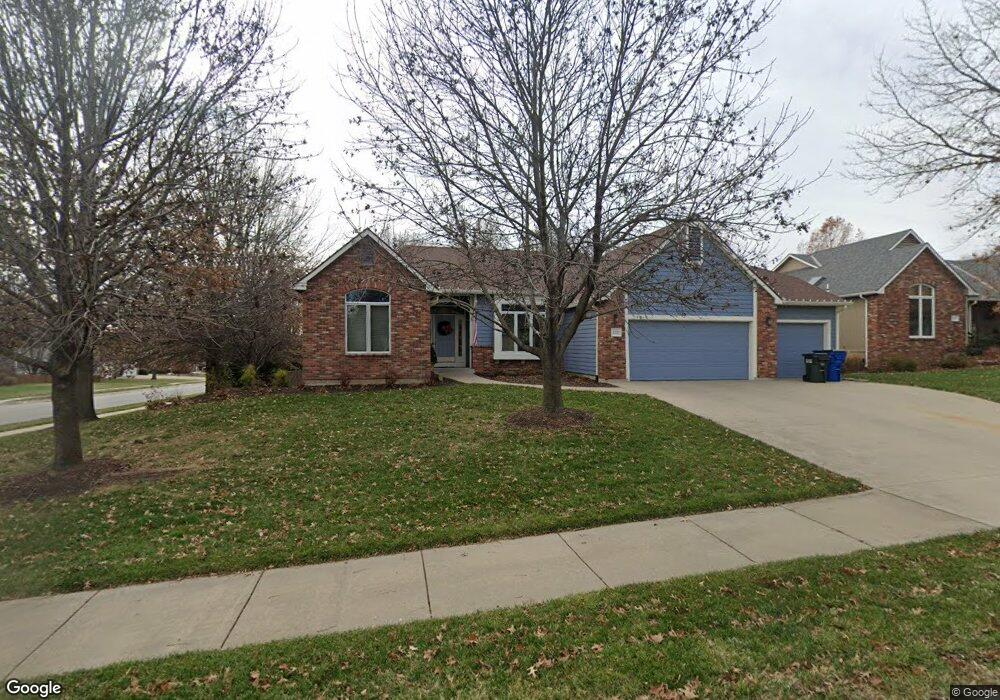
1021 Langston Ct Lawrence, KS 66049
West Lawrence NeighborhoodEstimated Value: $554,000 - $618,000
4
Beds
3
Baths
2,546
Sq Ft
$227/Sq Ft
Est. Value
About This Home
This home is located at 1021 Langston Ct, Lawrence, KS 66049 and is currently estimated at $578,995, approximately $227 per square foot. 1021 Langston Ct is a home located in Douglas County with nearby schools including Langston Hughes Elementary School, Southwest Middle School, and Lawrence Free State High School.
Ownership History
Date
Name
Owned For
Owner Type
Purchase Details
Closed on
Apr 14, 2022
Sold by
William C Barteldes Revocable Trust
Bought by
Kelley Peter J
Current Estimated Value
Purchase Details
Closed on
Sep 15, 2008
Sold by
Barteldes William C
Bought by
Barteldes William C and William C Barteldes Revocable
Create a Home Valuation Report for This Property
The Home Valuation Report is an in-depth analysis detailing your home's value as well as a comparison with similar homes in the area
Home Values in the Area
Average Home Value in this Area
Purchase History
| Date | Buyer | Sale Price | Title Company |
|---|---|---|---|
| Kelley Peter J | -- | None Listed On Document | |
| Barteldes William C | -- | None Available |
Source: Public Records
Tax History Compared to Growth
Tax History
| Year | Tax Paid | Tax Assessment Tax Assessment Total Assessment is a certain percentage of the fair market value that is determined by local assessors to be the total taxable value of land and additions on the property. | Land | Improvement |
|---|---|---|---|---|
| 2025 | $7,997 | $63,710 | $9,200 | $54,510 |
| 2024 | $7,714 | $61,468 | $7,475 | $53,993 |
| 2023 | $7,932 | $61,226 | $7,475 | $53,751 |
| 2022 | $6,715 | $51,566 | $7,475 | $44,091 |
| 2021 | $6,129 | $45,724 | $6,334 | $39,390 |
| 2020 | $5,977 | $44,827 | $6,334 | $38,493 |
| 2019 | $5,689 | $42,722 | $6,334 | $36,388 |
| 2018 | $5,686 | $42,389 | $6,334 | $36,055 |
| 2017 | $5,616 | $41,406 | $6,334 | $35,072 |
| 2016 | $5,214 | $40,158 | $5,753 | $34,405 |
| 2015 | $2,652 | $40,848 | $5,753 | $35,095 |
| 2014 | $2,627 | $40,848 | $5,753 | $35,095 |
Source: Public Records
Map
Nearby Homes
- 5117 Harvard Rd
- 1040 Stonecreek Dr
- 1017 Stoneridge Dr
- 1033 Stonecreek Dr
- 5204 Foxchase Dr
- 5204 Fox Chase Dr
- 5024 Cedar Grove Way
- 1202 Little Knife
- 1300 Research Park Dr
- 1315 Research Park Dr
- 5245 Overland Dr Unit A15
- 5245 Overland Dr Unit C12
- 5245 Overland Dr Unit D4
- 1347 Kanza Dr
- 904 Moundridge Dr
- 5614 Chimney Rocks Cir
- 5710 Goff Ct
- 6204 Berando Ct
- 1564 Fountain Dr
- 311 Headwaters Dr
- 1017 Langston Ct
- 1116 Stoneridge Dr
- 1016 Langston Ct
- 5217 Harvard Rd
- 1013 Langston Ct
- 1112 Stoneridge Dr
- 1012 Langston Ct
- 1128 Summerfield Way
- 5213 Harvard Rd
- 1121 Summerfield Way
- 5208 Harvard Rd
- 1009 Langston Ct
- 1124 Summerfield Way
- 5209 Harvard Rd
- 1121 Stoneridge Dr
- 1008 Langston Ct
- 5221 Harvard Rd
- 1117 Stoneridge Dr
- 1005 Langston Ct
- 1104 Stoneridge Dr