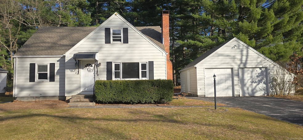
14 W Forrest Dr Enfield, CT 06082
Estimated payment $2,388/month
Highlights
- Cape Cod Architecture
- Patio
- Hot Water Heating System
- 1 Fireplace
- Hot Water Circulator
About This Home
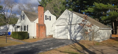
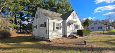
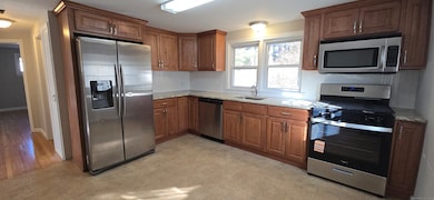
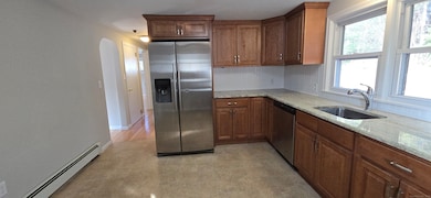
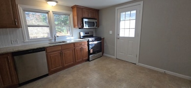
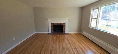
Welcome home to this charming Cape set on a quiet, established, wooded street just minutes from local conveniences. Warm wood floors flow throughout the finished areas, anchored by a cozy fireplaced living room-perfect for gatherings or relaxing evenings at home. The eat-in kitchen appointed with granite counters offers a comfortable daily hub, and the flexible layout includes additional upstairs space already framed for valuable expansion potential for 4th bedroom and bath/closet. A detached 2-bay garage provides great car storage, hobby, or workshop options, and a new roof offers peace of mind for years to come. You're also close to Enfield's robust park and open-space system, with easy access to Scantic River State Park, nature trails, the Windsor Locks Canal multi-use path, and Grassmere Country Club for golf enthusiasts. All of this with unbeatable convenience to shopping, restaurants, and major interstates, making commuting and daily errands a breeze. A great opportunity to bring your vision and make this home shine.
Listing Agent
Coldwell Banker Realty Brokerage Phone: (860) 604-8723 License #REB.0318301 Listed on: 11/24/2025

Home Details
Home Type
- Single Family
Est. Annual Taxes
- $5,222
Year Built
- Built in 1953
Lot Details
- 0.46 Acre Lot
- Property is zoned R33
Parking
- 2 Car Garage
Home Design
- Cape Cod Architecture
- Concrete Foundation
- Frame Construction
- Asphalt Shingled Roof
- Aluminum Siding
- Vinyl Siding
Interior Spaces
- 1,462 Sq Ft Home
- 1 Fireplace
- Unfinished Basement
- Basement Fills Entire Space Under The House
- Laundry on lower level
Kitchen
- Oven or Range
- Microwave
- Dishwasher
Bedrooms and Bathrooms
- 3 Bedrooms
- 1 Full Bathroom
Outdoor Features
- Patio
Utilities
- Hot Water Heating System
- Heating System Uses Oil
- Private Company Owned Well
- Hot Water Circulator
- Fuel Tank Located in Basement
Listing and Financial Details
- Assessor Parcel Number 539429
Map
Home Values in the Area
Average Home Value in this Area
Tax History
| Year | Tax Paid | Tax Assessment Tax Assessment Total Assessment is a certain percentage of the fair market value that is determined by local assessors to be the total taxable value of land and additions on the property. | Land | Improvement |
|---|---|---|---|---|
| 2025 | $5,222 | $150,700 | $53,200 | $97,500 |
| 2024 | $5,095 | $150,700 | $53,200 | $97,500 |
| 2023 | $5,012 | $150,700 | $53,200 | $97,500 |
| 2022 | $46 | $150,700 | $53,200 | $97,500 |
| 2021 | $4,450 | $119,040 | $44,110 | $74,930 |
| 2020 | $4,450 | $119,040 | $44,110 | $74,930 |
| 2019 | $4,450 | $119,040 | $44,110 | $74,930 |
| 2018 | $4,351 | $119,040 | $44,110 | $74,930 |
| 2017 | $4,116 | $119,040 | $44,110 | $74,930 |
| 2016 | $3,992 | $117,370 | $44,110 | $73,260 |
| 2015 | $2,181 | $117,370 | $44,110 | $73,260 |
| 2014 | $3,789 | $117,370 | $44,110 | $73,260 |
Property History
| Date | Event | Price | List to Sale | Price per Sq Ft |
|---|---|---|---|---|
| 11/24/2025 11/24/25 | For Sale | $369,900 | -- | $253 / Sq Ft |
Purchase History
| Date | Type | Sale Price | Title Company |
|---|---|---|---|
| Foreclosure Deed | -- | -- | |
| Warranty Deed | $210,000 | -- | |
| Foreclosure Deed | -- | -- | |
| Warranty Deed | $210,000 | -- |
Mortgage History
| Date | Status | Loan Amount | Loan Type |
|---|---|---|---|
| Previous Owner | $206,755 | No Value Available |
Source: SmartMLS
MLS Number: 24142095
APN: ENFI-000077-000000-000036
Disclaimer: Certain information contained herein is derived from information provided by parties other than Homes.com. All information provided is deemed reliable, but is not guaranteed to be accurate and should be independently verified.
![]() IDX information is provided exclusively for personal, non-commercial use, and may not be used for any purpose other than to identify prospective properties consumers may be interested in purchasing. Information is deemed reliable but not guaranteed.
IDX information is provided exclusively for personal, non-commercial use, and may not be used for any purpose other than to identify prospective properties consumers may be interested in purchasing. Information is deemed reliable but not guaranteed.
- 39 Liberty Ln
- 41 Liberty Ln
- 43 Liberty Ln
- 50 Liberty Ln
- 12 Concord Terrace
- 6 Jondot Dr
- 5 Cranberry Hollow Unit 5
- 35 Roosevelt Blvd
- 25 Whitmun Rd
- 757 Shaker Rd
- 151 Wolf Swamp Rd
- 408 Maple Rd
- 32 Magnolia Dr
- 30 Alban Rd
- 90 Cottage Rd
- 176 Cottage Rd
- 49 Wimbleton Dr
- 65 W Shore Dr
- 12 the Laurels Unit 12
- 136 Fenwood Rd
- 1 Gardners Way
- 81 The Meadows Unit 81
- 31 Whitmun Rd
- 131 Shaker Rd
- 235 Shaker Rd
- 124 Barrington Rd
- 168 Fox Hill Ln
- 31 Francis Ave
- 37 School St
- 22 Ohear Ave
- 15 Yorktown Dr
- 61 Jamestown Dr Unit 61
- 20 Smithfield Ct Unit 2
- 10 Russell St
- 27 Bunker Cir
- 55 Main St
- 12 Walnut St
- 415 Porter Lake Dr
- 7 Mcconn Ave
- 37 New King St