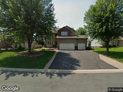
1904 Mooers Ave Shakopee, MN 55379
Estimated Value: $527,941 - $560,000
5
Beds
4
Baths
2,532
Sq Ft
$213/Sq Ft
Est. Value
About This Home
This home is located at 1904 Mooers Ave, Shakopee, MN 55379 and is currently estimated at $538,485, approximately $212 per square foot. 1904 Mooers Ave is a home located in Scott County with nearby schools including Sun Path Elementary School, Shakopee West Middle School, and Shakopee Senior High School.
Ownership History
Date
Name
Owned For
Owner Type
Purchase Details
Closed on
Aug 2, 2016
Sold by
Turcotte Scott and Turcotte Erin
Bought by
Murphy Terrence D and Murphy Gina M
Current Estimated Value
Home Financials for this Owner
Home Financials are based on the most recent Mortgage that was taken out on this home.
Original Mortgage
$282,000
Outstanding Balance
$182,682
Interest Rate
3.56%
Mortgage Type
New Conventional
Estimated Equity
$355,803
Purchase Details
Closed on
May 27, 2004
Sold by
Sharp Eric A and Sharp Sally J
Bought by
Turcotte Erin E and Turcotte Scott D
Purchase Details
Closed on
Oct 31, 2001
Sold by
U S Home Corp
Bought by
Sharp Eric A and Sharp Sally J
Create a Home Valuation Report for This Property
The Home Valuation Report is an in-depth analysis detailing your home's value as well as a comparison with similar homes in the area
Home Values in the Area
Average Home Value in this Area
Purchase History
| Date | Buyer | Sale Price | Title Company |
|---|---|---|---|
| Murphy Terrence D | $378,000 | All American Title Company | |
| Turcotte Erin E | $309,000 | -- | |
| Sharp Eric A | $243,955 | -- |
Source: Public Records
Mortgage History
| Date | Status | Borrower | Loan Amount |
|---|---|---|---|
| Open | Murphy Terrence D | $282,000 | |
| Previous Owner | Turcotte Scott | $289,450 | |
| Previous Owner | Turcotte Scott D | $324,000 | |
| Previous Owner | Turcotte Scott | $314,500 |
Source: Public Records
Tax History Compared to Growth
Tax History
| Year | Tax Paid | Tax Assessment Tax Assessment Total Assessment is a certain percentage of the fair market value that is determined by local assessors to be the total taxable value of land and additions on the property. | Land | Improvement |
|---|---|---|---|---|
| 2025 | $5,114 | $492,600 | $143,600 | $349,000 |
| 2024 | $5,114 | $497,600 | $143,600 | $354,000 |
| 2023 | $5,370 | $477,600 | $138,100 | $339,500 |
| 2022 | $4,854 | $492,300 | $156,900 | $335,400 |
| 2021 | $4,128 | $383,000 | $122,000 | $261,000 |
| 2020 | $4,524 | $357,400 | $117,000 | $240,400 |
| 2019 | $4,604 | $344,500 | $104,000 | $240,500 |
| 2018 | $5,050 | $0 | $0 | $0 |
| 2016 | $4,908 | $0 | $0 | $0 |
| 2014 | -- | $0 | $0 | $0 |
Source: Public Records
Map
Nearby Homes
- 1986 Mathias Rd
- 1815 Mooers Ave
- 2179 Ponds Way
- 2052 Wilhelm Ct
- 1780 Quail Dr
- 2374 Thrush St
- 2330 Ponds Way
- 1874 Pintail Ave
- 1971 Evergreen Ln
- 2011 Downing Ave
- 1938 Ormond Dr
- 2230 Downing Ave
- 2550 Downing Ave
- 2127 Ormond Dr
- 2615 King Ave
- 2726 Green Ash Ave
- 2734 Green Ash Ave
- 2749 Green Ash Ave
- 2718 Green Ash Ave
- 1534 England Way
- 1904 Mooers Ave
- 1872 Mooers Ave
- 1918 Mooers Ave
- 1889 Mathias Rd
- 1935 Hazen St
- 1856 Mooers Ave
- 1933 Mathias Rd
- 1911 Mooers Ave
- 1943 Hazen St
- 1867 Mathias Rd
- 1895 Mooers Ave
- 1879 Mooers Ave
- 1951 Hazen St
- 1920 Mathias Rd
- 1863 Mooers Ave
- 1898 Mathias Rd
- 1955 Mathias Rd
- 1845 Mathias Rd
- 1847 Mooers Ave
- 1942 Mathias Rd