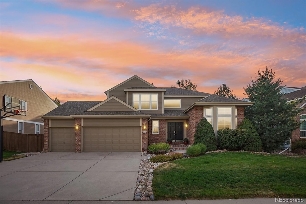
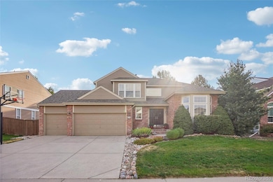
1993 Mountain Maple Ave Highlands Ranch, CO 80129
Westridge NeighborhoodEstimated payment $5,446/month
Highlights
- Primary Bedroom Suite
- Mountain View
- Private Yard
- Coyote Creek Elementary School Rated A-
- Wood Flooring
- Game Room
About This Home
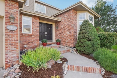
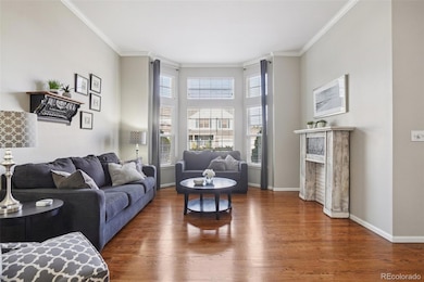
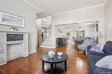
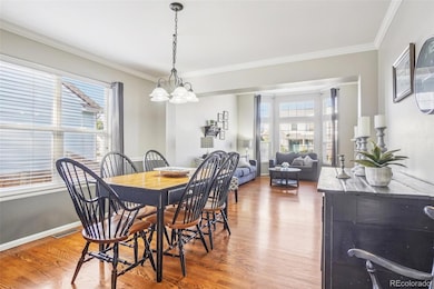
Stunning Sanford-Built Home in Westridge* 5 Bedrooms, 4 Bathrooms, Over 3300 Square Feet Finished* Real Hardwood Floors Throughout the Main Floor* Large Kitchen w/ Granite Countertops, Center Island, Walk-In Pantry and Stainless Steel Appliances* Finished Basement w/ Workout Area, 5th Bedroom or Office, Big-Screen TV w/ Built-In Surround Sound, and Room for a Pool Table or Ping-Pong Table*. The Primary Bedroom has Mountain Views and a Newly Remodeled Primary Bathroom* The Backyard has a Large, Concrete Patio and the Mature Trees Offer lots of Privacy* If you are Looking for a Home in Suburbia with Mature Landscaping and the Builder wasn't afraid to use brick... I would invite you to view this amazing home.
THIS HOME IS AVAILABLE FOR $444,600 AS A LEASEHOLD STRUCTURE.
Get the kind of home you've always wanted, but with a MUCH lower down payment!
Please call or text for more details. 303.521.6116
Listing Agent
RE/MAX Professionals Brokerage Phone: 303-771-9400 License #1168055 Listed on: 08/08/2025
Home Details
Home Type
- Single Family
Est. Annual Taxes
- $5,331
Year Built
- Built in 1997 | Remodeled
Lot Details
- 9,496 Sq Ft Lot
- West Facing Home
- Property is Fully Fenced
- Private Yard
- Property is zoned PDU
HOA Fees
- $57 Monthly HOA Fees
Parking
- 3 Car Attached Garage
Home Design
- Brick Exterior Construction
- Slab Foundation
- Composition Roof
- Wood Siding
- Concrete Perimeter Foundation
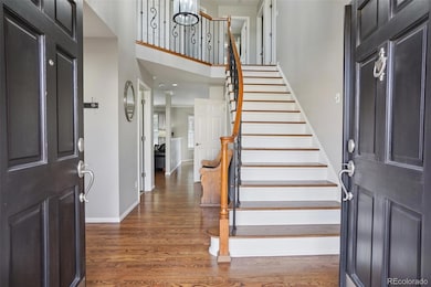
Interior Spaces
- 2-Story Property
- Wet Bar
- Furnished or left unfurnished upon request
- Sound System
- Ceiling Fan
- Double Pane Windows
- Window Treatments
- Bay Window
- Entrance Foyer
- Smart Doorbell
- Family Room with Fireplace
- Living Room
- Dining Room
- Game Room
- Workshop
- Home Gym
- Wood Flooring
- Mountain Views
- Fire and Smoke Detector
Kitchen
- Eat-In Kitchen
- Walk-In Pantry
- Self-Cleaning Oven
- Range
- Microwave
- Dishwasher
- Kitchen Island
- Disposal
Bedrooms and Bathrooms
- 5 Bedrooms
- Primary Bedroom Suite
- Walk-In Closet
Laundry
- Laundry Room
- Dryer
- Washer
Finished Basement
- Basement Fills Entire Space Under The House
- 1 Bedroom in Basement
Schools
- Coyote Creek Elementary School
- Ranch View Middle School
- Thunderridge High School
Utilities
- Forced Air Heating and Cooling System
- Heating System Uses Natural Gas
- Gas Water Heater
- High Speed Internet
Additional Features
- Smoke Free Home
- Patio
Community Details
- Highlands Ranch Metro District Association, Phone Number (303) 791-2500
- Built by Sanford Homes
- Westridge Subdivision
Listing and Financial Details
- Assessor Parcel Number R0380166
Map
Home Values in the Area
Average Home Value in this Area
Tax History
| Year | Tax Paid | Tax Assessment Tax Assessment Total Assessment is a certain percentage of the fair market value that is determined by local assessors to be the total taxable value of land and additions on the property. | Land | Improvement |
|---|---|---|---|---|
| 2024 | $5,331 | $60,250 | $13,410 | $46,840 |
| 2023 | $5,321 | $60,250 | $13,410 | $46,840 |
| 2022 | $3,887 | $42,540 | $9,730 | $32,810 |
| 2021 | $4,043 | $42,540 | $9,730 | $32,810 |
| 2020 | $3,888 | $41,920 | $9,020 | $32,900 |
| 2019 | $3,902 | $41,920 | $9,020 | $32,900 |
| 2018 | $3,544 | $37,500 | $8,790 | $28,710 |
| 2017 | $3,227 | $37,500 | $8,790 | $28,710 |
| 2016 | $3,143 | $35,850 | $8,810 | $27,040 |
| 2015 | $3,211 | $35,850 | $8,810 | $27,040 |
| 2014 | $2,948 | $30,390 | $6,210 | $24,180 |
Property History
| Date | Event | Price | List to Sale | Price per Sq Ft |
|---|---|---|---|---|
| 09/18/2025 09/18/25 | Price Changed | $940,000 | -1.1% | $284 / Sq Ft |
| 08/08/2025 08/08/25 | For Sale | $950,000 | -- | $287 / Sq Ft |
Purchase History
| Date | Type | Sale Price | Title Company |
|---|---|---|---|
| Quit Claim Deed | $58,750 | National 1 Source Title | |
| Warranty Deed | $340,000 | Land Title Guarantee Company | |
| Deed | $340,000 | -- | |
| Warranty Deed | $230,000 | Land Title | |
| Warranty Deed | $216,723 | Land Title | |
| Warranty Deed | $155,900 | -- |
Mortgage History
| Date | Status | Loan Amount | Loan Type |
|---|---|---|---|
| Open | $440,000 | New Conventional | |
| Previous Owner | $272,000 | No Value Available | |
| Previous Owner | $33,000 | Stand Alone Second | |
| Previous Owner | $200,000 | No Value Available |
Source: REcolorado®
MLS Number: 1671199
APN: 2229-162-08-005
Disclaimer: Certain information contained herein is derived from information provided by parties other than Homes.com. All information provided is deemed reliable, but is not guaranteed to be accurate and should be independently verified.
![]() The content relating to real estate for sale in this Web site comes in part from the Internet Data eXchange (“IDX”) program of METROLIST, INC., DBA RECOLORADO®. Real estate listings held by brokers other than Ten-X are marked with the IDX Logo. This information is being provided for the consumers’ personal, non-commercial use and may not be used for any other purpose. All information subject to change and should be independently verified.
The content relating to real estate for sale in this Web site comes in part from the Internet Data eXchange (“IDX”) program of METROLIST, INC., DBA RECOLORADO®. Real estate listings held by brokers other than Ten-X are marked with the IDX Logo. This information is being provided for the consumers’ personal, non-commercial use and may not be used for any other purpose. All information subject to change and should be independently verified.
This publication is designed to provide information with regard to the subject matter covered. It is displayed with the understanding that the publisher and authors are not engaged in rendering real estate, legal, accounting, tax, or other professional services and that the publisher and authors are not offering such advice in this publication. If real estate, legal, or other expert assistance is required, the services of a competent, professional person should be sought.
The information contained in this publication is subject to change without notice. METROLIST, INC., DBA RECOLORADO MAKES NO WARRANTY OF ANY KIND WITH REGARD TO THIS MATERIAL, INCLUDING, BUT NOT LIMITED TO, THE IMPLIED WARRANTIES OF MERCHANTABILITY AND FITNESS FOR A PARTICULAR PURPOSE. METROLIST, INC., DBA RECOLORADO SHALL NOT BE LIABLE FOR ERRORS CONTAINED HEREIN OR FOR ANY DAMAGES IN CONNECTION WITH THE FURNISHING, PERFORMANCE, OR USE OF THIS MATERIAL.
PUBLISHER’S NOTICE: All real estate advertised herein is subject to the Federal Fair Housing Act and the Colorado Fair Housing Act, which Acts make it illegal to make or publish any advertisement that indicates any preference, limitation, or discrimination based on race, color, religion, sex, handicap, familial status, or national origin.
METROLIST, INC., DBA RECOLORADO will not knowingly accept any advertising for real estate that is in violation of the law. All persons are hereby informed that all dwellings advertised are available on an equal opportunity basis.
© 2025 METROLIST, INC., DBA RECOLORADO® – All Rights Reserved. 6455 S. Yosemite St., Suite 500 Greenwood Village, CO 80111 USA
ALL RIGHTS RESERVED WORLDWIDE. No part of this publication may be reproduced, adapted, translated, stored in a retrieval system or transmitted in any form or by any means, electronic, mechanical, photocopying, recording, or otherwise, without the prior written permission of the publisher. The information contained herein including but not limited to all text, photographs, digital images, virtual tours, may be seeded and monitored for protection and tracking.
- 1864 Mountain Maple Ave
- 10347 Woodrose Ln
- 10433 Hyacinth Place
- 2277 Hyacinth Rd
- 10218 Woodrose Ct
- 10473 Grizzly Gulch
- 10672 Hyacinth St
- 2266 Ashwood Place
- 10232 Woodrose Ln
- 2627 Baneberry Ln
- 10142 Spotted Owl Ave
- 10066 Deer Creek St
- 10054 Deer Creek St
- 9755 Spring Hill St
- 1328 Briarhollow Ln
- 3204 White Oak St
- 9823 Castle Ridge Cir
- 9775 Westbury Way
- 1281 Riddlewood Rd
- 1660 Meyerwood Cir
- 9937 Spring Hill Ln
- 10523 Hyacinth Place
- 10625 Hyacinth Ct
- 3628 Seramonte Dr
- 664 Tiger Lily Way
- 3738 Rosewalk Ct
- 3738 Rosewalk Ct
- 1244 Carlyle Park Cir
- 651 Tiger Lily Way
- 9509 Cedarhurst Ln Unit B
- 355 W Burgundy St
- 1700 Shea Center Dr
- 9065 Southurst St
- 8857 Creekside Way
- 9417 Burgundy Cir
- 1360 Martha St
- 9458 Devon Ct
- 8555 Belle Dr
- 693 Delwood Ct
- 8418 Rizza St Unit A
