
Seller's Agent in 2025
Jon Paul Matzke
Blue Yeti Homes
(970) 412-1956
1 in this area
66 Total Sales


Estimated Value: $810,556 - $891,000
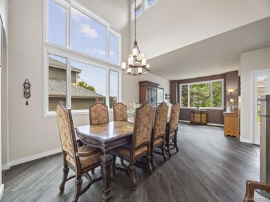
Welcome to this meticulously cared for home at the foot of the Rocky Mountains, located on a quiet cul-de-sac with easy access to Downtown and the Tech Center! Step inside and experience the high ceilings with large windows full of natural light. An oversized family and dining room area is the perfect setting for holiday meals, connected to the large kitchen with upscale Bosch appliances and beautiful countertops. A breakfast nook and large living room are divided by a two sided fireplace for those cool Colorado mornings. The first floor also has a half bath, smart thermostat, and mud room access to the garage. Upstairs are four large bedrooms, with views of the private yard and the foothills that make this feel more like a retreat than a family home. The primary bedroom has a full en-suite with dual vanities, a separate tub and shower, as well as a walk in closet. The finished basement is the perfect hang out spot with a full wet bar including a bar fridge and microwave. Also located in the basement is a fifth bedroom connecting to another full bathroom. The basement living area has enough space for all your friends during the big game, kids sleep overs, or a poker night! Before you leave do not miss the best part - The back yard is finished with maintenance free landscaping, a two tiered deck, and the largest pergola allowed by code! Peace of mind comes with new windows in 2017, a new roof in 2018, new HVAC in 2022, and new flooring in 2025! A low HOA and low taxes make this one a no brainer, schedule your showing today!
Last Agent to Sell the Property
Blue Yeti Homes Brokerage Email: jonpaulmatzke@gmail.com,970-412-1956 License #100079526 Listed on: 06/12/2025
| Date | Buyer | Sale Price | Title Company |
|---|---|---|---|
| Plachy Robert | $880,000 | Chicago Title | |
| Lachance Scott J | $385,000 | None Available | |
| Daurio Christine M | $236,596 | First American Heritage Titl |
| Date | Status | Borrower | Loan Amount |
|---|---|---|---|
| Open | Plachy Robert | $575,000 | |
| Previous Owner | Lachance Scott J | $308,000 |
| Date | Event | Price | List to Sale | Price per Sq Ft |
|---|---|---|---|---|
| 07/14/2025 07/14/25 | Sold | $880,000 | 0.0% | $246 / Sq Ft |
| 06/12/2025 06/12/25 | For Sale | $880,000 | -- | $246 / Sq Ft |
| Year | Tax Paid | Tax Assessment Tax Assessment Total Assessment is a certain percentage of the fair market value that is determined by local assessors to be the total taxable value of land and additions on the property. | Land | Improvement |
|---|---|---|---|---|
| 2024 | $4,263 | $43,531 | $12,311 | $31,220 |
| 2023 | $4,263 | $43,531 | $12,311 | $31,220 |
| 2022 | $4,121 | $41,313 | $11,938 | $29,375 |
| 2021 | $4,174 | $42,501 | $12,281 | $30,220 |
| 2020 | $3,684 | $37,596 | $9,835 | $27,761 |
| 2019 | $3,638 | $37,596 | $9,835 | $27,761 |
| 2018 | $3,447 | $34,402 | $8,954 | $25,448 |
| 2017 | $3,146 | $34,402 | $8,954 | $25,448 |
| 2016 | $3,141 | $33,141 | $7,860 | $25,281 |
| 2015 | $2,731 | $33,141 | $7,860 | $25,281 |
| 2014 | $2,731 | $27,021 | $6,190 | $20,831 |
Seller's Agent in 2025
Jon Paul Matzke
Blue Yeti Homes
(970) 412-1956
1 in this area
66 Total Sales
Buyer's Agent in 2025
Keith Rosenhagen
Rosenhagen Real Estate Professionals
(303) 520-5976
1 in this area
86 Total Sales
Source: REcolorado®
MLS Number: 8597716
APN: 59-213-10-012
Disclaimer: Certain information contained herein is derived from information provided by parties other than Homes.com. All information provided is deemed reliable, but is not guaranteed to be accurate and should be independently verified.
![]() Based on information submitted to the MLS GRID. All data is obtained from various sources and may not have been verified by broker or MLS GRID. Supplied Open House Information is subject to change without notice. All information should be independently reviewed and verified for accuracy. Properties may or may not be listed by the office/agent presenting the information. Some IDX listings have been excluded from this website. The content relating to real estate for sale in this Web site comes in part from the Internet Data eXchange (“IDX”) program of METROLIST, INC., DBA RECOLORADO®. Real estate listings held by brokers other than Ten-X are marked with the IDX Logo. This information is being provided for the consumers’ personal, non-commercial use and may not be used for any other purpose. All information is subject to change and should be independently verified.
Based on information submitted to the MLS GRID. All data is obtained from various sources and may not have been verified by broker or MLS GRID. Supplied Open House Information is subject to change without notice. All information should be independently reviewed and verified for accuracy. Properties may or may not be listed by the office/agent presenting the information. Some IDX listings have been excluded from this website. The content relating to real estate for sale in this Web site comes in part from the Internet Data eXchange (“IDX”) program of METROLIST, INC., DBA RECOLORADO®. Real estate listings held by brokers other than Ten-X are marked with the IDX Logo. This information is being provided for the consumers’ personal, non-commercial use and may not be used for any other purpose. All information is subject to change and should be independently verified.
This publication is designed to provide information with regard to the subject matter covered. It is displayed with the understanding that the publisher and authors are not engaged in rendering real estate, legal, accounting, tax, or other professional services and that the publisher and authors are not offering such advice in this publication. If real estate, legal, or other expert assistance is required, the services of a competent, professional person should be sought.
The information contained in this publication is subject to change without notice. METROLIST, INC., DBA RECOLORADO MAKES NO WARRANTY OF ANY KIND WITH REGARD TO THIS MATERIAL, INCLUDING, BUT NOT LIMITED TO, THE IMPLIED WARRANTIES OF MERCHANTABILITY AND FITNESS FOR A PARTICULAR PURPOSE. METROLIST, INC., DBA RECOLORADO SHALL NOT BE LIABLE FOR ERRORS CONTAINED HEREIN OR FOR ANY DAMAGES IN CONNECTION WITH THE FURNISHING, PERFORMANCE, OR USE OF THIS MATERIAL.
PUBLISHER’S NOTICE: All real estate advertised herein is subject to the Federal Fair Housing Act and the Colorado Fair Housing Act, which Acts make it illegal to make or publish any advertisement that indicates any preference, limitation, or discrimination based on race, color, religion, sex, handicap, familial status, or national origin.
METROLIST, INC., DBA RECOLORADO will not knowingly accept any advertising for real estate that is in violation of the law. All persons are hereby informed that all dwellings advertised are available on an equal opportunity basis.
© 2026 METROLIST, INC., DBA RECOLORADO® – All Rights Reserved. 6455 S. Yosemite St., Suite 500 Greenwood Village, CO 80111 USA
ALL RIGHTS RESERVED WORLDWIDE. No part of this publication may be reproduced, adapted, translated, stored in a retrieval system or transmitted in any form or by any means, electronic, mechanical, photocopying, recording, or otherwise, without the prior written permission of the publisher. The information contained herein including but not limited to all text, photographs, digital images, virtual tours, may be seeded and monitored for protection and tracking.
Based on information submitted to the MLS GRID
Ask me questions while you tour the home.